

Forecast for the Salt Lake Area Mountains
Monday morning, March 11, 2013
The avalanche danger is mostly Low but watch for areas of Moderate Danger in: 1) steep slopes with both old and new deposits of wind drifted snow, which will look smooth and rounded and 2) steep slopes that are getting wet from sun or warmer temperatures.
 Weather and Snow
Snow surface conditions include widespread sun crusts on southerly facing slopes and quite a bit of wind damage in the upper elevation, wind exposed terrain. Mid elevation, northerly slopes still have about 6 inches of dense, dry powder.
Temperatures are in the mid 20's, which is about 10 degrees warmer this morning than yesterday morning and the wind from the northwest has come up and is blowing 30, gusting to 50 on the highest peaks and 15, gusting to 30 on most ridge tops. We have some mid elevation moisture and clouds that should increase throughout the day, which will likely obscure the mountain tops and give us some rime and light snow late this afternoon and tonight.
 Recent Avalanches
Yesterday, a lot of people got cheap avalanche lessons as perhaps a couple dozen people triggered, small, shallow, soft wind slabs and wet sluffs--most were 6 inches deep and 20' wide. The largest was an intentionally-triggered wind slab on the south facing slope in Dry Fork in the backcountry near Alta, which was about 1' deep and 150' wide (photo) . There are many others posts on our Observations page. No one was caught, as far as we know.
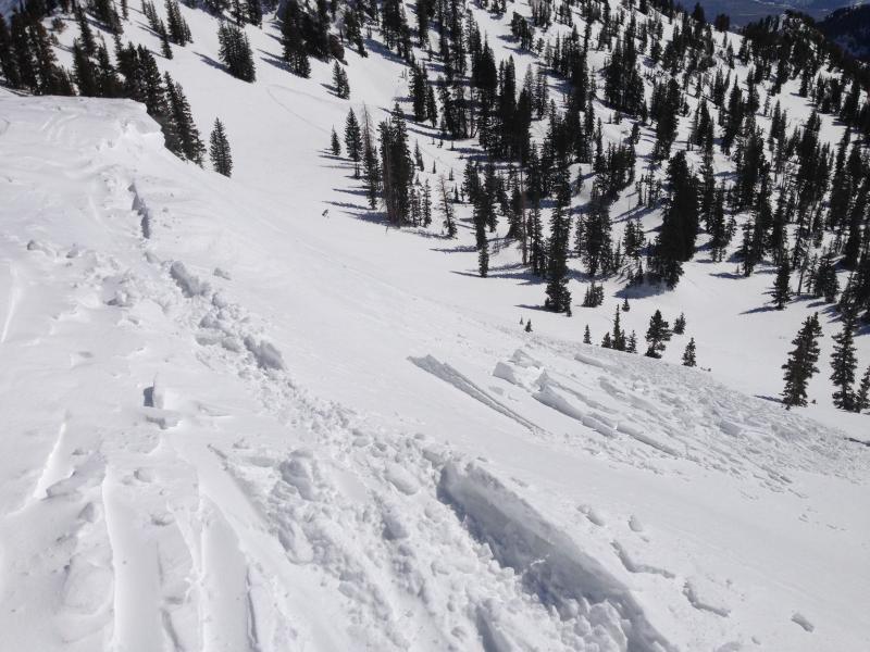
Intentionally-triggered wind slab in Dry fork in the backcountry near Alta on a south facing slope
Persistent Weak Layer
Description
The strong north wind on Friday and Saturday created fairly widespread areas of wind damage in upper elevation wind exposed terrain. Yesterday they were more stubborn but still sensitive enough for people to trigger in many spots. They were quite "manageable" meaning that you could easily recognize and avoid them and they were small. Most were 6 inches deep and not too wide. They were quite localized because many backcountry slopes got completely tracked up without incident.
Today, in theory, most of the old wind slabs should be settled out and they should be much more tame. But this morning, the northwest winds are coming back up again, so you should see some fresh ones building again, mostly along the upper elevation ridges. You will find them mostly on the south through east facing slopes.
As always, be suspicious of recent wind deposits on steep slopes, which will look smooth and rounded.
Wet Snow
Description
Yesterday's strong sun created lots of shallow, wet sluffs on steep slopes as they heated up. Today, we're expecting mid level clouds with continued wind from the northwest. So in theory, they should keep most of the shallow wet sluffs at bay but this time of year you never know. If the clouds are not very thick, we could see more wet activity. These should be mostly shallow and small, but they will be more dangerous in high-consequence terrain such as above terrain traps, trees or cliffs. There is not much snow left on south facing slopes below 8,000' but there is lower elevation snow on east and west facing slopes, which could also get wet.
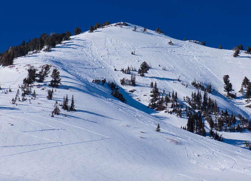
Many people were able to trigger shallow, small slides yesterday, both wind slab and wet sluffs and slabs like this photo from the south facing slope of Flagstaff, a backcountry area near Alta.
Additional Information
It should be a bit of a grey day with increasing mid level clouds that should obscure the mountain tops. By tonight, the clouds could add a layer of rime to the upper elevations with the possibility of a few snowflakes. Ridge top winds have already picked up and are blowing from the northwest 30, gusting to 50 on the highest peaks and 20, gusting to 30 on most ridges. As the ridge builds over us, we will continue to slowly warm. Today will be 10 degrees warmer than yesterday with ridge top temperatures in the mid 20's and near freezing at 8,000'.
Tuesday, skies should be clearing and temperatures will warm to 50 degrees in the mountains by Wednesday and Thursday. We don't see any chance of snow until about a week from today.
General Announcements
Go to http://www.backcountry.com/utah-avalanche-center to get tickets from our partners at Beaver Mountain, Canyons, Sundance, and Wolf Mountain. All proceeds benefit the Utah Avalanche Center.
If you trigger an avalanche in the backcountry - especially if you are adjacent to a ski area – please call the following teams to alert them to the slide and whether anyone is missing or not. Rescue teams can be exposed to significant hazard when responding to avalanches, and do not want to do so when unneeded. Thanks.
Salt Lake and Park City – Alta Central (801-742-2033), Canyons Resort Dispatch (435-615-3322)
Ogden – Snowbasin Patrol Dispatch (801-620-1017)
Powder Mountain Ski Patrol Dispatch (801-745-3772 ex 123)
Provo – Sundance Patrol Dispatch (801-223-4150)
Dawn Patrol Forecast Hotline, updated by 05:30: 888-999-4019 option 8.
Twitter Updates for your mobile phone - DETAILS
Daily observations are frequently posted by 10 pm each evening.
Subscribe to the daily avalanche advisory e-mail click HERE.
UDOT canyon closures UDOT at (801) 975-4838
Wasatch Powderbird Guides does daily updates about where they'll be operating on this blog http://powderbird.blogspot.com/ .
Remember your information can save lives. If you see anything we should know about, please participate in the creation of our own community avalanche advisory by submitting snow and avalanche conditions. You can also call us at 801-524-5304 or 800-662-4140, email by clicking HERE, or include #utavy in your tweet.
Donate to your favorite non-profit –The Friends of the Utah Avalanche Center. The UAC depends on contributions from users like you to support our work.
For a print version of this advisory click HERE.
This advisory is produced by the U.S. Forest Service, which is solely responsible for its content. It describes only general avalanche conditions and local variations always exist. Specific terrain and route finding decisions should always be based on skills learned in a field-based avalanche class.