

Forecast for the Salt Lake Area Mountains

Saturday morning, March 9, 2013
Most of the terrain has a pockety MODERATE avalanche danger today. Watch for fresh drifts along the ridges and other terrain features and pay attention if the sun comes out and heats the new snow.
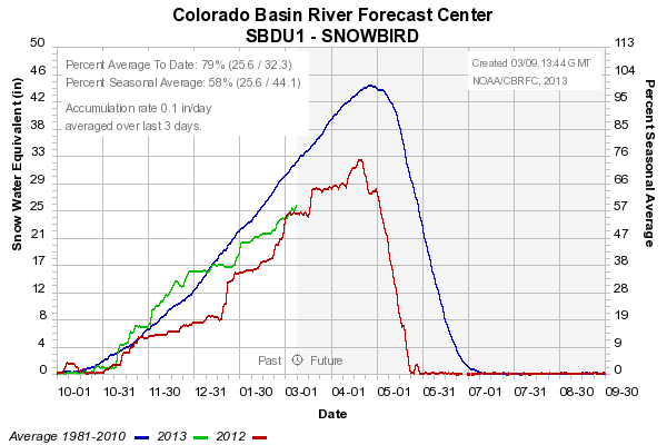
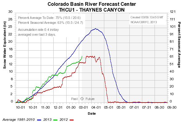
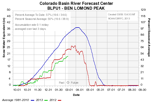
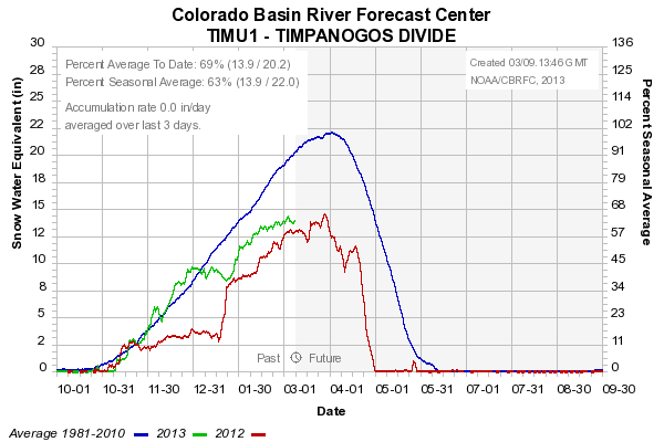
 Weather and Snow
24 hour storm totals as of 6am this morning are 3 to 6 inches in the upper Cottonwoods, 7 to 9 inches along the Park City Ridgeline, 2 to 3 inches in the Provo region and the Ogden area mountains didn't pick up much to speak of. Temperatures are in the low to mid 20s. Winds started out southerly and switched more east overnight and are now working around to the north currently still in the light to moderate category.
 Recent Avalanches
We are sliding more and more toward a spring like pattern where we are dealing mainly with new snow instabilities. With each storm we need to pay attention to any instabilities that may be within the new snow and pay attention to what the winds do to the new snow. As the storm clears, our attention quickly turns to warming and anticipating the new snow to become unstable as it adjusts to it's first couple of warm ups.
With the below average snowpack depths there's plenty of areas that contain preexisiting weak layers of faceted snow. However, with no significant new snow load on the horizon, these layers don't pose much threat currently.

Persistent Weak Layer
Description
During my field day on Friday I did not note any instabilities within the small amount of new snow. My thoughts are that the increase in northerly wind speeds may be enough to drift some snow into small drifts that may crack out along the ridges on the southerly facing slopes. These shouldn't pose much threat unless you blatantly disregard them and get onto exposed terrain where they are present.
Wet Snow
Description
Watch for the new snow to become unstable if the sun peeks out during the day. This avalanche problem shouldn't pose much threat either but be aware that the sun can change the new snow conditions rapidly producing wet loose avalanches. "Roller Balls" or "pinwheels" are indicators that the new snow is getting damp. Stay out of the bottom of steep runout zones and terrain traps where a natural loose snow slide could funnel down on top of you.
New Snow
Description
Once gain, the new snow should always be evaluated for instabilities within it. I don't think that it will be sensitive but don't dismiss it until you do your own evaluation.
Additional Information
Lingering snow showers should come to an end as the storm continues to slide of to our southeast. Temperatures should get into the mid to upper 20s. Winds will be primarily from the north and will increase in speed a bit during the day. I don't think they'll get really strong but enough so to make note. Skies could break a bit as the sun attempts to poke through later today.
General Announcements
Go to http://www.backcountry.com/utah-avalanche-center to get tickets from our partners at Beaver Mountain, Canyons, Sundance, and Wolf Mountain. All proceeds benefit the Utah Avalanche Center.
If you trigger an avalanche in the backcountry - especially if you are adjacent to a ski area – please call the following teams to alert them to the slide and whether anyone is missing or not. Rescue teams can be exposed to significant hazard when responding to avalanches, and do not want to do so when unneeded. Thanks.
Salt Lake and Park City – Alta Central (801-742-2033), Canyons Resort Dispatch (435-615-3322)
Ogden – Snowbasin Patrol Dispatch (801-620-1017)
Powder Mountain Ski Patrol Dispatch (801-745-3772 ex 123)
Provo – Sundance Patrol Dispatch (801-223-4150)
Dawn Patrol Forecast Hotline, updated by 05:30: 888-999-4019 option 8.
Twitter Updates for your mobile phone - DETAILS
Daily observations are frequently posted by 10 pm each evening.
Subscribe to the daily avalanche advisory e-mail click HERE.
UDOT canyon closures UDOT at (801) 975-4838
Wasatch Powderbird Guides does daily updates about where they'll be operating on this blog http://powderbird.blogspot.com/ .
Remember your information can save lives. If you see anything we should know about, please participate in the creation of our own community avalanche advisory by submitting snow and avalanche conditions. You can also call us at 801-524-5304 or 800-662-4140, email by clicking HERE, or include #utavy in your tweet.
Donate to your favorite non-profit –The Friends of the Utah Avalanche Center. The UAC depends on contributions from users like you to support our work.
For a print version of this advisory click HERE.
This advisory is produced by the U.S. Forest Service, which is solely responsible for its content. It describes only general avalanche conditions and local variations always exist. Specific terrain and route finding decisions should always be based on skills learned in a field-based avalanche class.