


Forecast for the Salt Lake Area Mountains
Tuesday morning, March 5, 2013
Avoid: 1) any steep slope with recent wind deposits, and 2) Any steep slope with new snow that is getting wet from rapidly warming temperatures or sun.
You can always find safer terrain on slopes less steep than about 30 degrees that are not underneath or locally connected to steeper terrain.
 Special Announcements
I posted a blog on Avalanche Airbag Effectiveness - Something Closer to the Truth
 Weather and Snow
Yesterday, the winds really cranked up from the west and northwest and created widespread areas of wind drifting in upper elevation, wind exposed terrain. The 6 inches of new snow on Sunday helped to smooth over the plethora of tracks and sun crusts. It was cold overnight with temps from just below zero to the teens. Expect rapid warming today with sun.
 Recent Avalanches
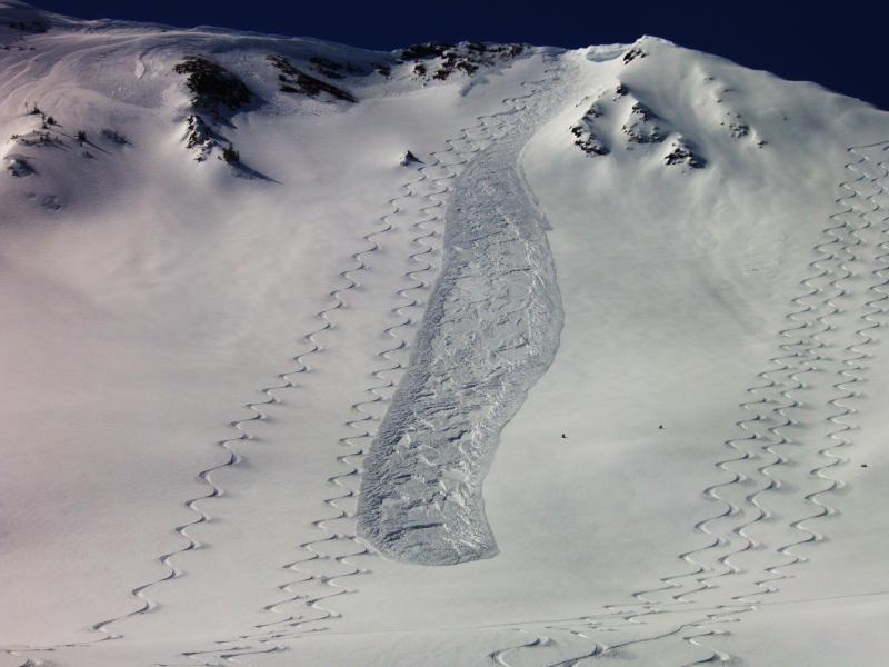
Yesterday several people were able to trigger wind fresh wind slabs. Most were in the "manageable" category, less than a foot deep, easily recognizable and one person found themselves on the wrong side of the fracture line but quickly self-arrested. You can find several good reports in our avalanche list including from Cardiac (photo below) and Days Fork.

Persistent Weak Layer
Description
The bad news is that the winds really cranked up yesterday and did lots of damage in the upper elevation alpine terrain. The good news is there was only about 6 inches of new snow to blow around so the slabs were mostly shallow and what we would call "manageable" meaning that they are easy to recognize and avoid by their smooth, rounded shape and "slabby" feel and they were mostly soft enough to break at your feet instead of above you.
I would expect that these wind slabs will have settled out by today, making them much harder to trigger. The main problem areas will likely be wind slabs that rapidly heat up in the strong spring sun. Our forecaster Evelyn Lees created the cool Venn diagram below. In other words, the lingering wind slabs will be most dangerous on the southeast, south and southwest facing slopes as they rapidly warm in the sun today.

Wet Snow
Description
Like people, snow does not like rapid change. Today the temperatures will rapidly rise both from warmer air moving in from the south and from the strong spring sun. Temperatures should rapidly rise from near zero and the single digits this morning to the mid 40's. Expect to see widespread areas of damp to wet avalanches on all the steep slopes. Most of the avalanches will be relatively shallow, around 6 inches or less, but some of the wind drifts may be a foot-or-so deep. As always, stay off of, and out from underneath, steep slopes when they get wet. You should be able to find wet avalanche potential at most aspects and elevations today with the exception of the upper elevation shady slopes and the low elevation slopes that did not get much new snow on Sunday. Stronger winds from the southwest this afternoon may help keep wet activity at bay.
Additional Information
Did I mention rapid warming? Temperatures will zoom from near zero to the single digits up into the mid 40's today, both from warmer air blowing into our area and from the strong March sun. Skies will be clear. The ridge top winds will increase today to 20, gusting to 30 mph from the southwest in advance of our next weather system.
Wednesday through Saturday we will have one of those problematic closed lows that will dive south of us into northern Arizona. We normally don't get much snow out of these frustrating storms but we should be able to squeeze 2-4 inches out of it over 4 days. The first wave on Wednesday should favor the Logan area.
General Announcements
Go to http://www.backcountry.com/utah-avalanche-center to get tickets from our partners at Beaver Mountain, Canyons, Sundance, and Wolf Mountain. All proceeds benefit the Utah Avalanche Center.
If you trigger an avalanche in the backcountry - especially if you are adjacent to a ski area – please call the following teams to alert them to the slide and whether anyone is missing or not. Rescue teams can be exposed to significant hazard when responding to avalanches, and do not want to do so when unneeded. Thanks.
Salt Lake and Park City – Alta Central (801-742-2033), Canyons Resort Dispatch (435-615-3322)
Ogden – Snowbasin Patrol Dispatch (801-620-1017)
Powder Mountain Ski Patrol Dispatch (801-745-3772 ex 123)
Provo – Sundance Patrol Dispatch (801-223-4150)
Dawn Patrol Forecast Hotline, updated by 05:30: 888-999-4019 option 8.
Twitter Updates for your mobile phone - DETAILS
Daily observations are frequently posted by 10 pm each evening.
Subscribe to the daily avalanche advisory e-mail click HERE.
UDOT canyon closures UDOT at (801) 975-4838
Wasatch Powderbird Guides does daily updates about where they'll be operating on this blog http://powderbird.blogspot.com/ .
Remember your information can save lives. If you see anything we should know about, please participate in the creation of our own community avalanche advisory by submitting snow and avalanche conditions. You can also call us at 801-524-5304 or 800-662-4140, email by clicking HERE, or include #utavy in your tweet.
Donate to your favorite non-profit –The Friends of the Utah Avalanche Center. The UAC depends on contributions from users like you to support our work.
For a print version of this advisory click HERE.
This advisory is produced by the U.S. Forest Service, which is solely responsible for its content. It describes only general avalanche conditions and local variations always exist. Specific terrain and route finding decisions should always be based on skills learned in a field-based avalanche class.