

Forecast for the Ogden Area Mountains

Monday morning, March 4, 2013
A MODERATE danger exists in the backcountry and remains elevation dependent. Human triggered avalanches within the recent storm or wind-driven snow are possible at the mid and upper elevations, though stability should be on the rise as the day wears on. The lower elevations still host a MODERATE danger for wet loose slides that may continue to gouge into wet loose grains near the ground. Any direct sun will be a game changer and wet loose sluffs will again be likely on the steep sun-drenched slopes.
 Weather and Snow
Skies are overcast with the last few snowflakes putting the finishing touches on a nice little storm for the range. Yesterday's rain/snow lines roughly started at 8000' and slowly lowered to 7000'...though by the time it was all said and done, most areas picked up 5-6" of 10% yesterday with an additional 1-3" of 12% snow or graupel overnight. Good to have 6-10" of snow with a little meat to it to smooth over the myriad sun and wind crusts from the weekend.
Temps have fallen with the cold front and are now 10-15 degrees below Saturday night's lows...they're in the mid teens up high, the low 20s down low. Despite the cool-off, I suspect the rain-saturated snowpack below 8000' failed to adequately 'lock-up', and one may find themselves punching through to the ground in thinner areas, particularly on the north end of the compass.
The west to northwest winds are 10-15mph except for the highest ridgelines, where anemometers spin at 30-35mph with gusts to 50.
If you find yourself with time to kill or are having trouble getting to sleep at night, look into the latest Blog post - "Danger in the Danger Ratings" (Comments are encouraged - after all, the danger ratings are for you).
 Recent Avalanches
Activity was elevation dependent yesterday:
- In the lower elevations (<8000'), wet activity ruled the day and we most notably heard of wet loose sluffs on the steep northerly terrain, with some gouging into older saturated snow.
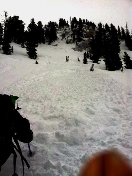
- Above 9500', backcountry observers and avalanche control teams reported shallow wind slab less than 1' deep and prominently formed adjacent to ridgelines and cliffbands. One skier had a 8" deep and 20' wide soft slab break above him on the north side of the Cottonwood ridgeline and was caught and carried with no reports of injury or lost gear. This on a steep northerly slope at 9800'. (photo below).

Persistent Weak Layer
Description
Shallow wind slabs dot the high lee exposed terrain again today and will more more pronounced on steep north through east through south facing slopes. They'll be smooth and rounded and representative test slopes may crack out up to 8-14" deep.
New Snow
Description
Storm snow avalanches will be on the mend, though initial travel through steeper terrain may hold areas of sensitive upside down snow or density breaks within the 6-10" storm totals. This, as with the wind slabs mentioned above, will be easily managed with safe ski and slope cuts and cornice drops and good terrain management.
Wet Snow
Description
The lower elevations likely remain saturated and punchy. If you find yourself punching your ski pole or probe - or even skis/sled/snowshoes - down through the wet uncohesive glop, move to lower angle terrain. Much of the wet activity came in lock-step with Saturday's sun and Sunday's rain; still, the lower elevations - particularly on the northerly (west-north-east) facing slopes are still a concern.
Today and tomorrow's sun will usher in a new round of wet loose sluffs, both natural and prone to human triggering, on the steep sunny aspects.
Additional Information
Skies should start to clear, the winds will start to wind down, and it'll be a pleasant day in the hills. Temps will rise to the low teens at 10,000', the mid-20s at 8000'. The northwesterly winds should lose steam and blow 10-15mph from the west. Skies clear and rapid warming takes hold for tomorrow, with 10,000' temps warming toward the low 30s...ahead of a large scale weather system that starts to affect the intermountain west by Wednesday. Strong southerly winds late Tuesday night precede the storm system, slated to stay overhead through the weekend. The bulk of the precipitation looks to affect southern and central Utah, but the north will see it's share. Stay tuned.
General Announcements
Go to http://www.backcountry.com/utah-avalanche-center to get tickets from our partners at Beaver Mountain, Canyons, Sundance, and Wolf Mountain. All proceeds benefit the Utah Avalanche Center.
If you trigger an avalanche in the backcountry - especially if you are adjacent to a ski area – please call the following teams to alert them to the slide and whether anyone is missing or not. Rescue teams can be exposed to significant hazard when responding to avalanches, and do not want to do so when unneeded. Thanks.
Salt Lake and Park City – Alta Central (801-742-2033), Canyons Resort Dispatch (435-615-3322)
Ogden – Snowbasin Patrol Dispatch (801-620-1017)
Powder Mountain Ski Patrol Dispatch (801-745-3772 ex 123)
Provo – Sundance Patrol Dispatch (801-223-4150)
Dawn Patrol Forecast Hotline, updated by 05:30: 888-999-4019 option 8.
Twitter Updates for your mobile phone - DETAILS
Daily observations are frequently posted by 10 pm each evening.
Subscribe to the daily avalanche advisory e-mail click HERE.
UDOT canyon closures UDOT at (801) 975-4838
Wasatch Powderbird Guides does daily updates about where they'll be operating on this blog http://powderbird.blogspot.com/ .
Remember your information can save lives. If you see anything we should know about, please participate in the creation of our own community avalanche advisory by submitting snow and avalanche conditions. You can also call us at 801-524-5304 or 800-662-4140, or email by clicking HERE
Donate to your favorite non-profit –The Friends of the Utah Avalanche Center. The UAC depends on contributions from users like you to support our work.
For a print version of this advisory click HERE.
This advisory is produced by the U.S. Forest Service, which is solely responsible for its content. It describes only general avalanche conditions and local variations always exist. Specific terrain and route finding decisions should always be based on skills learned in a field-based avalanche class.