

Forecast for the Ogden Area Mountains

Saturday morning, March 2, 2013
The danger will rise to MODERATE today in lockstep with direct sun and skyrocketing temperatures. Both natural and human triggered avalanches gouging up to a foot deep are probable on all steep sunlight terrain. Collapsing is a significant red flag today. Along the ridgelines, recent windslabs may be more sensitive to human triggering...and remember to give cornices a wide berth.
 Special Announcements
It was a rough day in the avalanche world yesterday.
By now, most of you likely know of the fatality down in Sevier County on the Manti-Skyline Plateau. A 30 year old male snowmobiler was killed in an avalanche in the afternoon. Brett Kobernik is heading down to conduct the investigation and will have at least preliminary information on this page by tonight.
Elsewhere - in the Tetons, a 40 year old local was killed while ascending what they call the Apocalypse Couloir in Grand Teton National Park. Also, a very good friend in Colorado went for a long ride, deployed his airbag, and ended up on top of the debris...but is likely out for the season with knee injuries.
 Weather and Snow
Spring.
Skies are partly cloudy, winds are light, and overnight lows are in the mid to upper 20s. Snow surface conditions are littered with myriad wind, sun, and now rime crusts (most pronounced on northerly and westerly slopes). Have at it. I'll be out there too.
It'll feel like our first heat wave of the season as temps soar into the mid to upper 40s in the mountains...a good thaw from one of the colder winters we've had for awhile.
 Recent Avalanches
Little activity to report from yesterday -
- In the south fork of Provo Canyon, a skier along a ridgeline remotely triggered a 1' deep and 100' wide wind pocket on a steep southeast facing slope at 10,100'.
- Some fairly minor wet loose avalanches released naturally from daytime heating; "greenhousing" also provoked some wet pinwheels on northerly terrain up to 7000'.

Wet Snow
Description
Your primary avalanche concern - easily avoided through timing and terrain selection - will be the significant thaw on the steep east through south through westerly facing slopes today. Both shallow wet natural and human triggered sluffs are likely with the direct sun and daytime warming. It may be possible for any of these wet loose sluffs to gouge down into the more structured snowpack on the southerly aspects....creating a larger debris pile.
If you find yourself augering into the wet unconsolidated grains, you've overstayed your welcome. Choose lower angled terrain...try to remain on subridges...and be mindful of avoiding being above terrain traps such as steep walled gullies or creekbeds. Early starts and careful choices for exits are key.
New Snow
Description
We're getting into a little black magic with this - the collapse failure of a structured snowpack on the southerly facing slopes. Facet/crust layers of interest lie about a foot or so beneath the snow surface and have healed little in the past few days. They've been the culprit with a few human triggered slides earlier in the week...and today's rapid warming may affect the mechanical properties of the snowpack here and work as a catalyst for this type of persistent slab again. Bottom line here - collapsing of the snowpack will be key to choosing different or low angle terrain.
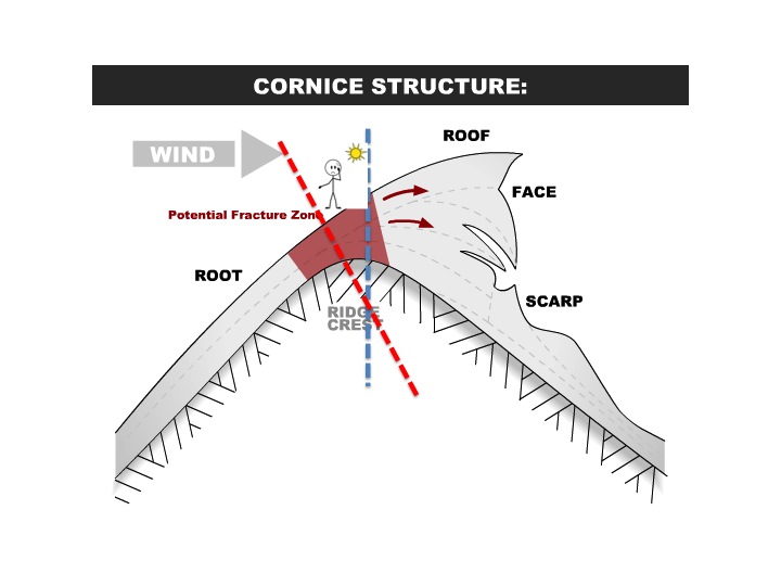
Cornice
Description
We've all seen how rapid warming affects deforms the snowpack - settlement cones, surface snow "creeping" up the uphill side of trees and pulling away from the downhill...slabs and cornices tend to lose strength - "toughness" with the onset of rapid warming and may be more prone to triggering. Some of these yawning whale cornices may fail today and break back much farther than you think. Note the cartoon below...many people think the cornice will break off vertically at the apex of the ridgeline...Not so with older, harder cornices...more often, it breaks back at an angle - the red line depicts where the cornice may pull out behind our hero...
Additional Information
Sunny skies will prevail today, accompanied by light backing winds and temps rising to the upper 40s at 8000' and the mid to upper 30s at 10,000'. We'll see increasing clouds tonight ahead of a clipper system tomorrow that should bring 3-6" to the mountains while dropping temps back down to the low teens by Monday. Ridging redevelops by Monday/Tuesday ahead of a series of convoluted systems for mid to late week.
General Announcements
Go to http://www.backcountry.com/utah-avalanche-center to get tickets from our partners at Beaver Mountain, Canyons, Sundance, and Wolf Mountain. All proceeds benefit the Utah Avalanche Center.
If you trigger an avalanche in the backcountry - especially if you are adjacent to a ski area – please call the following teams to alert them to the slide and whether anyone is missing or not. Rescue teams can be exposed to significant hazard when responding to avalanches, and do not want to do so when unneeded. Thanks.
Salt Lake and Park City – Alta Central (801-742-2033), Canyons Resort Dispatch (435-615-3322)
Ogden – Snowbasin Patrol Dispatch (801-620-1017)
Powder Mountain Ski Patrol Dispatch (801-745-3772 ex 123)
Provo – Sundance Patrol Dispatch (801-223-4150)
Dawn Patrol Forecast Hotline, updated by 05:30: 888-999-4019 option 8.
Twitter Updates for your mobile phone - DETAILS
Daily observations are frequently posted by 10 pm each evening.
Subscribe to the daily avalanche advisory e-mail click HERE.
UDOT canyon closures UDOT at (801) 975-4838
Wasatch Powderbird Guides does daily updates about where they'll be operating on this blog http://powderbird.blogspot.com/ .
Remember your information can save lives. If you see anything we should know about, please participate in the creation of our own community avalanche advisory bysubmitting snow and avalanche conditions. You can also call us at 801-524-5304 or 800-662-4140, or email by clicking HERE
Donate to your favorite non-profit –The Friends of the Utah Avalanche Center. The UAC depends on contributions from users like you to support our work.
For a print version of this advisory click HERE.
This advisory is produced by the U.S. Forest Service, which is solely responsible for its content. It describes only general avalanche conditions and local variations always exist. Specific terrain and route finding decisions should always be based on skills learned in a field-based avalanche class.