

Forecast for the Ogden Area Mountains

Tuesday morning, February 26, 2013
The avalanche danger is MODERATE for triggering a wind drift on steep mid and upper elevation slopes, especially those facing northeast through southeast. This danger increases with elevation and with the amount of new snow. Practice safe travel habits of only exposing one person at a time and use and practice with your avalanche safety gear.
 Weather and Snow
A weak shortwave in a moist northwesterly flow is producing light snow fall this morning, with accumulation in the 1 to 4” range as of 6 am. Temperatures remain wintery, in the single digits to low teens. The northwesterly winds are generally averaging less than 15 mph, with the exception of the 11,000’ peaks, where 25 to 30 mph average speeds are occurring, with gusts in the 40s. The remaining dense powder is limited to the shady, northerly facing slopes.
 Recent Avalanches
Provo area mountains: a decent size natural wet loose sluff on an east facing slope in Cascade Cirque. Also a small skier triggered hard slab on a southwest facing slope at 11,000’ in American Fork.
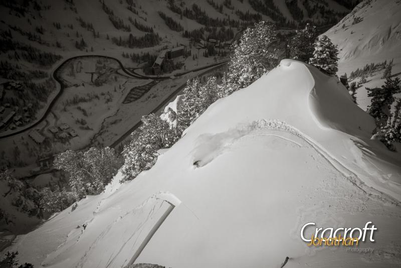
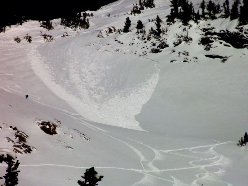
Salt Lake/Park City mountains: two skier triggered slides that carried the skiers for short distances – one was on a southwest facing slope in Toledo Bowl, 10" x 150'. The other was in Hellgate Back Bowl area, on a southeast facing slope. Explosive work in the Cottonwood resorts released new snow slides up to 2 feet deep on upper elevation northerly facing slopes.
Ogden mountains: a few isolated wind slabs with explosives.
First photo - Hellgate slide
Second photo - Toledo Bowl

Persistent Weak Layer
Description
The overnight southwest to northwesterly winds will have created another batch of sensitive wind drifts, on top of the more settled wind drifts from over the weekend.
Cutler Ridge, weekend wind affect.
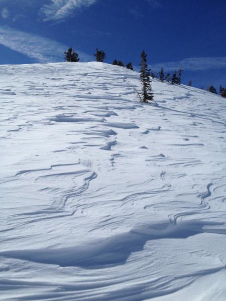
These newest wind slabs and cornices will be sensitive to people on steep slopes, running on the hard sun crusts or some slightly faceted surface snow on northerly facing slopes. As always, drifts can be cross loaded on a variety of aspects and around gully walls and sub ridges.
The upper elevation 11,000' wind speeds will make it a different world for anyone traveling to the highest terrain, especially in the Salt Lake and Provo area mountains. Notch up the avalanche danger…to CONSIDERABLE, with natural avalanches possible, if you are traveling in or directly below the upper elevation terrain, especially areas that receive 6 or more inches of new snow.
Wind Drifted Snow
Description
Snowpack variation and the possibility of afternoon sun means you need to stay on your toes and constantly evaluate your terrain choices and their consequences, especially in radical terrain and at the highest elevations. In addition to wind slabs, also think about:
- Sluffing of the newest snow, on all aspects and elevations, from the sun crusted slopes to the shaded slopes, including low elevation northerly facing slopes.
- Heating – a possible late afternoon appearance of the sun may make the snow on steep sunny slopes more sensitive again.
- A few isolated, mostly mid elevation northerly facing slopes, where you could trigger a slab on the mid pack facets.
Additional Information
It’s going to be another cold winter day, with temperatures remaining near 10 degrees along the high ridges and warming only into the mid to upper teens at 8,000’. Skies will remain cloudy for most of the day, with light snow showers adding another few inches of low density snow. The winds will remain from the northwest, with most stations in the 10 to 15 mph range. The significantly stronger winds speed of the 11,000’ high peaks will decrease throughout the day. The sun may start to peek out this afternoon, as high pressure starts to build in for the rest of the week, with much warmer temperatures by the weekend.
General Announcements
Go to http://www.backcountry.com/utah-avalanche-center to get tickets from our partners at Beaver Mountain, Canyons, Sundance, and Wolf Mountain. All proceeds benefit the Utah Avalanche Center.
If you trigger an avalanche in the backcountry - especially if you are adjacent to a ski area – please call the following teams to alert them to the slide and whether anyone is missing or not. Rescue teams can be exposed to significant hazard when responding to avalanches, and do not want to do so when unneeded. Thanks.
Salt Lake and Park City – Alta Central (801-742-2033), Canyons Resort Dispatch (435-615-3322)
Ogden – Snowbasin Patrol Dispatch (801-620-1017)
Powder Mountain Ski Patrol Dispatch (801-745-3772 ex 123)
Provo – Sundance Patrol Dispatch (801-223-4150)
Dawn Patrol Forecast Hotline, updated by 05:30: 888-999-4019 option 8.
Twitter Updates for your mobile phone - DETAILS
Daily observations are frequently posted by 10 pm each evening.
Subscribe to the daily avalanche advisory e-mail click HERE.
UDOT canyon closures UDOT at (801) 975-4838
Wasatch Powderbird Guides does daily updates about where they'll be operating on this blog http://powderbird.blogspot.com/ .
Remember your information can save lives. If you see anything we should know about, please participate in the creation of our own community avalanche advisory bysubmitting snow and avalanche conditions. You can also call us at 801-524-5304 or 800-662-4140, or email by clicking HERE
Donate to your favorite non-profit –The Friends of the Utah Avalanche Center. The UAC depends on contributions from users like you to support our work.
For a print version of this advisory click HERE.
This advisory is produced by the U.S. Forest Service, which is solely responsible for its content. It describes only general avalanche conditions and local variations always exist. Specific terrain and route finding decisions should always be based on skills learned in a field-based avalanche class.