Forecast for the Salt Lake Area Mountains

Monday morning, February 25, 2013
Most terrain has a MODERATE avalanche hazard. Problem areas are terrain with recent wind drifts which exists mostly in the upper elevations. Be watchful of wet activity on sunny aspects.
 Special Announcements
Forecast written and compiled by Greg Gagne, approved by Brett Kobernik
 Weather and Snow
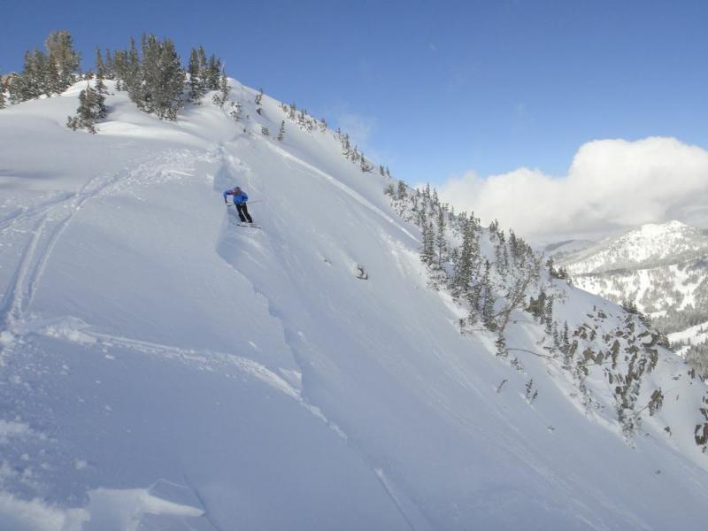
Spectacular riding and weather conditions reported on Sunday in the 8"-16" new from the Saturday storm. Although the winds were strong during and after frontal passage with wind-drifted snow on all aspects, most reported the new snow and fresh wind drifts as stubborn. Since early Sunday morning winds have died down and are now light out of the North and Northwest. Despite the warm late-February sun, temperatures stayed cool during the day on Sunday and are in the single digits this morning.
The warm sun did affect Southerly aspects on Sunday and you will likely find these aspects to be crusted this morning.
 Recent Avalanches
Several slides were reported from Sunday, most involving fresh wind drifts. These include Mount Tuscarora (DETAILS) on a South/Southeast aspect at 10,600', South-facing Mount Superior (DETAILS), and North-facing Dutch Draw (DETAILS) along the Park City ridgeline at 8,600'. These slides all involved fresh wind drifts and were 8"-16" deep. One particularly interesting side was reported from the Brighton backcountry on a steep Northwest aspect at 9,800' which involved failing on a layer of preserved facets (DETAILS).
Control work from UDOT and resorts reported limited results with mostly Class 2 slides.

Persistent Weak Layer
Description
Although we are expecting wind drifts to be even less sensitive today, I would approach any steep, wind-drifted slope with caution.
Although I am not expecting this to be all that widespread a problem, the slide in the Brighton backcountry reminds us that faceted snow may be preserved underneath the recent wind drifts on sheltered northerly aspects at elevations below about 9,500'.
Wet Snow
Description
Although the Southerly winds and afternoon clouds may keep a lid on wet activity, the strong late February sun may easily affect Southerly aspects with wet slides and damp roller balls. Pay attention to slopes what you are on as well as what is above you on terrain that faces South through West.
Additional Information
Another nice day on tap ahead of a nice refresher expected overnight. Sunny skies this morning will give way to mid and high level clouds later this afternoon. Temperatures are expected to be in the mid 20's. Winds shifting to the West/Southwest with gusts to 30 mph ahead of a cold trough overnight. Storm totals of 5"-10" are expected by mid-day Tuesday.
General Announcements
Go to http://www.backcountry.com/utah-avalanche-center to get tickets from our partners at Beaver Mountain, Canyons, Sundance, and Wolf Mountain. All proceeds benefit the Utah Avalanche Center.
If you trigger an avalanche in the backcountry - especially if you are adjacent to a ski area – please call the following teams to alert them to the slide and whether anyone is missing or not. Rescue teams can be exposed to significant hazard when responding to avalanches, and do not want to do so when unneeded. Thanks.
Salt Lake and Park City – Alta Central (801-742-2033), Canyons Resort Dispatch (435-615-3322)
Ogden – Snowbasin Patrol Dispatch (801-620-1017)
Powder Mountain Ski Patrol Dispatch (801-745-3772 ex 123)
Provo – Sundance Patrol Dispatch (801-223-4150)
Dawn Patrol Forecast Hotline, updated by 05:30: 888-999-4019 option 8.
Twitter Updates for your mobile phone - DETAILS
Daily observations are frequently posted by 10 pm each evening.
Subscribe to the daily avalanche advisory e-mail click HERE.
UDOT canyon closures UDOT at (801) 975-4838
Wasatch Powderbird Guides does daily updates about where they'll be operating on this blog http://powderbird.blogspot.com/ .
Remember your information can save lives. If you see anything we should know about, please participate in the creation of our own community avalanche advisory bysubmitting snow and avalanche conditions. You can also call us at 801-524-5304 or 800-662-4140, or email by clicking HERE
Donate to your favorite non-profit –The Friends of the Utah Avalanche Center. The UAC depends on contributions from users like you to support our work.
For a print version of this advisory click HERE.
This advisory is produced by the U.S. Forest Service, which is solely responsible for its content. It describes only general avalanche conditions and local variations always exist. Specific terrain and route finding decisions should always be based on skills learned in a field-based avalanche class.


