

Forecast for the Uintas Area Mountains

Sunday morning, February 24, 2013
At and above treeline the avalanche danger is CONSIDERABLE and human triggered avalanches are likely on steep, wind drifted, leeward slopes, especially those facing the north half of the compass. Once triggered, avalanches have the possibility to break into deeper buried weak layers, producing a dangerously unmanageable avalanche.
Mid elevation terrain offers a MODERATE avalanche danger and human triggered avalanches are possible on steep wind drifted slopes.
If you're looking for LOW avalanche danger, head to mid and low elevation wind sheltered terrain or carve turns on flat meadows with no steep slopes above or adjacent to where you're riding.
Special Avalanche Bulletin
Avalanche conditions remain dangerous, especially on steep, upper elevation, leeward slopes facing the north half of the compass.
 Special Announcements
The beacon checker at Nobletts Trailhead is having issues. I'll get there in the morning to diagnose the problem... thanks for your patience.
Our entire Uinta weather station network is up and running. A link to real-time wind, snow, and temperature data can be found here.
This monumental achievement couldn't have happened without the joint efforts from the National Weather Service, The Heber-Kamas and Evanston Ranger Districts, Park City Powder Cats, and all the great work by Ted, Trent, Cody, and Al. Thanks to everyone... this is awesome!
 Weather and Snow
Skies are mostly cloudy and light snow showers are still falling as the weekend system begins winding down. Unfortunately, yesterday's storm was in a hurry to get to Colorado, racing through the region and just deposing 6"-8" of super light density snow. Currently, temperatures are near zero, while north and northwest winds blow 15-25 mph along the ridges with gusts in the 30's and 40's along the high peaks. We've received over a foot of snow this week and it's deep out there... it'll be over the hood and in your face in mid elevation wind sheltered terrain.
Recent observations can be found here.
Wondering why last winter was so crazy? Click here to watch the 2011-12 Utah Winter Review... an excellent recap of last years conditions.
 Recent Avalanches
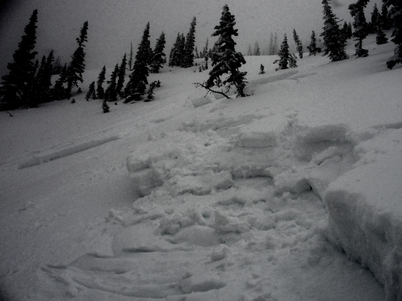
No new avalanche activity to report, Thursday's hard slab on The Duke is worth noting. Triggered low on slope and breaking to the weak January facets, this northwest aspect at 10, 400' is about a foot and half deep, 150' wide, and ran for 300' vertical. Many thanks to Michael J for all the killer info this year and for this great observation.
Click here for recent observations from the region.

Persistent Weak Layer
Description
While storm totals didn't materialize as predicted, yesterday's west and southwest winds helped change the landscape. With no shortage of light density snow, winds formed sensitive drifts along the leeward side of mid and upper elevation ridges and around terrain features like chutes and gullies. Overnight, things have changed a bit and the slabs might not be quite as tender or reactive. The down side to the tenuous balance... as the recent drifts gain strength they can break deeper and wider than you might expect. Avoiding steep slopes with fat rounded pillows of snow is gonna be your best offense today.
New Snow
Description
The recent round of snow and wind slowly loaded the snowpack and laid down an evenly distributed slab. It wasn't a sudden, rapid load when everything comes unglued and we see big slides. It was more subtle and I suspect the January facets, now buried several feet below the snow surface, are adjusting to the storms. While the snow may feel strong and solid under skis, board, or sled the snowpack might not feel our same emotion. Remember... it's these type of snow conditions that allow us to get well out onto the slope before it fails and we trigger a deep, dangerous slide. Making conditions tricky and unpredictable is the possibility of triggering a slide mid slope or on your approach from the bottom. Best way to combat this condition is with terrain management and by gathering information as you travel throughout the day. Tweak some small test slopes and road cuts. See how they're reacting before charging into big, committing terrain..
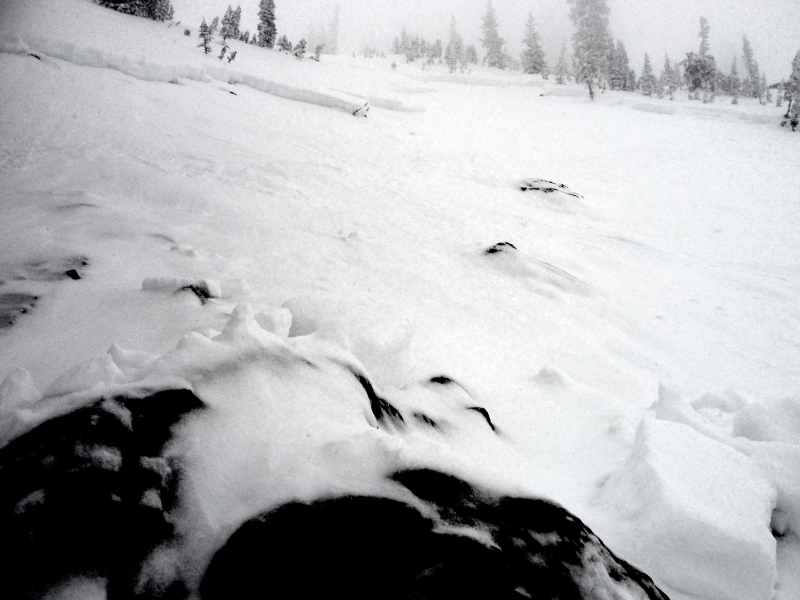
More images from Thursday's slide on The Duke. Our snowpack is relatively thin for mid February and you can clearly see this slide broke to weak snow, especially near and around rocks low on the slope.
Additional Information
We should still see a few snow showers throughout the morning as yesterday's storm pulls away from the region. Northerly winds blowing 20-30 mph along the high ridges will add a bite to the air. High temperatures only reach into the teens before crashing into negative territory overnight. High pressure returns briefly for Monday with sunny skies, diminishing winds, and slightly warmer temperatures. Increasing clouds for late Monday signal another small shot of snow for Tuesday with 4"-8" expected. High pressure builds for the latter part of the week.
General Announcements
Remember your information can save lives. If you see anything we should know about, please participate in the creation of our own community avalanche advisory by submitting snow and avalanche conditions. You can call me directly at 801-231-2170, email [email protected], or email by clicking HERE
This is a great time of year to schedule a free avalanche awareness presentation for your group or club. You can contact me at 801-231-2170 or email [email protected]
Donate to your favorite non-profit –The Friends of the Utah Avalanche Center. The UAC depends on contributions from users like you to support our work.
The information in this advisory is from the US Forest Service which is solely responsible for its content. This advisory describes general avalanche conditions and local variations always occur.
The information in this advisory expires 24 hours after the date and time posted, but will be updated by 7:00 AM Wednesday February 27th.