

Forecast for the Salt Lake Area Mountains

Saturday morning, February 16, 2013
The danger will rise to MODERATE for wet avalanches today on the steep east to south to west facing slopes. Natural and human triggered wet sluffs will be likely into the afternoon.
An isolated pockety MODERATE still exists:
- in the alpine for triggering shallow wind drifts up to a foot deep
- persistent slabs up to 3' deep in northerly>easterly thin snowpack areas.
 Weather and Snow
Skies are clear with overnight lows in the low 20s along the ridgelines; cold air pooling in the basins and drainages have temps in the upper single digits and low teens. Increasing westerlies overnight have anemometers in the 15-20mph with gusts to 30. 11,000' wind speeds are in the 30s.
Southerly aspects will be crusted over this morning; sheltered northerly slopes still hold good soft snow.
 Recent Avalanches
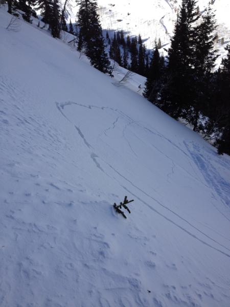
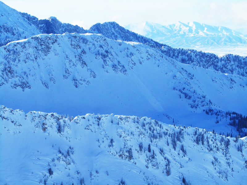
Perhaps what concerns me most is what happened two days ago. To be sure, the north and westerly winds played a role, but those snake-in-the-grass facets from early January showed their hand once again. This in not verified, but it's my suspicion. Photos below, Miller Hill (northerly at 9500') area south of Snowbird (1st pic), and high east facing Maybird (Konigsberg pic from a distance). Both reports involved cracking and collapsing prior to release. Note the Miller Hill avalanche did not run...
Yesterday yielded a couple 1' deep and 50' wide wind slabs triggered by explosives and a couple shallow wet slabs triggered by skiers exiting down the south facing Emma Ridges into LCC in the afternoon. These were roughly 5" deep and 20' wide, running over 300' down the gulley.
Wet Snow
Description
Feels like spring. Shallow wet sluffs and wet slabs will be more problematic today with direct sun and daytime highs reaching the low 40s. Long wave radiational cooling and overnight lows in the teens and 20s will have left a good frozen crust on the steeper sunny aspects; still - plan your exits and timing with care. It'll be likely you can trigger more wet unconsolidated snow if moving through the steeper terrain by midday on the east facing slopes and late afternoon on south and westerlies. If you find yourself up to your boot-tops or riding through sloppy unconsolidated wet snow, change aspects or slope angle. Graceful and timely exits are the ticket for today.
Persistent Weak Layer
Description
Old and new wind drifts may still be triggered in open lee terrain today and most pronounced on steeep northeast through south facing slopes. These will be isolated and pockety though still worth a mention if traveling into the alpine today.
Loose Dry Snow
Description
These are the days you wish for the old "pockets" - the little dots on the map so as to not over emphasize how likely it may be to trigger one and widespread they are, They're perhaps most pronounced in the north through easterly terrain above about 8500'. Odds are low to trigger one; confidence in where trigger points are is as well. See recent activity above for more details.
Additional Information
The bluebird will sing today. Temps will rise into the low 40s at 10,000' and near freezing at 10,000'. The westerly winds are expected to be in the 20mph range with occasionally higher averages and gusts along the highest peaks and ridgelines. A weak cold front grazes by to the north tomorrow, dropping temps back to the low teens in the afternoon. We may see a trace and a half out of it before high pressure builds back in for Monday. A large Pacific storm moves into the region Tuesday with continued storms through the rest of the week and through the weekend. I would hesitate to imply heavy snowfall...just prolonged snowfall over that 7 day period...Stay tuned.
General Announcements
Go to http://www.backcountry.com/utah-avalanche-center to get tickets from our partners at Park City, Beaver Mountain, Canyons, Sundance, and Wolf Mountain. All proceeds benefit the Utah Avalanche Center.
If you trigger an avalanche in the backcountry - especially if you are adjacent to a ski area – please call the following teams to alert them to the slide and whether anyone is missing or not. Rescue teams can be exposed to significant hazard when responding to avalanches, and do not want to do so when unneeded. Thanks.
Salt Lake and Park City – Alta Central (801-742-2033), Canyons Resort Dispatch (435-615-3322)
Ogden – Snowbasin Patrol Dispatch (801-620-1017)
Powder Mountain Ski Patrol Dispatch (801-745-3772 ex 123)
Provo – Sundance Patrol Dispatch (801-223-4150)
Dawn Patrol Forecast Hotline, updated by 05:30: 888-999-4019 option 8.
Twitter Updates for your mobile phone - DETAILS
Daily observations are frequently posted by 10 pm each evening.
Subscribe to the daily avalanche advisory e-mail click HERE.
UDOT canyon closures UDOT at (801) 975-4838
Wasatch Powderbird Guides does daily updates about where they'll be operating on this blog http://powderbird.blogspot.com/ .
Remember your information can save lives. If you see anything we should know about, please participate in the creation of our own community avalanche advisory by submitting snow and avalanche conditions. You can also call us at 801-524-5304 or 800-662-4140, or email by clicking HERE
Donate to your favorite non-profit –The Friends of the Utah Avalanche Center. The UAC depends on contributions from users like you to support our work.
For a print version of this advisory click HERE.
This advisory is produced by the U.S. Forest Service, which is solely responsible for its content. It describes only general avalanche conditions and local variations always exist. Specific terrain and route finding decisions should always be based on skills learned in a field-based avalanche class.