

Forecast for the Uintas Area Mountains

Saturday morning, February 16, 2013
A MODERATE avalanche danger is found on steep, wind drifted mid and upper elevation terrain and human triggered avalanches are possible, especially on southerly facing slopes.
In addition, there's a MODERATE danger of triggering an avalanche that breaks into deeper buried weak layers, particularly on steep shady slopes facing the north half of the compass.
LOW avalanche danger is found on low angle, wind sheltered terrain, where there are no steep slopes above or adjacent to where you're riding.
 Special Announcements
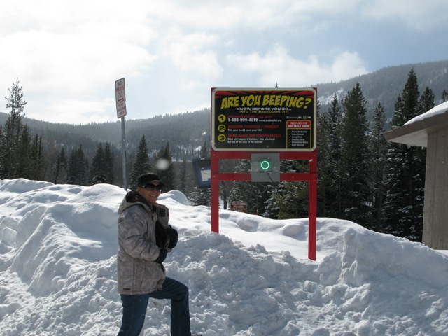
We installed the BCA Beacon Checker at the Soapstone Trailhead yesterday. Here, a beautiful local rider, checks that her avalanche beacon is working properly prior to getting out on the snow.
 Weather and Snow
High pressure is building, giving us clear skies and slightly inverted temperatures. Currently it's in the mid teens at the trailheads and low 20's along the ridges. West-northwest winds are blowing 20-30 mph with a few gusts in the low 40's along the highest peaks. Riding and turning conditions are a bit of a mixed bag up high, but once you're in wind sheltered terrain there's soft creamy snow awaiting your arrival.
Recent observations can be found here.
Wondering why last winter was so crazy? Click here to watch the 2011-12 Utah Winter Review... an excellent recap of last years conditions.
 Recent Avalanches

This wind slab was triggered yesterday on the steep east-southeast face of Currant Creek Peak.

Persistent Weak Layer
Description
West and northwest winds have been blowing in the 20's and 30's along the high ridges since early in the week and they've found plenty of light snow to whip into stout, hard, wind drifts. The vast majority of today's slabs are found on upper elevation, leeward slopes with a south or easterly component to their aspect... however, it's not all that straight forward. Adding a tricky variable to the mix are chutes and gullies facing the north half of the compass that have been cross loaded. Today's wind drifts may be a bit more stubborn, but they'll pack a punch and can easily end your season, especially in steep, unforgiving terrain. The hot ticket is to avoid fat looking rounded pillows of snow, especially if they sound hollow like a drum.
New Snow
Description
We might've forgotten about them, but our problem child, the January facets, aren't going away anytime soon. As a matter of fact they've been having a great time partying in our shallow snowpack, growing weak and sugary, and getting cranky when we tease them. While not widespread, avalanches breaking into this nefariously tricky weak layer aren't out of the question. It's counter-intuitive, but some of our weakest snow is found mid slope in steep, shady terrain. Best way to avoid getting tricked is to tone your slope angles down and think about not only the snow you're riding in, but also the snow you're riding on. Strong snow on weak snow is a dangerous combination and it allows us to get well out onto the slope before triggering a slide. If you feel the bottom falling out from under your machine and you're track is sinking into weak sugary snow that's a big red flag.
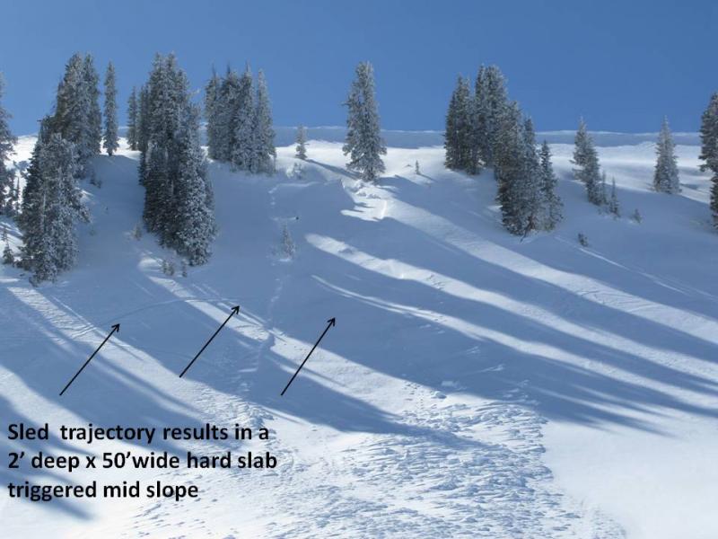
While not huge, this slide clearly shows the January facets still alive and well. This slide was triggered on the 13th on a steep north facing slope in upper Whitney Basin at about 10, 400' in elevation.
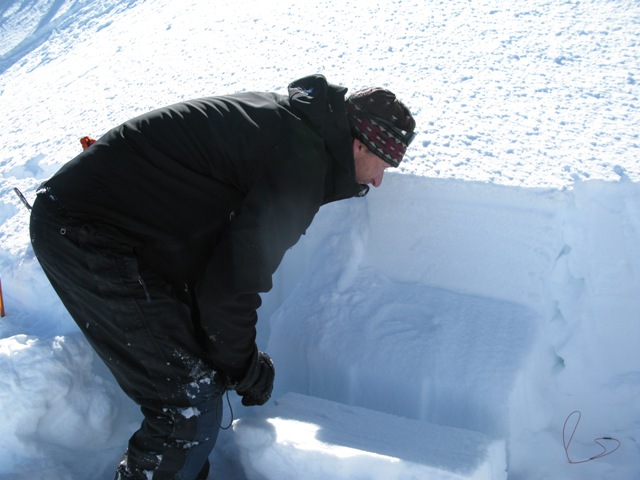
If you ever have questions about avalanche conditions on the North Slope... hit this guy up. Ted Scroggin know the place like no other. Here Ted takes a look at our pit results which failed on the January facets. Our ECT column propagated with 22 taps, producing a Q1 shear.
Additional Information
Today we can expect sunny skies with continued west-northwest winds in the 20's and 30's along the ridges. Temperatures will be mild, climbing into the upper 30's before dipping into the teens overnight. High pressure quickly moves to our east tonight allowing a quick hitting, though mostly dry cold front to slide through the region. A few flurries and cooler temperatures are on tap for Sunday before high pressure returns briefly on Monday. A broad trough is scheduled to homestead over the region beginning late Tuesday night and should linger through most of the week giving us a decent shot of snow.
General Announcements
Remember your information can save lives. If you see anything we should know about, please participate in the creation of our own community avalanche advisory by submitting snow and avalanche conditions. You can call me directly at 801-231-2170, email [email protected], or email by clicking HERE
This is a great time of year to schedule a free avalanche awareness presentation for your group or club. You can contact me at 801-231-2170 or email [email protected]
Donate to your favorite non-profit –The Friends of the Utah Avalanche Center. The UAC depends on contributions from users like you to support our work.
The information in this advisory is from the US Forest Service which is solely responsible for its content. This advisory describes general avalanche conditions and local variations always occur.
The information in this advisory expires 24 hours after the date and time posted, but will be updated by 7:00 AM Sunday February 17th.