

Forecast for the Ogden Area Mountains
Friday morning, February 15, 2013
Avoid: slopes steeper than 33 degrees with recent wind deposits, which will look smooth and rounded.
Normal Caution: for wet, loose snow avalanches or shallow, sun-induced slabs on steep sun exposed slopes today.
Also, for lingering persistent slabs on shady aspects especially in thin snowpack areas.
 Special Announcements
I created some interesting charts from the avalanches so far this season, which you can find on my Blog from yesterday. In summary, most of our avalanches occur on northeast facing slopes, between 9,000 to 10,000', with faceted snow as the weak layer and on slopes between 34 and 45 degrees.
 Weather and Snow
It was mostly clear overnight but some mountain top stratus clouds arrived this morning, which will hang around the mountains at times again today. It was cold overnight. The winds were moderate overnight from the north and northwest and they have picked up to 30 and should be moderate to strong again today from the northwest.
There is still good riding conditions on the sun and wind sheltered slopes with 6-8 inches of dense, fast snow with graupel on top. Sun exposed slopes have a sun crust and the upper elevation, wind exposed terrain is wind damaged.
 Recent Avalanches
Not much activity reported yesterday. But someone reported a skier triggered wind slab yesterday, with no one caught, from Maybird on the chute south of the Obelisk, which was 8 inches to 4 feet deep. Unknown width, aspect, elevation, etc. We would love to have more information.
Our forecaster, Drew Hardesty had a good observation from the Alta perimeter which showed wind loading and some shallow wind and sun triggered slides.
Another party reported collapsing with a nice crack, but no avalanche, lower on Miller Hill. From the looks of it, there must have been faceted snow underneath.

Persistent Weak Layer
Description
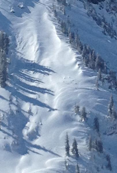
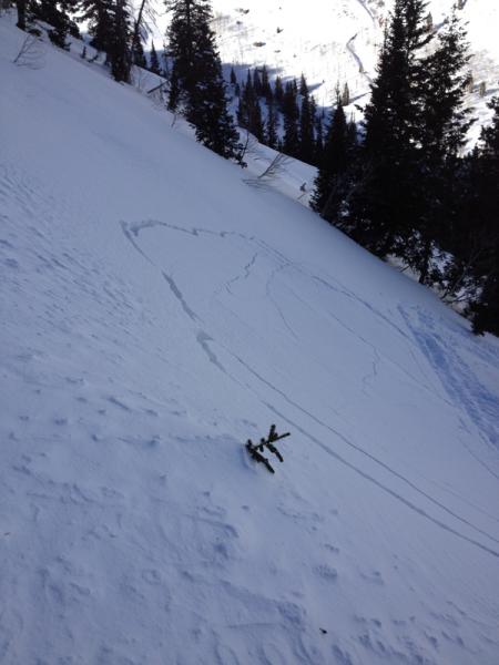
Moderate to strong northwest winds for the past couple days--plus more today--have deposited wind drifted snow onto downwind terrain. These wind slabs are mostly hard and stiff and occasionally thick, as evidenced by the Maybird slide from yesterday. As usual, avoid steep slopes with recent wind drifts, which you can recognize by their smooth, rounded shape. See Drew's great example from yesterday. Notice the shape and the snow surface texture. The ability to recognize and avoid wind slabs is an essential skill for anyone traveling in the backcountry. Learn this lesson well.
Some of these may rest on faceted snow, which is a persistent weak layer so they may last for awhile.
Wet Snow
Description
With warming temperatures today we may see some wet loose avalanches and perhaps some shallow slabs caused by sun warming on the sun exposed slopes. Wet activity my get delayed by the stratus clouds and wind but Saturday, the problems should be worse.
Loose Dry Snow
Description
Although the persistent or deep slabs seem mostly dormant, we can never forget about them. They are called persistent because, well, they are persistent. One party collapsed a slope yesterday on Miller Hill around 9,500' on a north facing slopes. This likely failed on buried faceted snow and it indicates that with the increased traffic expected this weekend, someone may be able to find one of these sleeping dragons.
Additional Information
We have a stronger jet over us today from the north and winds have picked up in the wind exposed terrain. Expect 30-40 mph winds on the high peaks from the northwest. Temperatures should warm up to near freezing again at 8,000' and near 20 along the ridge tops. We also have some localized stratus clouds hanging around the mountain tops again today, which should come and go. These might cause a bit of rime as well above about 10,000'
Saturday should be mostly sunny and warm with temperatures just above freezing. By Sunday, we have a weak disturbance, which will probably produce some brief snow and wind. Otherwise we will have to wait for a stronger, closed low system for Wednesday through the end of the week, that looks a lot like the storm we had last week.
General Announcements
Go to http://www.backcountry.com/utah-avalanche-center to get tickets from our partners at Park City, Beaver Mountain, Canyons, Sundance, and Wolf Mountain. All proceeds benefit the Utah Avalanche Center.
If you trigger an avalanche in the backcountry - especially if you are adjacent to a ski area – please call the following teams to alert them to the slide and whether anyone is missing or not. Rescue teams can be exposed to significant hazard when responding to avalanches, and do not want to do so when unneeded. Thanks.
Salt Lake and Park City – Alta Central (801-742-2033), Canyons Resort Dispatch (435-615-3322)
Ogden – Snowbasin Patrol Dispatch (801-620-1017)
Powder Mountain Ski Patrol Dispatch (801-745-3772 ex 123)
Provo – Sundance Patrol Dispatch (801-223-4150)
Dawn Patrol Forecast Hotline, updated by 05:30: 888-999-4019 option 8.
Twitter Updates for your mobile phone - DETAILS
Daily observations are frequently posted by 10 pm each evening.
Subscribe to the daily avalanche advisory e-mail click HERE.
UDOT canyon closures UDOT at (801) 975-4838
Wasatch Powderbird Guides does daily updates about where they'll be operating on this blog http://powderbird.blogspot.com/ .
Remember your information can save lives. If you see anything we should know about, please participate in the creation of our own community avalanche advisory by submitting snow and avalanche conditions. You can also call us at 801-524-5304 or 800-662-4140, or email by clicking HERE
Donate to your favorite non-profit –The Friends of the Utah Avalanche Center. The UAC depends on contributions from users like you to support our work.
For a print version of this advisory click HERE.
This advisory is produced by the U.S. Forest Service, which is solely responsible for its content. It describes only general avalanche conditions and local variations always exist. Specific terrain and route finding decisions should always be based on skills learned in a field-based avalanche class.