Forecast for the Uintas Area Mountains

Wednesday morning, February 13, 2013
A MODERATE avalanche danger is found on steep, wind drifted mid and upper elevation terrain and human triggered avalanches are possible, especially on southerly facing slopes.
In addition, there's a MODERATE danger of triggering an avalanche that breaks into deeper buried weak layers, particularly on steep shady slopes facing the north half of the compass.
LOW avalanche danger is found on low angle, wind sheltered terrain, where there are no steep slopes above or adjacent to where you're riding.
 Special Announcements

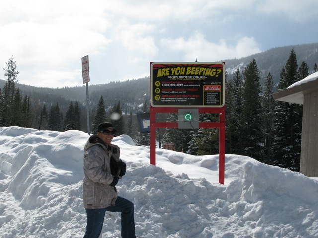
We installed the BCA Beacon Checker at the Soapstone Trailhead yesterday. Here, a beautiful local rider, checks that her avalanche beacon is working properly prior to getting out on the snow.
 Weather and Snow
Mostly cloudy skies and a moist, northerly flow brought an additional 2" of new snow to the region yesterday. Temperatures are in the upper single digits and low teens. Northerly winds have been blowing since late Monday, with hourly averages in the teens and low 20's, gusting to 40 mph along the most exposed peaks. A go-anywhere-supportable base, combined with ultra-light chin tickling surface snow... it's about as good as it gets for the eastern front.
Recent observations can be found here.
Wondering why last winter was so crazy? Click here to watch the 2011-12 Utah Winter Review... an excellent recap of last years conditions.
 Recent Avalanches
Shallow soft slabs and sluffing on sustained steep slopes are about the only avalanche activity we've seen or heard about.
Persistent Weak Layer
Description
Light density snow and sustained northerly winds have conspired to form sensitive wind drifts along the leeward side of upper elevation ridges. The vast majority of today's fresh drifts are found on upper elevation wind loaded slopes facing in the south half of the compass. While mostly manageable in size and predictably breaking at or below your skis, board, or sled, take care that you don't underestimate the power of the avalanche dragon you're dealing with, especially if you match it with steep, unforgiving terrain.
New Snow
Description
It's been nearly two weeks since we've heard of any avalanche activity breaking into the January facets, now buried several feet deep. Good news for sure, but I'm not ready to turn my back on this persistent buried weakness. While isolated, avalanches breaking deeper and wider than you might expect can still be triggered, especially in steep, complex terrain. If your travels take you into terrain with these characteristics today, carefully assess the snowpack and consider the consequences of triggering a slide.
Additional Information
Mostly cloudy skies, light snow, and temperatures warming into the upper 20's are all on tap as the region remains in a very moist, yet warm, northwesterly flow. West and northwest winds are gonna be a nuisance, blowing 20-30 mph with an occasional gust in the 40's along the high peaks. A slightly stronger system works into the region late tonight and should linger into Thursday morning. Not a big storm, but enough energy to produce a couple inches of snow. Yet another weak system slides through Thursday night before high pressure builds for the early portion of the weekend. Computer models hint at a large, cold storm for midweek.
General Announcements
Remember your information can save lives. If you see anything we should know about, please participate in the creation of our own community avalanche advisory by submitting snow and avalanche conditions. You can call me directly at 801-231-2170, email [email protected], or email by clicking HERE
This is a great time of year to schedule a free avalanche awareness presentation for your group or club. You can contact me at 801-231-2170 or email [email protected]
Donate to your favorite non-profit –The Friends of the Utah Avalanche Center. The UAC depends on contributions from users like you to support our work.
The information in this advisory is from the US Forest Service which is solely responsible for its content. This advisory describes general avalanche conditions and local variations always occur.
The information in this advisory expires 24 hours after the date and time posted, but will be updated by 7:00 AM Saturday February 16th.


