

Forecast for the Logan Area Mountains

Saturday morning, February 9, 2013
There is a MODERATE (level 2) danger in the backcountry. Heightened avalanche conditions exist, and you might trigger large unmanageable and potentially deadly avalanches on isolated slopes. Shallow, mostly manageable wind slab avalanches are possible in drifted upper elevation terrain, and triggered loose sluffs involving fresh snow may become likely in steep terrain. Evaluate the snow and terrain carefully, use safe travel protocols, and make conservative decisions regarding your route.
 Weather and Snow
The Tony Grove Snotel at 8400' reports 4 inches of new snow overnight with 4/10ths of an inch of water. It's 19 degrees, there is 58 inches of total snow, and 66% of average water content for the date. It's 13 degrees at the CSI Logan Peak weather station, and south winds leveled off overnight, with 10 mph hourly average wind speeds currently. You'll find shallow powder on a mostly supportable base in the backcountry.
 Recent Avalanches
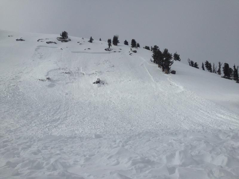
Locally; Riders remote triggered a large and dangerous avalanche in a popular area above the Tony Grove Lake Campground over the weekend, I think on Sunday. The unreported 2' deep avalanche on a steep north-northeast facing slope at around 8400' in elevation was at least 250' wide, and it ran violently through thick trees down into the campground. Link HERE. and check out the video. A party of riders on Wednesday encountered a large recent hard slab avalanche in Christmas Tree Bowl just north of Naomi Peak. The 3' deep and 200' wide avalanche was on a southeast facing slope at around 9500' in elevation. ..... click HERE
Here's a link to our updated Avalanche List.

New Snow
Description
Avalanches might fail 1 to 3 feet deep on weak faceted snow created during the drawn-out January high pressure systems. The danger is pockety, meaning many slopes are fairly stable, but slopes with unstable snow exist and are interspersed. In these conditions, you could trigger avalanches in some areas remotely, from a distance or worse, from below. Audible collapsing or whumpfing, recent avalanches, and cracking are red flags indicating instability... I found faceted snow at all elevations yesterday, but my pit tests showed slab propagation only in a couple areas. A new load from the incoming storm might reactivate the now deeply buried January weak layer, and the danger of deep slab avalanches could increase over the weekend depending on the snow quantities.
New Snow
Description
Shallow fresh wind slabs formed in exposed upper elevation terrain with last night's moderate south winds. These should be of the manageable variety today, but as usual it's best to avoid fresh drifts on steep slopes, and watch for potential wind slabs in and around terrain features like sub-ridges, gullies, and cliff bands. Drifts can appear chalky, rounded or bulging, and can sound hollow or drum-like.
Loose avalanches or sluffs involving the fresh snow are possible and may become likely on steep slopes with significant accumulations today....
Additional Information
The National Weather Service has continued a Winter Storm Warning through late Sunday night. A closed low is slowly moving across the state, and a long duration snow event will bring heavy snow to the mountains and periods of heavy snow to the valleys as well. There will be breaks in the snowfall, but most areas in the state will be affected by this storm. 1 to 2 feet of accumulation is possible in the mountains... Expect southwest winds to become light and variable today, temperatures will be in the mid twenties, and 3 to 5 inches of accumulation is expected during the day. The wind will shift around from the northwest tonight, and begin to intensify. 2 to 4 inches of snowfall is forecast. Northwest winds will be fairly strong tomorrow and a few more inches of snow is likely...
Check out the new Logan Mountain Weather page...
General Announcements
The infamous annual CROWBAR backcountry ski race is scheduled for Saturday, February 23 in Beaver Creek Canyon. Click HERE for more details...
For a printer friendly version of this advisory click HERE
Remember your information from the backcountry can save lives. If you see or trigger an avalanche, or see anything else we should know about, please send us your snow and avalanche observations. You can also call us at 801-524-5304 or email by clicking HERE. In the Logan Area you can contact Toby Weed directly at 435-757-7578.
I will update this advisory on Monday, Wednesday, Friday, and Saturday mornings by around 7:30...
This advisory is produced by the U.S.D.A. Forest Service, which is solely responsible for its content. It describes only general avalanche conditions and local variations always exist.