

Forecast for the Ogden Area Mountains

Saturday morning, February 9, 2013
A very pockety MODERATE avalanche danger remains on the mid and upper elevation northwest through north through easterly facing slopes for human triggered slides 1-3' deep. Shallow loose snow avalanches are wind drifts in the high northerly terrain may again be possible with additional snow this afternoon.
 Weather and Snow
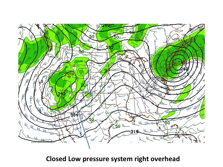
Far from the perfect storm. The south to southeast winds picked up yesterday ahead of the storm, blowing 20-25mph with gusts to 30...temps plummeted to the single digits and low teens. The initial band of snowfall came in fast and furious in the early afternoon, but lost steam just as quickly. Easy come, easy go. Weather geeks (yes, I belong to that club as well), often are apprehensive with these weather systems where the "closed circulation" storm moves overhead - all the energy circulates along the perimeter of the "circle" with little lift in the center to generate snowfall. Oh well...the storm should saunter a bit east today and we'll be along the perimeter again...and we'll see some additional snowfall.
As it was, the Provo mountains picked up 8-11" and the Cottonwoods picked up 4-6" yesterday; the Park City and Ogden mountains a few inches less. Skies are partly cloudy, temps in the upper single digits/low teens and winds are southwesterly and generally less than 15mph. Riding conditions improved with this Colorado blockbuster (apologies to friends to the east).
 Recent Avalanches
Little to report other than some shallow wind drifts noted in the high northerly terrain. Poor initial bonding of the new snow (accentuated by the heavy snowfall rates) allowed for some sluffing of the new in the steeper northerly terrain. No cracking or collapsing noted in the weak mid-pack of January facets and squares.

New Snow
Description
The outlier. I suspect that if we picked up a couple feet of snow with stronger winds we'd have enough to reactivate these January weaknesses buried 1-3' down...but I don't think we'll pick up that much. Until then, except in isolated terrain, the persistent slab will be an anomaly. Snow stability test scores still indicate a wide range of results - enough for me to choose northerly terrain with few consequences (terrain traps, cliff bands, etc).
New Snow
Description
We should see additional snowfall by the early afternoon into tomorrow. The new snow should bond well to yesterday's few inches...though in the unlikely event of high rates of snowfall or strong winds, the storm snow avalanche danger will be on the rise. I recorded a few thoughts on terrain traps and new snow/old snow interfaces yesterday enroute the Big Cottonwood/Mill Creek ridgeline.
Additional Information
As the storm moves a bit to the east, we'll see wrap-around moisture coming in on a north to northwest flow...and we may see 3-5" through the evening and perhaps the same overnight through tomorrow. Confidence level on snow amounts is fair. Temps will be in the single digits to low teens up high, the mid teens at the mid elevations. Winds move counter clockwise around the center of the storm...and winds will begin to veer to the north, perhaps northwest but remain light to moderate....High pressure noses in from the west and we'll stay under a cool northerly flow with the occasional embedded disturbance through the week.
General Announcements
Go to http://www.backcountry.com/utah-avalanche-center to get tickets from our partners at Park City, Beaver Mountain, Canyons, Sundance, and Wolf Mountain. All proceeds benefit the Utah Avalanche Center.
If you trigger an avalanche in the backcountry - especially if you are adjacent to a ski area – please call the following teams to alert them to the slide and whether anyone is missing or not. Rescue teams can be exposed to significant hazard when responding to avalanches, and do not want to do so when unneeded. Thanks.
Salt Lake and Park City – Alta Central (801-742-2033), Canyons Resort Dispatch (435-615-3322)
Ogden – Snowbasin Patrol Dispatch (801-620-1017)
Powder Mountain Ski Patrol Dispatch (801-745-3773 ex 123)
Provo – Sundance Patrol Dispatch (801-223-4150)
Dawn Patrol Forecast Hotline, updated by 05:30: 888-999-4019 option 8.
Twitter Updates for your mobile phone - DETAILS
Daily observations are frequently posted by 10 pm each evening.
Subscribe to the daily avalanche advisory e-mail click HERE.
UDOT canyon closures UDOT at (801) 975-4838
Wasatch Powderbird Guides does daily updates about where they'll be operating on this blog http://powderbird.blogspot.com/ .
Remember your information can save lives. If you see anything we should know about, please participate in the creation of our own community avalanche advisory by submitting snow and avalanche conditions. You can also call us at 801-524-5304 or 800-662-4140, or email by clicking HERE
Donate to your favorite non-profit –The Friends of the Utah Avalanche Center. The UAC depends on contributions from users like you to support our work.
For a print version of this advisory click HERE.
This advisory is produced by the U.S. Forest Service, which is solely responsible for its content. It describes only general avalanche conditions and local variations always exist. Specific terrain and route finding decisions should always be based on skills learned in a field-based avalanche class.