

Forecast for the Uintas Area Mountains

Wednesday morning, February 6, 2013
At and above treeline pockets of CONSIDERABLE avalanche danger exist today and dangerous human triggered avalanches are likely, especially on steep wind drifted slopes with an easterly component to their aspect.
A MODERATE avalanche danger is found on steep, wind drifted mid elevation terrain and human triggered avalanches are possible.
LOW avalanche danger is found on low angle, wind sheltered terrain, where there are no steep slopes above or adjacent to where you're riding .
 Special Announcements
Come join us Friday night Feb. 8th at Big Pine Sports in Fairview at 6:00 for a free avy presentation by sledders... for sledders
 Weather and Snow
Overnight, clouds thickened as a weak cold front slid through the region, dropping temperatures into the upper teens and low 20's. Gusty southwest winds switched to the west-northwest at 4:00 this morning and they're currently blowing 15-20 mph along the high ridges. Riding and turning conditions are a bit worn out, but the clean air and big, brigh,t beautiful sun will make getting on the snow worth the trip.
Recent observations can be found here.
Wondering why last winter was so crazy? Click here to watch the 2011-12 Utah Winter Review... an excellent recap of last years conditions.
 Recent Avalanches
Over the past few days news has trickled in of multiple human triggered avalanches along with a few close calls over the weekend. I'm certainly grateful for all the info and updates... please keep 'em coming. However, if you could let us know the details the day of the slide it helps us to issue more accurate forecasts and ultimately keeps more riders safe.
Ted was all over the map yesterday chasing down slides. His observations can be found here.
An update on last weeks close call at Monte Cristo is found here.
An accident report detailing the very tragic avalanche in the West Fork of the Duchesne can be found here.

New Snow
Description
The dust has settled since the weekend and I haven't heard about any new slides breaking deep into the buried and now preserved January facets. The good news is... many slopes are good to go and offer green light conditions. But the other side of the coin offers slopes just waiting for a trigger to come along and knock the legs out from underneath them. Our problem child is a weak, sugary layer formed during the early January dryspell which is now buried several feet deep under last weeks storm snow. While this weakness is starting to adjust to all the added weight of snow and wind, persistent buried weak layers like we're dealing with now, trick even the most experienced avalanche people and our current setup is no different. Patience is the key right now. Even though riders are getting onto many steep slopes without incident the avalanche conditions are hovering in the low probability, high consequence category. In other words... I wouldn't go to Vegas with those odds and I'm definitely not going to bet my life with those odds stacked against me. It doesn't mean you can't ride. It does mean you need to carefully evaluate your terrain choices and consider the consequences of triggering a slide. Low angle slopes offer great riding and reward with little risk... not a bad way roll today.
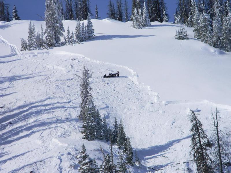
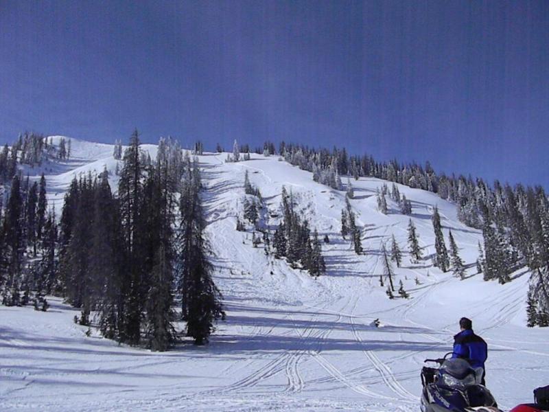
This slide on Currant Creek Peak illustrates the depth of the sleeping avalanche dragon. While they're getting harder to initiate, avalanches triggered on steep wind drifted slopes can break deeper and wider than you might expect.
Persistent Weak Layer
Description
A few tired, old wind slabs may be found along the ridges, but they're becoming less likely to trigger. However, don't get tricked into thinking this is the only avalanche game in town. A manageable wind drift could quickly get out of hand, especially if it breaks into weaker layers of the snowpack as it crashes down on the slope below.
Additional Information
Clouds thin out as the day wares on and we should see mostly sunny skies by late morning. High temperatures reach into the low 30's before dipping into the teens and single digits tonight. Thursday brings increasing southerly winds and warmer temperatures as a storm system starts moving towards the state for the weekend. Snow should begin late Friday and continue through early Sunday with about a foot of new snow expected.
General Announcements
Remember your information can save lives. If you see anything we should know about, please participate in the creation of our own community avalanche advisory by submitting snow and avalanche conditions. You can call me directly at 801-231-2170, email [email protected], or email by clicking HERE
This is a great time of year to schedule a free avalanche awareness presentation for your group or club. You can contact me at 801-231-2170 or email [email protected]
Donate to your favorite non-profit –The Friends of the Utah Avalanche Center. The UAC depends on contributions from users like you to support our work.
The information in this advisory is from the US Forest Service which is solely responsible for its content. This advisory describes general avalanche conditions and local variations always occur.
The information in this advisory expires 24 hours after the date and time posted, but will be updated by 7:00 AM Saturday February 9th.