

Forecast for the Uintas Area Mountains

Friday morning, February 1, 2013
At and above treeline a CONSIDERABLE avalanche danger exists today and deep, dangerous human triggered avalanches are likely. Within this terrain, pockets of HIGH avalanche danger is found, especially on steep wind drifted slopes with an easterly component to their aspect.
A MODERATE avalanche danger is found on steep, wind drifted mid elevation terrain and human triggered avalanches are possible.
LOW avalanche danger is found in terrain where there are no steep slopes above or adjacent to where you're riding .
 Weather and Snow
Skies are starting to clear as the moist northwest flow we've been under for the past few days begins marching towards the east. Westerly winds have finally relaxed and they're blowing 15-25 mph along the high peaks. Temperatures are in the upper teens and low to mid 20's. Surface snow remains excellent especially in wind sheltered terrain where soft, settled, creamy powder is found.
Both Ted Scroggin and JG have been killin' it lately with solid Uinta info. Thanks guys for all the great trip reports this year. Recent observations can be found here.
Wondering why last winter was so crazy? Click here to watch the 2011-12 Utah Winter Review... an excellent recap of last years conditions.
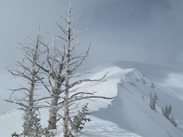
This image pretty much sums it up... cornices have grown in the past few days, north facing terrain is wind loaded and fat, and the Uintas are white.
 Recent Avalanches
Shallow soft slabs, breaking about a foot deep seem to be the common theme.
An accident report detailing the very tragic avalanche in the West Fork of the Duchesne can be found here.

New Snow
Description
Trent and I stomped around Weber Canyon yesterday and quite frankly, we expected to see a lot more natural avalanche activity. While the snowpack remained defiantly strong through the big storm, the basic structure is suspect and can't be trusted. Snow depths and strength are all over the map and some slopes are good to go... others not. Avalanche conditions will be tricky the next few days and it's gonna take some detective work to determine if a slope has green light or red light conditions. One thing for sure- once triggered, today's avalanches will be dangerous, breaking deeper and wider than you might expect. Low angle slopes not connected to steep terrain above you along with terrain facing the south half of the compass will be the ticket. With these great riding options available, you can avoid avalanches altogether and have a blast today.
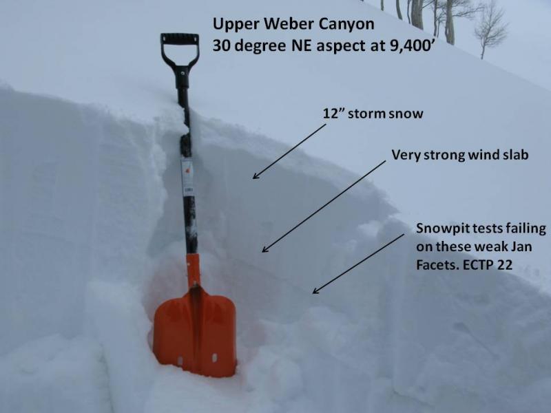
Here's the basic setup in wind loaded terrain facing the north half of the compass.
Persistent Weak Layer
Description
Fresh wind slabs are the most obvious avalanche problem today, but don't get tricked into thinking this is the only avalanche dragon out there. An easily triggered soft slab can quickly get out of hand, especially if it breaks into weaker layers of the snowpack as it crashes down on the slope below.
Cornice
Description
Cornices have grown and will break further back than you might expect. Best to steer clear of these unpredictable pieces of snow.
Additional Information
Sunny skies, temperatures warming into the low 30's, and decreasing winds are on tap the next few days as high pressure builds over the area. Not much change in the pattern until possibly next weekend.
General Announcements
Remember your information can save lives. If you see anything we should know about, please participate in the creation of our own community avalanche advisory by submitting snow and avalanche conditions. You can call me directly at 801-231-2170, email [email protected], or email by clicking HERE
This is a great time of year to schedule a free avalanche awareness presentation for your group or club. You can contact me at 801-231-2170 or email [email protected]
Donate to your favorite non-profit –The Friends of the Utah Avalanche Center. The UAC depends on contributions from users like you to support our work.
The information in this advisory is from the US Forest Service which is solely responsible for its content. This advisory describes general avalanche conditions and local variations always occur.
The information in this advisory expires 24 hours after the date and time posted, but will be updated by 7:00 AM Saturday February 2nd.