

Forecast for the Uintas Area Mountains

Monday morning, January 28, 2013
At and above treeline a CONSIDERABLE avalanche danger exists on steep wind drifted slopes facing the north half of the compass and human triggered avalanches are likely.
LOW avalanche danger is found in most wind sheltered terrain.
 Special Announcements
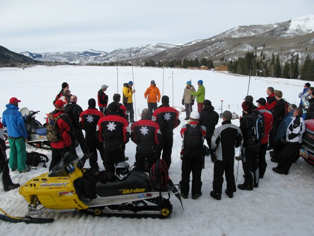
Huge thanks to everyone who attended last weekends Snowmobile Avy Essentials class. The workshop was a huge success with two dozen high end riders participating. It was great to connect with old friends and make some new ones as well.
I couldn't have pulled this off without the support and generosity of Tommy George and Tri-City Performance, Park City Powder Cats, and the expertise offered by an amazing cast of instructors. Making it all happen on the snow side of things- Trent Meisenheimer, Andy VanHouten, Seth Roller, Jason Boyer, Tyler St Jeor, and Cody Hughes.
The riding component was headed up by the top notch skills offered up by Dan Gardiner, Geoff Dyer, Ryan Nelson, and Nick Reedy. You guys are amazing and it was very generous of you to donate your time to provide such a killer class!
 Weather and Snow
Yesterday’s cold front slammed into the Uinta’s just about dinner time, rapidly stacking up 10” of snow around Chalk Creek, 4” near Trial Lake, and about 6” closer to Currant Creek. Skies are mostly cloudy, temperatures are in the single digits and west-northwest winds are blowing 10-15 mph along the high ridges. Riding and turning conditions have vastly improved overnight.
Other observations can be found here.
Wondering why last winter was so crazy? Click here to watch the 2011-12 Utah Winter Review... an excellent recap of last years conditions.
 Recent Avalanches
No new avalanche activity to report.
An accident report detailing the very tragic avalanche in the West Fork of the Duchesne can be found here.

Persistent Weak Layer
Description
South and southwest winds ramped up early Sunday, with hourly averages in the 30’s and gusts in the 60’s and 70’s. Yesterday’s powerful winds rapidly formed fresh slabs which now rest on top of a weak layer of sugary snow formed during the early January dryspell. Problem is… the slab feels strong and solid under our skis, board, or sled allowing us to get out onto the slope before it fails and we trigger an avalanche. Today’s slides will break deeper and wider than you might expect and they’ll be packing a hefty punch. Low angle slopes and terrain facing the south half of the compass will be the ticket. With these great riding options available, you can avoid avalanches altogether and have a blast today… there’s really no reason to pull the dogs tail.
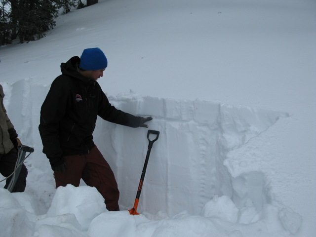
Prior to yesterday's storm, we identified a weak layer of facets that developed during the early January dry spell. Today's avalanches can break into this layer now buried several feet deep in the snowpack.
Cornice
Description
Cornices have grown quite large in the past few days and you should definitely avoid walking out on these unpredictable dragons which have the possibility to break back further than you might expect.
Additional Information
Last night's storm is winding down and we should see scattered snow showers with a little clearing as the day progresses. West and northwest winds remain manageable today and in the 10-20 mph range. Temperatures are gonna be chilly with highs only reaching into the low teens and overnight lows near zero. Westerly winds ramp up late in the day and should gust into the 60's as the next wave of snow moves into the region tonight through Tuesday. This looks like another good shot of snow for the eastern front with snow totals in the 6"-10" range. High pressure builds for the mid to latter part of the week.
General Announcements
Remember your information can save lives. If you see anything we should know about, please participate in the creation of our own community avalanche advisory by submitting snow and avalanche conditions. You can call me directly at 801-231-2170, email [email protected], or email by clicking HERE
This is a great time of year to schedule a free avalanche awareness presentation for your group or club. You can contact me at 801-231-2170 or email [email protected]
Donate to your favorite non-profit –The Friends of the Utah Avalanche Center. The UAC depends on contributions from users like you to support our work.
The information in this advisory is from the US Forest Service which is solely responsible for its content. This advisory describes general avalanche conditions and local variations always occur.
The information in this advisory expires 24 hours after the date and time posted, but will be updated by 7:00 AM Tuesday January 29th.