icon-add
Observation
Menu
×
Menu
Forecasts
Logan
Ogden
Salt Lake
Provo
Uintas
Skyline
Moab
Abajos
Weather
Archives
How to read the forecast
Observations & Avalanches
Submit Observation
Observations Explorer
All Observations
Avalanches
Fatalities
Weather
Place Names Map
Archives
Education
Avalanche Class List
UAC Class List
Online Classes
Resources and Tutorials
Avalanche Awareness
Develop Skills
Events
Store
About
Contact
Who we are
Core Values
Staff
Board of Directors
Past Forecasters
Sponsors
Annual Reports
Sign In
Blog
Donate / Join
Search
Forecasts
Logan
Ogden
Salt Lake
Provo
Uintas
Skyline
Moab
Abajos
Weather
Archives
How to read the forecast
Observations & Avalanches
Submit Observation
Observations Explorer
All Observations
Avalanches
Fatalities
Weather
Place Names Map
Archives
Education
Avalanche Class List
UAC Class List
Online Classes
Resources and Tutorials
Avalanche Awareness
Develop Skills
Events
Store
About
Contact
Who we are
Core Values
Staff
Board of Directors
Past Forecasters
Sponsors
Annual Reports
Sign In
Blog
Menu
Search
icon-add
Observation
Donate / Join
Submit Observation
Observations Explorer
All Observations
Avalanches
Fatalities
Weather
Place Names Map
Archives
Submit Observation
Observations Explorer
All Observations
Avalanches
Fatalities
Weather
Place Names Map
Archives
Observation: Mill Creek Canyon
Observation Date
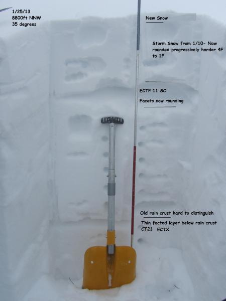
1/25/2013
Observer Name
Konigsberg / Costaschuk
Region
Salt Lake
Location Name or Route
Mill Creek Canyon
Weather
Sky
Overcast
Wind Speed
Calm
Weather Comments
Valley fog to 5000ft? Warm and humid.
Snow Characteristics
New Snow Depth
2"
New Snow Density
High
Snow Surface Conditions
Dense Loose
Damp
Snow Characteristics Comments
Highly variable with elevation. Above 8000ft dense snow, moist but not wet. Snow started to rollerball and pinwheel as soon as you dropped below the 8000ft line. Below 7000ft snowpack isothermic and not supportable to skis.
Red Flags
Red Flags
Rapid Warming
Red Flags Comments
Main red flag is the rapid warming and saturation of previously dry snow below 8000ft. Above 8000ft snowpack structure is improving with lack of temperature gradient but we still have buried faceted layers that could be an issue.
Avalanche Problem #1
Problem
Wet Snow
Trend
Same
Problem #1 Comments
North half of the compass below 8000ft where dry snow has been rapidly warmed. Will be an issue till the cold front comes through Sunday night.
Avalanche Problem #2
Problem
New Snow
Trend
Same
Problem #2 Comments
The warming of the snowpack has lead to a more cohesive slab above the buried facets from early January. The buried facets are gaining strength as the heat added to the snowpack has eliminated any temperature gradient. Although they are gaining strength we still saw that this layer was able to propagate a fracture in stability tests. This layer may be of concern with new snow forecast for Sunday into Monday.