

Forecast for the Uintas Area Mountains

Monday morning, January 21, 2013
At and above treeline pockets of MODERATE avalanche danger exist and human triggered avalanches are possible in steep terrain harboring recent deposits of wind drifted snow.
LOW avalanche danger is found in most wind sheltered terrain.
 Weather and Snow
Skies are clear, temperatures in the upper teens and low 20's, and northerly winds are blowing 20-30 mph with gusts near 40 mph along the high ridges. Protected terrain still offers soft settled powder, but it's becoming a rare commodity.

North and northeast winds have worked the upper elevation terrain, sculpting it into a lunar surface.
Recent observations can be found here.
Wondering why last winter was so crazy? Click here to watch the 2011-12 Utah Winter Review... an excellent recap of last years conditions.
 Recent Avalanches
It is with such a heavy heart and great sadness that I have to report a tragic avalanche related accident which occurred Friday in the West Fork of the Duchesne. Initial reports indicate a cornice broke while three young boys were on it, subsequently burying two of them. Our collective thoughts, prayers, and energy go out to friends and family of the young boys
Many thanks to all the heroic efforts brought forth by all those involved, particularly both Wasatch and Summit County Search & Rescue. We will visit the site today and have a report posted once we sift through the details .
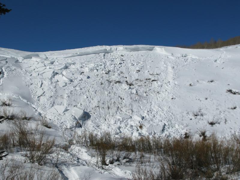
Not a very big slope, just about 50 vertical feet, but the outcome was very sad. A video recapping the details and explaining the avalanche is found here.
In addition, we've posted a preliminary report here.

Persistent Weak Layer
Description
It's been a windy week on the eastern front with north and northeast winds the predominant direction. Gusting into the 60's and 70's midweek, much of the good snow we enjoyed has been stolen and replaced with hard, stiff slabs which formed in unusual locations. While most seem tired and lifeless, there may be an old wind slab or two lurking out there that can serve up and unexpected surprise. Today you'll find these chalky looking, hollow sounding slabs along the leeward side of mid and upper elevation ridges. While most prevalent on slopes facing the south half of the compass, I suspect you'll find an old tired, wind drift or two cross-loaded in upper elevation chutes and gullies as well.
New Snow
Description
The forecast wouldn't be complete without a mention of avalanches breaking into old snow near the ground. While you'd really have to go out of your way to trigger a deep, dangerous slide, should your travels take you into steep, wind loaded, complex terrain you're gonna need to be on your toes. Carefully assess the snowpack and more importantly, think about the consequences of triggering an avalanche.
Additional Information
A ridge of high pressure continues to homestead over the region and we should see sunny skies and temperatures warming into the upper 30's with overnight lows dipping into the low 20's. Winds will generally be out of the northeast averaging 15-25 mph. A weak front crosses the area Wednesday night with cooler temperatures and a chance of snow through Thursday. High pressure returns briefly for Friday. An increasingly moist southwest flow is forecast for the weekend.
General Announcements
Remember your information can save lives. If you see anything we should know about, please participate in the creation of our own community avalanche advisory by submitting snow and avalanche conditions. You can call me directly at 801-231-2170, email [email protected], or email by clicking HERE
This is a great time of year to schedule a free avalanche awareness presentation for your group or club. You can contact me at 801-231-2170 or email [email protected]
Donate to your favorite non-profit –The Friends of the Utah Avalanche Center. The UAC depends on contributions from users like you to support our work.
The information in this advisory is from the US Forest Service which is solely responsible for its content. This advisory describes general avalanche conditions and local variations always occur.
The information in this advisory expires 24 hours after the date and time posted, but will be updated by 7:00 AM Wednesday January 23rd.