Forecast for the Provo Area Mountains

Evelyn Lees
Issued by Evelyn Lees for
Sunday, January 20, 2013

While the avalanche danger is mostly LOW, there are POCKETS of MODERATE danger on slopes steeper than about 35 degrees for the following avalanche problems:

  • Wet loose sluffs can be triggered on steep sunny slopes as the day heats up, first on east, then south, then west
  • Dry loose sluffs can be triggered on steep, shady slopes
  • The hard wind drifts can crack out beneath you on steep slopes, mostly located near the ridgelines or in upper elevation bowls
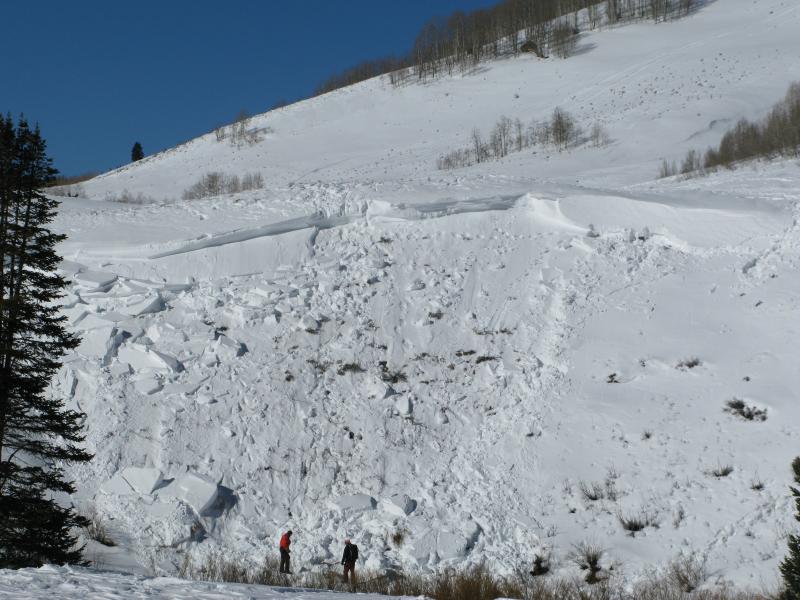
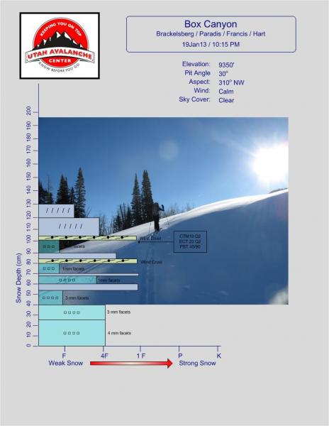
  • There remains an isolated chance of triggering a 1 to 2 foot deep slide on the January facets.

Terrain is critical. If it’s steep it could slide, and there are many places where even a small avalanche can be serious if it takes you off a cliff, into trees, into a terrain trap like a gully or for a long ride in continuously steep terrain

Low
Moderate
Considerable
High
Extreme
Learn how to read the forecast here
Weather and Snow

As January high pressure continues its strangle hold on Utah, the mountains are the place to recreate. It’s another copycat morning of clear, blue skies, with temperatures in the 20s once you get out of the cold canyon bottoms, where there are still some lingering teens and single digits. The northwesterly winds are light, generally less than 15 mph, with a few upper elevation peaks are gusting into the 20’s.

Sunny slopes will be crusted early, and soften with daytime heating, there are spotty old hard wind crusts up high, and soft recrystallized powder capped with sparkly surface hoar on wind sheltered, shady slopes especially at the mid and low elevations. As the snowpack weakens, it is becoming punchy and unsupportable in shallow areas.

Recent Avalanches

From the Wasatch mountains, reports of a few wet sluffs with daytime heating and some cracking of the sun crusts and old hard wind slabs that are sitting on facets.

A report is posted on the Accident Page of the Uinta Mill Hollow fatality – one painful photo tells it all.

Ad
Avalanche Problem #1
Wet Snow
Type
Location
Likelihood
Size
Description

Another warm day will all allow the snow to heat and wet sluffs to be triggered on steep sunny slopes, with even a few natural point releases possible.

Loose, dry sluffs can be triggered on the steep, shady slopes - just large enough to knock you off your feet, or possibly take you for a ride in very steep terrain.

Avalanche Problem #2
Persistent Weak Layer
Type
Location
Likelihood
Size
Description

There are reports of small, hard wind drifts cracking, but not really moving. However, on a steep slope, there are a few large enough to catch and carry you.

Avalanche Problem #3
Loose Dry Snow
Type
Location
Likelihood
Size
Description

It’s the wild card – 2 separate observations from Parley’s canyon drainages made note of poor structure and stability test results where a cohesive slab remains over the January facets. A slide on triggered on the January facets would be a slab avalanche, deep and wide enough to bury a person. This layering is most likely on mid elevation slopes that got heavily loaded in the last storm or areas with denser wind drifted snow.

Additional Information

The mountain weather is just about a “copy and paste” from yesterday - clear skies, temperatures warming into the upper 30s at 8,000’ and into the upper-20s at 10,000’. The northwesterly winds will be light, averaging less than 10 mph at most locations, with only the highest peaks occasionally gusting in the 20s. The mountains will steadily warm over the next 2 days, with 10,000’ temperatures reaching the upper 30s by Tuesday. A weak weather disturbance will bring clouds and cooling Wednesday night into Thursday

General Announcements

Go to http://www.backcountry.com/utah-avalanche-center to get tickets from our partners at Park City, Beaver Mountain, Canyons, Sundance, and Wolf Mountain. All proceeds benefit the Utah Avalanche Center.

If you trigger an avalanche in the backcountry - especially if you are adjacent to a ski area – please call the following teams to alert them to the slide and whether anyone is missing or not. Rescue teams can be exposed to significant hazard when responding to avalanches, and do not want to do so when unneeded. Thanks.

Salt Lake and Park City – Alta Central (801-742-2033), Canyons Resort Dispatch (435-615-3322)

Ogden – Snowbasin Patrol Dispatch (801-620-1017)

Powder Mountain Ski Patrol Dispatch (801-745-3773 ex 123)

Provo – Sundance Patrol Dispatch (801-223-4150)

Dawn Patrol Forecast Hotline, updated by 05:30: 888-999-4019 option 8.

Twitter Updates for your mobile phone - DETAILS

Daily observations are frequently posted by 10 pm each evening.

Subscribe to the daily avalanche advisory e-mail click HERE.

UDOT canyon closures UDOT at (801) 975-4838

Wasatch Powderbird Guides does daily updates about where they'll be operating on this blog http://powderbird.blogspot.com/ .

Remember your information can save lives. If you see anything we should know about, please participate in the creation of our own community avalanche advisory bysubmitting snow and avalanche conditions. You can also call us at 801-524-5304 or 800-662-4140, or email by clicking HERE

Donate to your favorite non-profit –The Friends of the Utah Avalanche Center. The UAC depends on contributions from users like you to support our work.

For a print version of this advisory click HERE.

This advisory is produced by the U.S. Forest Service, which is solely responsible for its content. It describes only general avalanche conditions and local variations always exist. Specific terrain and route finding decisions should always be based on skills learned in a field-based avalanche class