

Forecast for the Uintas Area Mountains

Saturday morning, January 19, 2013
At and above treeline pockets of MODERATE avalanche danger exist and human triggered avalanches are possible. This is most pronounced on steep, wind drifted slopes with a westerly component to their aspect.
LOW avalanche danger is found in most wind sheltered terrain.
 Special Announcements
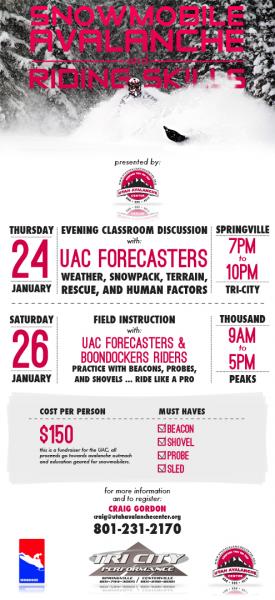
We still have a few slots open. Please join us on Thursday evening, 1/24 and Saturday, 1/26 for a day of learning avalanche and advanced riding skills with Craig & Trent from the Utah Avalanche Center and Dan Gardiner and the Boondockers crew. Details and sign up here
 Weather and Snow
Skies are clear, temperatures in the upper teens and low 20's, and northerly winds are blowing 10-20 mph along the high ridges. Protected terrain still offers soft settled powder, but it's becoming a rare commodity.

Recent winds have worked the upper elevation terrain, sculpting it into a lunar surface.
Recent observations can be found here.
Wondering why last winter was so crazy? Click here to watch the 2011-12 Utah Winter Review... an excellent recap of last years conditions.
 Recent Avalanches
It is with such a heavy heart and great sadness that I have to report a tragic avalanche related accident which occurred yesterday in the West Fork of the Duchesne. Initial reports indicate a cornice broke while three young boys were on it, subsequently burying two of them. Our collective thoughts, prayers, and energy go out to friends and family of the young boys
Many thanks to all the heroic efforts brought forth by all those involved, particularly both Wasatch and Summit County Search & Rescue. We will visit the site today and have a report posted once we sift through the details .

Persistent Weak Layer
Description
North and northeast winds raged into the 70's along the high ridges on Wednesday and early Thursday, forming stiff wind drifts in unusual locations. Yesterday we found these hard slabs to be spotty and a bit lifeless, but we weren't willing to get out onto any big committing terrain to test our theories. Today you'll find these chalky looking, hollow sounding slabs along the leeward side of mid and upper elevation ridges. While most prevalent on slopes facing the south half of the compass, I suspect you'll find an old tired, wind drift or two cross-loaded in upper elevation chutes and gullies as well.
New Snow
Description
The forecast wouldn't be complete without a mention of avalanches breaking into old snow near the ground. While you'd really have to go out of your way to trigger a deep, dangerous slide, should your travels take you into steep, complex terrain you're gonna need to be on your A game. Carefully assess the snowpack and more importantly, think about the consequences of triggering an avalanche.
Additional Information
High pressure is firmly in place and we should see sunny skies, light northerly winds, and temperatures warming into the upper 30's with overnight lows dipping into the low 20's. Only change in the weather is a midweek brush by, but there's not much hope for significant snowfall.
General Announcements
Remember your information can save lives. If you see anything we should know about, please participate in the creation of our own community avalanche advisory by submitting snow and avalanche conditions. You can call me directly at 801-231-2170, email [email protected], or email by clicking HERE
This is a great time of year to schedule a free avalanche awareness presentation for your group or club. You can contact me at 801-231-2170 or email [email protected]
Donate to your favorite non-profit –The Friends of the Utah Avalanche Center. The UAC depends on contributions from users like you to support our work.
The information in this advisory is from the US Forest Service which is solely responsible for its content. This advisory describes general avalanche conditions and local variations always occur.
The information in this advisory expires 24 hours after the date and time posted, but will be updated by 7:00 AM Sunday January 20th.