

Forecast for the Ogden Area Mountains

Wednesday morning, January 16, 2013
A MODERATE danger exists for human triggered slides 1-2' deep on the steep west to north to east facing slopes of all elevations. The danger is most pronounced at the mid-elevations. These avalanches may still be triggered at a distance, particularly with any additional wind loading. The danger associated with wind drifting on steep south to east facing slopes will also be MODERATE...though generally confined to the high ridgelines.
With a building high pressure ridge and warming temps, I anticipate a number of roof-a-lanches over the next several days.
LOW danger – there is plenty of untracked powder left on slopes less steep than about 35 degrees, that are not under or connected to steeper slopes.
 Special Announcements
UDOT will close LCC @ 7am, Wed. 1/16/13 from Gate B to Gate C for artillery data aquisition. Backcountry access will be closed from Lisa Falls through Monte Cristo beginning at midnight tonight. Anticipated re-opening @ 8am.
We have 2 more donated items being sold via auction: Treat yourself and support the UAC and their sponsors.
A day of cat skiing in the Uintas with Park City Powdercats (January or March)

Arva EVO3+ beacon, new in the box. 
 Weather and Snow
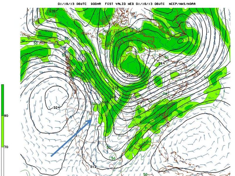
High pressure once again begins its stranglehold over the intermountain west. We have clear skies aloft, moderate to strong northerly winds, and inverted temperatures. A developing and stabilizing air mass tends to squeeze the winds - in Venturi fashion - along, in our case, the 10 to 12,000' level, no more and no less. For you river runners out there, it's a bit like a constriction within the canyon, creating a rapid. The weather chart below - the 700mb GFS model (roughly at 10,000') shows the wind barbs following the black isobars...with the ridge of high pressure centered just off the west coast where it'll park and then move inland and remain for the next week and likely more. In any event, mountain temperatures are in the mid teens; basins and trailhead temps are still in the low single digits.
 Recent Avalanches
Winds played the spoiler yesterday and we had a few reports of some skier triggered wind slabs along the high exposed terrain as well as some shallow natural loose snow avalanches running a couple hundred feet in the steep, south facing confined terrain above Little Cottonwood canyon. By mid-morning a skier high on Little Superior Buttress triggered a 1-2' deep and 100' wide wind slab that reportedly ran 1000' down the slope. Photo by Billy Haas below. (photographer did not initiate the slide). This is on a steep southeast facing slope at 10,300'.


Persistent Weak Layer
Description
36 hours of sustained wind drifting from the northerly winds will have deposited stiffer, perhaps more stubborn 2' deep wind slabs along the lee of the high ridgelines. The wind drifts will be most pronounced on the steep west to south to easterly facing slopes, though recognize that some channelling and cross-loading is likely and you should approach any high alpine avalanche terrain with skepticism. Look for smooth rounded chalky drifts and be aware that they may break out above you today. Continued Shooting cracks will be a clue to localized drifting. Test slopes key as well.
New Snow
Description
The weakest sugary faceted snow from the early January dry spell was most pronounced at the mid to low elevations westerly to northerly to easterly terrain. The greatest snowfall amounts through the 12th fell in the mid to low elevation as well. A touch of wind keeps the high elevations in the game...and the 10 or so slides triggered within this structure demonstrate this well. With the liklihood dropping, it'll be time to be mindful of collapsing, shooting cracks, and pull out the shovel and do the homework. The higher probability spots will - again - be in the thinner areas like Mill Creek, Lambs, Mt Aire, and perhaps the periphery of the Cottonwoods.
Knowledge of the pre-existing snowpack is key in these situations - it hasn't gone unnoticed that many of the old hands have stayed on the southerly aspects - even at the low elevations - avoiding much of the weak snow altogether. Again, slope angle is the great equalizer - slopes less steep than 30 degrees are still great and safe as long as nothing steeper is above
Wind Drifted Snow
Description
Not Low danger...we just don't have a misc icon - loose snow avalanchingand roof-a-lanches will become increasingly problematic over the coming days....Roof-a-lanches are to be taken with some regard. An Alaska avalanche forcaster was killed in 2004 by a roof-a-lanche in the Portage Valley, just southeast of Anchorage and Girdwood.
Additional Information
We'll have clear skies, moderate to strong northerly winds (through midday) and temps warming to the upper 20s at 10,000'. High pressure will dominate the weather pattern for the next couple of weeks...
General Announcements
Go to http://www.backcountry.com/utah-avalanche-center to get tickets from our partners at Park City, Beaver Mountain, Canyons, Sundance, and Wolf Mountain. All proceeds benefit the Utah Avalanche Center.
If you trigger an avalanche in the backcountry - especially if you are adjacent to a ski area – please call the following teams to alert them to the slide and whether anyone is missing or not. Rescue teams can be exposed to significant hazard when responding to avalanches, and do not want to do so when unneeded. Thanks.
Salt Lake and Park City – Alta Central (801-742-2033), Canyons Resort Dispatch (435-615-3322)
Ogden – Snowbasin Patrol Dispatch (801-620-1017)
Powder Mountain Ski Patrol Dispatch (801-745-3773 ex 123)
Provo – Sundance Patrol Dispatch (801-223-4150)
Dawn Patrol Forecast Hotline, updated by 05:30: 888-999-4019 option 8.
Twitter Updates for your mobile phone - DETAILS
Daily observations are frequently posted by 10 pm each evening.
Subscribe to the daily avalanche advisory e-mail click HERE.
UDOT canyon closures UDOT at (801) 975-4838
Wasatch Powderbird Guides does daily updates about where they'll be operating on this blog http://powderbird.blogspot.com/ .
Remember your information can save lives. If you see anything we should know about, please participate in the creation of our own community avalanche advisory bysubmitting snow and avalanche conditions. You can also call us at 801-524-5304 or 800-662-4140, or email by clicking HERE
Donate to your favorite non-profit –The Friends of the Utah Avalanche Center. The UAC depends on contributions from users like you to support our work.
For a print version of this advisory click HERE.
This advisory is produced by the U.S. Forest Service, which is solely responsible for its content. It describes only general avalanche conditions and local variations always exist. Specific terrain and route finding decisions should always be based on skills learned in a field-based avalanche class