

Forecast for the Uintas Area Mountains

Wednesday morning, January 16, 2013
Terrain to avoid- Steep, rocky, upper elevation slopes where human triggered avalanches breaking near the ground are still possible.
At and above treeline a MODERATE avalanche danger exists and human triggered avalanches are possible, especially on steep, wind drifted slopes.
LOW avalanche danger is found in most wind sheltered terrain.
 Special Announcements
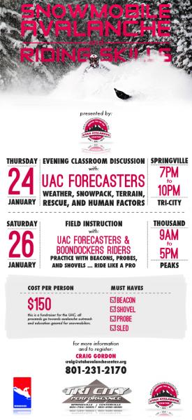
We still have a few slots open. Please join us on Thursday evening, 1/24 and Saturday, 1/26 for a day of learning avalanche and advanced riding skills with Craig & Trent from the Utah Avalanche Center and Dan Gardiner and the Boondockers crew. Details and sign up here
 Weather and Snow
Skies are clearing this morning and temperatures are becoming more Utahesque. Currently, most locations are in the upper teens and low 20's, while the lower elevation trailheads are inverted and reporting temperatures in the single digits. Unfortunately, north and northeast winds have been blowing for the past two days with hourly averages in the 30's and this morning gusts are in the low 50's. While upper elevation terrain is getting hammered by the wind, you'll find cold settled powder in wind sheltered terrain.
Recent observations can be found here.
Wondering why last winter was so crazy? Click here to watch the 2011-12 Utah Winter Review... an excellent recap of last years conditions.
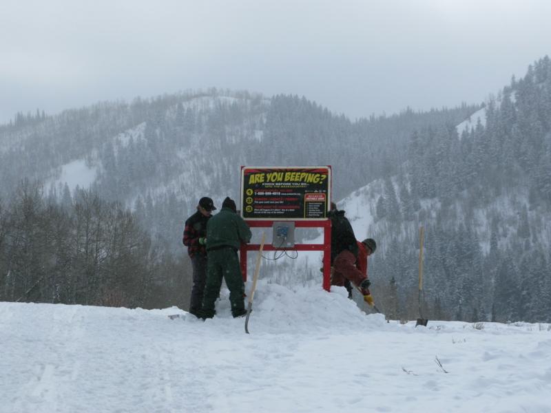
The beacon checker is closer to the trailhead this year, but still works the same. If your transmitting you see a green circle. If not... a red X appears.
![]()
You wouldn't want to run into this crew in a dark alley, but they braved the brutal cold yesterday and generously donated their valuable time to help install the BCA Beacon Park and Are You Beeping beacon checker at the Nobletts trailhead. Huge thanks to Adam, Cody, Trent, Steve, and Clint (from left) for all the hard work... that was super generous of all of you and our collective communities thank you for giving back so much. You guys rock!
 Recent Avalanches
Poor visibility and ridiculously cold temperatures have kept most riders closer to the trailheads and out of the big terrain where a long, body numbing approach is necessary... it's been unusually quiet in the western Uintas.

Persistent Weak Layer
Description
Northerly winds have been brutal along the high ridges and they're having no problem whipping all the fresh new snow into stiff wind drifts. Today you'll find these chalky looking, hollow sounding slabs along the leeward side of mid and upper elevation ridges. They're most prevalent on slopes facing the south half of the compass, but I suspect you'll find a fresh drift or two cross-loaded in upper elevation chutes and gullies as well. In either case, todays slabs will break a bit wider and deeper than you might expect and they'll be packing a body bruising punch. Best to steer clear of any fat looking, rounded pillow of snow near the ridges.
New Snow
Description
Last weeks rime crust/near surface facet combo seems to be adjusting to the recent storm and I only heard one report from Weber Canyon indicating some collapsing around this weak layer interface. Tricky thing is... this condition is most pronounced in wind sheltered, mid and lower elevation terrain facing the north half of the compass. While not widespread, it's definitely something to investigate and keep in the back of your mind as you rally in steep, lower elevation terrain today.
The forecast wouldn't be complete without a mention of avalanches breaking into old snow near the ground. While you'd really have to go out of your way to trigger a deep, dangerous slide, should your travels take you into steep, complex terrain you're gonna need to be on your A game. Carefully assess the snowpack and more importantly, think about the consequences of triggering an avalanche.
Additional Information
High pressure is building and we'll see sunny skies with temperatures rising into the mid 20's and overnight lows dip into the single digits. Northerly winds will add a bite to the air and they'll be gusting into the 40's along the high ridges, mellowing out as the day progresses.Not much change in the weather this week as high pressure remains the dominant feature of our weather pattern.
General Announcements
Remember your information can save lives. If you see anything we should know about, please participate in the creation of our own community avalanche advisory by submitting snow and avalanche conditions. You can call me directly at 801-231-2170, email [email protected], or email by clicking HERE
This is a great time of year to schedule a free avalanche awareness presentation for your group or club. You can contact me at 801-231-2170 or email [email protected]
Donate to your favorite non-profit –The Friends of the Utah Avalanche Center. The UAC depends on contributions from users like you to support our work.
The information in this advisory is from the US Forest Service which is solely responsible for its content. This advisory describes general avalanche conditions and local variations always occur.
The information in this advisory expires 24 hours after the date and time posted, but will be updated by 7:00 AM Saturday January 19th.