
Forecast for the Uintas Area Mountains

Saturday morning, January 5, 2013
Terrain to avoid- Steep, rocky, upper elevation slopes where human triggered avalanches breaking near the ground are still possible.
In general though, you'll find a MODERATE avalanche danger and human triggered avalanches are possible on steep, wind drifted slopes.
LOW avalanche danger is found in wind sheltered terrain.
 Special Announcements
Please join us on Thursday evening, 1/24 and Saturday, 1/26 for a day of learning avalanche and advanced riding skills with Craig & Trent from the Utah Avalanche Center and Dan Gardiner and the Boondockers crew. Details and sign up here
 Weather and Snow
High pressure dominates our weather pattern and it's a beautiful day to get above the inversion and enjoy the bright sunshine! Temperatures in the mountains are about 10 degrees warmer than the Salt Lake Valley. Most locations are in mid to upper teens and northerly winds are blowing 15-25 mph along the high ridges. While big open bowls and above treeline terrain got worked by strong winds early in the week, outstanding settled powder is found in wind protected terrain at mid and lower elevations.
Recent observations can be found here.
Wondering why last winter was so crazy? Click here to watch the 2011-12 Utah Winter Review... an excellent recap of last years conditions.
 Recent Avalanches

Ted was in Millcreek yesterday and found this recently triggered slide on a steep northeast aspect, where strong southwest winds overloaded weak snow near the ground. Not a huge slide, but these hard slab avalanches can fracture very deep and pile up bone crushing blocks of snow.

New Snow
Description
This years riding conditions trump anything we saw last winter and lots of riders are getting into steep terrain without incident. Much of the terrain out there offers green light conditions, but our problem child- weak, sugary snow- still persists in steep, rocky terrain. Problem is... most of the snow feels strong and bomber, allowing us to get well out onto the slope before triggering a slide. The sky isn't falling, but if your travels take you into complex terrain today stop for a moment and carefully assess the snowpack and think about the consequences of triggering an avalanche. If you're not feelin' it, simply head to lower angle terrain where you can still have a blast carving in deep snow and not have to worry about avalanches.
Persistent Weak Layer
Description
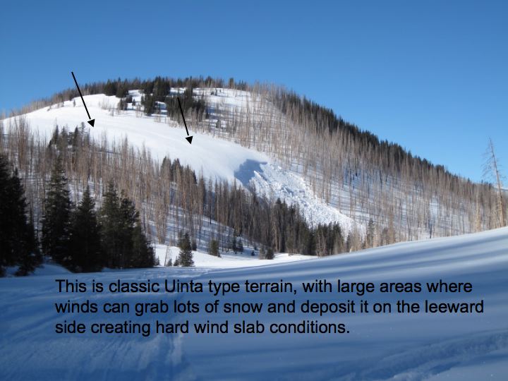
Both old and fresh wind drifts are found on steep leeward terrain facing the north half of the compass. Fat looking, rounded pillows of snow, especially those sound hollow like a drum should be avoided.
Additional Information
High pressure will give us bright sunshine through the weekend, before a weak storm slides through the region late Monday. Today you can expect high temperatures in the upper 20's with overnight lows in the mid teens. Winds shift to the southwest and blow 15-25 mph along the high ridges. Light snow is expected late Monday night with minimal accumulations. A stronger system is on tap for Thursday.
General Announcements
Remember your information can save lives. If you see anything we should know about, please participate in the creation of our own community avalanche advisory by submitting snow and avalanche conditions. You can call me directly at 801-231-2170, email [email protected], or email by clicking HERE
This is a great time of year to schedule a free avalanche awareness presentation for your group or club. You can contact me at 801-231-2170 or email [email protected]
Donate to your favorite non-profit –The Friends of the Utah Avalanche Center. The UAC depends on contributions from users like you to support our work.
The information in this advisory is from the US Forest Service which is solely responsible for its content. This advisory describes general avalanche conditions and local variations always occur.
The information in this advisory expires 24 hours after the date and time posted, but will be updated by 7:00 AM Sunday January 6th.