


Forecast for the Salt Lake Area Mountains

Sunday morning, December 30, 2012
The avalanche danger is MODERATE on steep mid and upper elevation west through north through easterly facing slopes for triggering a slide on a faceted weak layer in shallower snowpack areas. Avoid any wind drifts on steep slopes
On many slopes, the avalanche danger is generally LOW. Use normal caution – travel on steep slopes one at a time, carry a beacon, shovel and probe, and know how to use them.
 Special Announcements
Thanks so much to all those who have donate to the UAC this year! Most of our funding comes from donations and events and your support keeps the forecasts and education going. If you have not yet made a 2012 contribution, you have a few more days...
There is still space available for the Snowbird Freeride Avalanche Summit, an avalanche skills class aimed at Big Mtn Freeriders, aimed at addressing safety issues related to steep lines, remote locations, and filming. Jan 6-8 2012. Details at http://utahavalanchecenter.org/2013-snowbird-freeride-avalanche-summit.
 Weather and Snow
Skies are mostly cloudy this morning, and temperatures are once again in the teens at the mid elevations and single digits along the high ridges. While the southerly winds are averaging 15 to 20 mph in the Ogden area mountains and at a few other favored ridge line locations, most mountain stations have speeds of less than 15 mph.
Some of the steeper sunny slopes will be crusted this morning, but in general, Utah’s Greatest Snow on Earth is rather widespread these days, and riding, snowshoeing and snowmobiling conditions are excellent.
 Recent Avalanches
The only reports of backcountry avalanches were two smaller soft slabs triggered in upper Big Cottonwood, possibly from intentional slope cuts, and a few sluffs. An equally important piece of information is that explosive testing in American Fork and Cascade Ridge had no results.
The Avalanche List HERE, including an update on the Gobbler’s slide by Drew.
New Snow
Description
The shallow snowpack areas have the most pronounced mid-pack weakness of crusts and facets and weaker facets near the ground. There are still isolated places where a person could trigger a 1 to 3 foot deep slide on one of these weak layers, including rocky areas with a shallow snowpack or slopes that have slid earlier this winter. These slides could break out above you or be triggered from a distance.
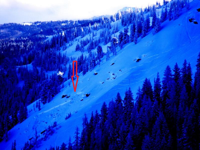
Richard Willis photo of Friday, Dec 28 Square Top slide.
Persistent Weak Layer
Description
Shallow drifts of windblown snow may exist along the high ridgelines from the overnight southerly winds. They will be most widespread on the northerly facing slopes, and while easily triggered by a person, they should be predictable in location and easy to avoid.
Additional Information
A splitting weather pattern has placed Utah on the east side of a building ridge. Today, skies will be mostly cloudy, with the peaks occasionally obscured, and even a few snow flurries are possible. Temperatures will remain cool, with highs near 20 at 8,000’ and near 10 at 10,000’. The southerly winds will continue to be very light, averaging less than 15 mph and become almost calm by this afternoon. In the long term, high pressure will dominate, with dry and cold conditions
General Announcements
Go to http://www.backcountry.com/utah-avalanche-center to get tickets from our partners at Beaver Mountain, Canyons, Sundance, and Wolf Mountain. All proceeds benefit the Utah Avalanche Center.
If you trigger an avalanche in the backcountry - especially if you are adjacent to a ski area – please call the following teams to alert them to the slide and whether anyone is missing or not. Rescue teams can be exposed to significant hazard when responding to avalanches, and do not want to do so when unneeded. Thanks.
Salt Lake and Park City – Alta Central (801-742-2033), Canyons Resort Dispatch (435-615-3322)
Ogden – Snowbasin Patrol Dispatch (801-620-1017)
Powder Mountain Ski Patrol Dispatch (801-745-3773 ex 123)
Provo – Sundance Patrol Dispatch (801-223-4150)
Dawn Patrol Forecast Hotline, updated by 05:30: 888-999-4019 option 8.
Twitter Updates for your mobile phone - DETAILS
Daily observations are frequently posted by 10 pm each evening.
Subscribe to the daily avalanche advisory e-mail click HERE.
UDOT canyon closures UDOT at (801) 975-4838
Wasatch Powderbird Guides does daily updates about where they'll be operating on this blog http://powderbird.blogspot.com/ .
Remember your information can save lives. If you see anything we should know about, please participate in the creation of our own community avalanche advisory bysubmitting snow and avalanche conditions. You can also call us at 801-524-5304 or 800-662-4140, or email by clicking HERE
Donate to your favorite non-profit –The Friends of the Utah Avalanche Center. The UAC depends on contributions from users like you to support our work.
For a print version of this advisory click HERE.
This advisory is produced by the U.S. Forest Service, which is solely responsible for its content. It describes only general avalanche conditions and local variations always exist. Specific terrain and route finding decisions should always be based on skills learned in a field-based avalanche class.