

Forecast for the Uintas Area Mountains

Saturday morning, December 29, 2012
Terrain to avoid- Steep, rocky, upper elevation slopes. At and above treeline the avalanche danger is CONSIDERABLE and human triggered avalanches are likely on steep, upper elevation, leeward slopes.
A MODERATE avalanche danger exists in mid elevation terrain and human triggered avalanches are possible on steep wind drifted slopes.
LOW avalanche danger is found in low elevation, wind sheltered sheltered terrain.
 Special Announcements
It's never too late to give that special someone (or yourself) an avalanche class for the holidays. A couple of clicks and you are done - no standing in line or shipping. Check out the Snowmobile Avalanche and Riding Skills Workshop... an avy class designed by riders for riders. Click here for more details.
 Weather and Snow
Clouds starting moving into the region late last night, but that didn't help to moderate temperatures which are struggling to climb to near zero degrees. West-southwest winds are blowing 5-15 mph with a few gusts in the teens along the high peaks. The recent series of storms has been good to the eastern front and the Uintas have gone from zero to hero. The riding and turning conditions are about as good as they get.
Recent observations can be found here.
Wondering why last winter was so crazy? Click here to watch the 2011-12 Utah Winter Review... an excellent recap of last years conditions.
 Recent Avalanches
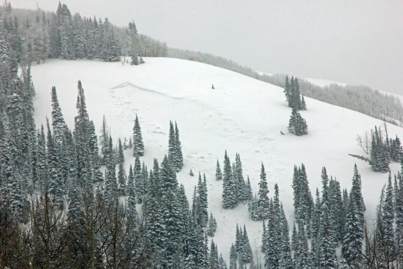
This natural avalanche was discovered on a mid elevation slope in Weber Canyon. There's a broad flat slope to the lookers right of the picture and Wednesday's strong east-southeast winds had no problem forming a huge wind drift on this steep, west-northwest aspect. The slide would definitely ruin your day. Breaking 4 ft deep x 300 ft wide near the ground to facets on an early season raincrust. In addition, collapsing in shallow snowpack regions continues.

Persistent Weak Layer
Description
The good news is... the Uintas are white and the region finally looks like winter. The bad news... collapsing in shallow areas, shooting cracks, and avalanches breaking near the ground in shallow snowpack regions has us putting the brakes on and toning down our objectives. Not every hill you climb today is gonna slide and as the snowpack gains strength it allows us to get well out onto the slope before failing. The snowpack is complex and avalanche conditions remain tricky. The most likely place to trigger a deep, scary avalanche today is going to be in steep, rocky, mid and upper elevation terrain, especially slopes facing the north half of the compass. If your travels take you into this type of terrain today carefully assess the snowpack, only put one person on the slope at a time, and above all think about the consequences of triggering an avalanche.
Persistent Weak Layer
Description
Fresh wind drifts along the leeward side of upper elevation ridges remain manageable and predictable. One wild card is- once triggered, shallow soft slabs have the potential to break into deeper buried weak layers as they crash down onto the slope below. This chain of events would quickly turn a manageable avalanche into something you didn't bargain for. Best to play it safe and avoid steep, wind drifted slopes.
Additional Information
High clouds should drift in and out of the region over the weekend, but just a passing flurry or two is expected. Southerly winds should increase throughout the day with gusts in the low 30's by late afternoon. Temperatures climb into the mid 20's before diving into to near zero overnight. A similar weather pattern is on tap for tomorrow.
General Announcements
Remember your information can save lives. If you see anything we should know about, please participate in the creation of our own community avalanche advisory by submitting snow and avalanche conditions. You can call me directly at 801-231-2170, email [email protected], or email by clicking HERE
This is a great time of year to schedule a free avalanche awareness presentation for your group or club. You can contact me at 801-231-2170 or email [email protected]
Donate to your favorite non-profit –The Friends of the Utah Avalanche Center. The UAC depends on contributions from users like you to support our work.
The information in this advisory is from the US Forest Service which is solely responsible for its content. This advisory describes general avalanche conditions and local variations always occur.
The information in this advisory expires 24 hours after the date and time posted, but will be updated by 7:00 AM Sunday December 30th.