

Forecast for the Uintas Area Mountains

Tuesday morning, December 25, 2012
Terrain to avoid- Upper elevation leeward slopes. The avalanche danger is CONSIDERABLE and human triggered avalanches are likely, particularly in steep, rocky terrain.
A MODERATE avalanche danger exists in mid elevation terrain and human triggered avalanches are possible on steep wind drifted slopes.
LOW avalanche danger is found in low elevation, wind sheltered sheltered terrain.
 Special Announcements
Bruce and I wish you all a Merry Christmas!
It's never too late to give that special someone (or yourself) an avalanche class for the holidays. A couple of clicks and you are done - no standing in line or shipping. Check out the Snowmobile Avalanche and Riding Skills Workshop... an avy class designed by riders for riders. Click here for more details.
 Weather and Snow
Wow... what a great storm for the eastern front! 6"-8" of new snow fell at the trailheads and up high you'll find just over a foot. Westerly winds gusted into the 50's yesterday afternoon just before the cold air arrived, they've mellowed out over night, switched to the northwest and are currently blowing 10-20 mph with a few gusts in the mid 20's along the high ridges. Excellent riding and turning conditions are found just about everywhere particularly in mid elevation, wind sheltered terrain.
Recent observations can be found here.
Wondering why last winter was so crazy? Click here to watch the 2011-12 Utah Winter Review... an excellent recap of last years conditions.
 Recent Avalanches
The surface snow was quite reactive late yesterday afternoon and riders reported sluffing and shallow soft slabs near the ridges.

Persistent Weak Layer
Description
Not much has changed in the overall scheme of things. While many slopes avalanched as a result of last weeks big storm, a lot of our steep terrain hangs in the balance waiting for a trigger to come along and knock the legs out from under the slab. Upper elevation, steep, rocky terrain facing the north half of the compass is the common denominator. Today's new snow will be light and fluffy and make us forget the inherently sketchy structure we're riding on. One thing is certain- once triggered, today's avalanches have the potential to break wide and deep, taking out the entire seasons snowpack, producing a very dangerous and possibly unsurvivable slide. Even if you're carving in low angle meadows make sure there's no steep slopes above or adjacent to where you're riding.
.
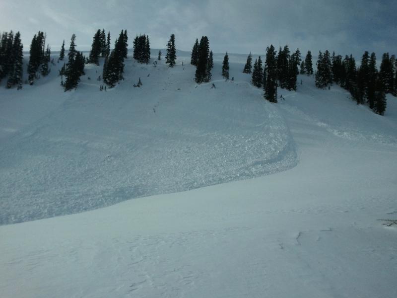
On Saturday, this slide in the Superbowl was triggered low on the slope and broke into old snow around the steep, rocky, windloaded break-over. Fortunately the rider came out unscathed and all is good.
Persistent Weak Layer
Description
Yesterdays gusty winds and new snow created sensitive wind drifts along the leeward side of upper elevation ridges. While today's soft slabs might not be quite as reactive, remember that avalanches triggered within the new snow can easily break into deeper buried weak layers as they crash down onto the slope below. This chain of events would quickly turn a manageable avalanche into something you didn't bargain for. Best to play it safe and avoid steep, wind drifted slopes.
Additional Information
Snow showers begin to taper off in the next few hours and we should see partly cloudy skies as a short-lived ridge of high pressure builds. Daytime highs reach into the low 20's with overnight lows dipping into the teens. Winds switch to the southwest late in the day and increase into the 30's by Wednesday morning, as a trough takes up residence over the region through early Friday. Snow develops late today with off and on snow through the end of the week. Storm totals should be around a foot.
General Announcements
Remember your information can save lives. If you see anything we should know about, please participate in the creation of our own community avalanche advisory by submitting snow and avalanche conditions. You can call me directly at 801-231-2170, email [email protected], or email by clicking HERE
This is a great time of year to schedule a free avalanche awareness presentation for your group or club. You can contact me at 801-231-2170 or email [email protected]
Donate to your favorite non-profit –The Friends of the Utah Avalanche Center. The UAC depends on contributions from users like you to support our work.
The information in this advisory is from the US Forest Service which is solely responsible for its content. This advisory describes general avalanche conditions and local variations always occur.
The information in this advisory expires 24 hours after the date and time posted, but will be updated by 7:00 AM Wednesday December 26th.