Forecast for the Uintas Area Mountains

Craig Gordon
Issued by Craig Gordon for
Monday, December 24, 2012

Terrain to avoid- Upper elevation leeward slopes. The avalanche danger is CONSIDERABLE and human triggered avalanches are likely, particularly in steep, rocky terrain.

A MODERATE avalanche danger exists in mid elevation terrain and human triggered avalanches are possible on steep wind drifted slopes.

LOW avalanche danger is found in low elevation, wind sheltered sheltered terrain.

Low
Moderate
Considerable
High
Extreme
Learn how to read the forecast here
Special Announcements

It's never too late to give that special someone (or yourself) an avalanche class for the holidays. A couple of clicks and you are done - no standing in line or shipping. Check out the Snowmobile Avalanche and Riding Skills Workshop... an avy class designed by riders for riders. Click here for more details.

Weather and Snow

Clouds marched into the area overnight as the first system in a one-two punch spilled into the region. Looks like the North Slope has done pretty well so far with 3"-6" of new snow falling from Trial Lake to Chalk Creek. The south half of the range picked up just an inch. West and southwest winds are blowing 10-15 mph along the ridges, gusting into the low 30's along the high peaks. Excellent riding and turning conditions are found in mid elevation, wind sheltered terrain.

Recent observations can be found here.

Wondering why last winter was so crazy? Click here to watch the 2011-12 Utah Winter Review... an excellent recap of last years conditions.

Recent Avalanches

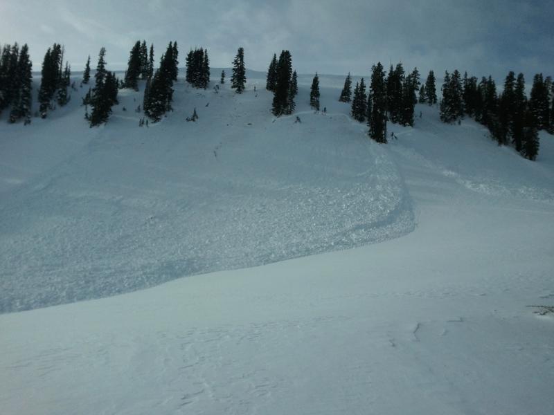
Booming collapses, remotely triggered slides breaking hundreds of feet wide and taking out the entire seasons snowpack.... it's been crazy on the eastern front the past few days!

Many thanks to Ted Scroggin, Kam, JG, Deven, Matt and Devin, and the Park City Powdercats for all the great observations and for sharing critical information that can help save other riders lives.

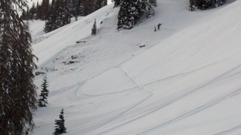
This slide in Mill Hollow was triggered mid slope in terrain we normally go ride when avalanche danger is sketchy.

Ad
Avalanche Problem #1
Persistent Weak Layer
Type
Location
Likelihood
Size
Description

Last weeks storm overloaded our midpack weaknesses and the region has seen its fair share of both natural and human triggered avalanches. Problem is... many slopes hang in the balance waiting for a trigger to come along and knock the legs out from under the slab. Upper elevation, steep, rocky terrain facing the north half of the compass is the common denominator. Today's new snow will be light and fluffy and make us forget the inherently sketchy structure we're riding on. One thing is certain- once triggered, today's avalanches have the potential to break wide and deep, taking out the entire seasons snowpack, producing a very dangerous and possibly unsurvivable slide. Even if you're carving in low angle meadows make sure there's no steep slopes above or adjacent to where you're riding.

.

This recent slide in the Superbowl was triggered low on the slope and broke into old snow around the steep, rocky, windloaded break-over. Fortunately the rider came out unscathed and all is good.

Avalanche Problem #2
Persistent Weak Layer
Type
Location
Likelihood
Size
Description

Periods of heavy snow and gusty winds this afternoon will conspire to create wind drifts sensitive to the weight of a rider. Today you'll want to avoid steep leeward slopes, especially those with recent deposits of wind drifted snow. Avalanches triggered within the new snow can easily break deeper and wider than you might expect.

Additional Information

Snow this morning, becoming heavier this afternoon as a second wave of weather slides into the region. This looks like a good shot of snow for the Eastern Front and a foot by Christmas morning is a good bet. West and southwest winds gust into the 30's, decreasing midday and switching to the northwest. Temperatures steadily decrease throughout the day, crashing to zero overnight. A sunny day is on tap for Christmas with another storm reaching the area on Wednesday.

General Announcements

Remember your information can save lives. If you see anything we should know about, please participate in the creation of our own community avalanche advisory by submitting snow and avalanche conditions. You can call me directly at 801-231-2170, email [email protected], or email by clicking HERE

This is a great time of year to schedule a free avalanche awareness presentation for your group or club. You can contact me at 801-231-2170 or email [email protected]

Donate to your favorite non-profit –The Friends of the Utah Avalanche Center. The UAC depends on contributions from users like you to support our work.

The information in this advisory is from the US Forest Service which is solely responsible for its content. This advisory describes general avalanche conditions and local variations always occur.

The information in this advisory expires 24 hours after the date and time posted, but will be updated by 7:00 AM Tuesday December 25th.