

Forecast for the Uintas Area Mountains

Saturday morning, December 22, 2012
Terrain to avoid- Upper elevation leeward slopes facing the north half of the compass The avalanche danger is HIGH on steep wind loaded slopes, especially those facing East, North, Northeast and Northwest. Dangerous and possibly unsurvivable human triggered avalanches are very likely.
A CONSIDERABLE avalanche danger exists in mid elevation terrain and human triggered avalanches are probable on steep wind drifted slopes.
If you're looking for LOW avalanche danger head to low elevation, wind sheltered sheltered terrain.
Special Avalanche Bulletin
The Western Uinta mountains have a weak underlying snowpack and dangerous avalanche conditions exist. Last weeks big storm coupled with recent winds have increased the avalanche danger. Large, human triggered avalanches breaking to the ground have already occurred. Avalanches can be triggered from a distance and on relatively flat terrain. A HIGH avalanche danger exists, particularly on steep wind drifted slopes and human triggered avalanches are very likely.
 Weather and Snow
Warm air ahead of a series of storm systems has filtered into the region. With that, of course, is wind... and man winds have been cranking! Southerly winds picked up early Friday morning, blew all day in the 50's and 60's along the high ridges, and mellowed out around midnight. Currently, south-southwest winds are blowing 20-35 mph along the ridges and temperatures are in the mid to upper 20's. Much of our upper elevation terrain is worked and wind-jacked, though soft settled powder can still be found on low and mid elevation, wind sheltered, north facing slopes.
Recent observations can be found here.
Wondering why last winter was so crazy? Click here to watch the 2011-12 Utah Winter Review... an excellent recap of last years conditions.
 Recent Avalanches
Booming collapses, remotely triggered slides breaking hundreds of feet wide and taking out the entire seasons snowpack.... it's been crazy on the eastern front the past few days!
Many thanks to Ted Scroggin (click here to see his awesome observation from yesterday), Kam Kohler, JG, and the Park City Powdercats for all the great observations and for sharing critical information that can help save other riders lives.
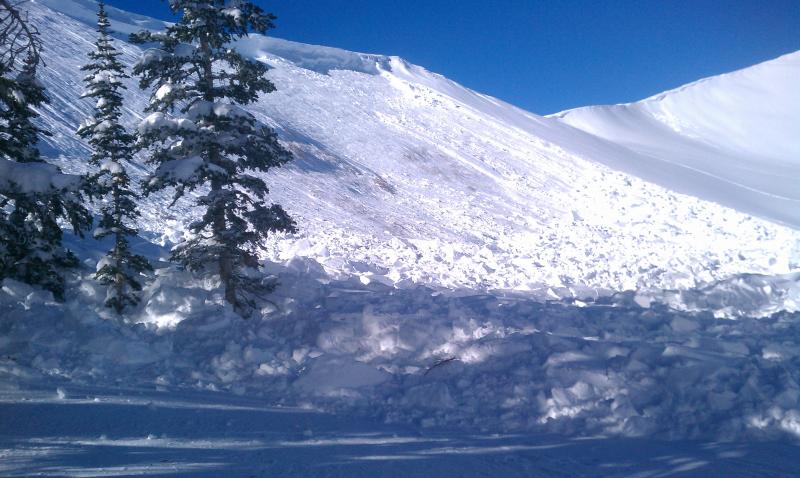
This slide in Roundy Basin was triggered from a distance with no one on the slope after several sledders had already rode through the area.

Persistent Weak Layer
Description
It's been a couple of very active days in the western Uinta's.... perhaps the Mayan Prophecy is coming true. Last weeks storm overloaded our midpack weaknesses and the region is coming unglued. Problem is... most slopes hang in the balance waiting for a trigger to come along and knock the legs out from under the slab. Adding a dangerously tricky variable to this already complicated mess is the fact that you can trigger avalanches from a distance and on relatively flat terrain. Once triggered, today's avalanches have the potential to break wide and deep, taking out the entire seasons snowpack, producing a very dangerous and possibly unsurvivable slide. Even if you're carving in low angle meadows make sure there's no steep slopes above or adjacent to where you're riding.
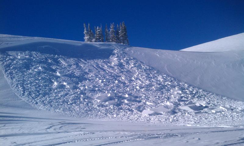
Holy cow! Another slide that broke near the ground. This slide was triggered from flat terrain!
Persistent Weak Layer
Description
Winds have helped complicate the avalanche danger and are forming yet another layer of slab to our already sketchy snowpack. Today you'll want to avoid steep slopes facing the north half of the compass, especially those with recent deposits of wind drifted snow. Avalanches triggered in the fresh wind drifts can easily break deeper and wider than you might expect.
Additional Information
Today we should see increasing clouds and wind as a weakening weather system moves across the region late tonight into Sunday morning. Southwest winds remain a nuisance, blowing 15-30 mph with gusts in the 40's and 50's along the high peaks. High temperatures don't vary much from where we're at this morning and overnight lows dip into the mid teens. By morning we should see 1"-3" of new snow. A stronger system moves across the area Sunday night into Tuesday morning. This could be a good snow producer for the Uintas with a foot or so a good bet. More details to come for tomorrows advisory.
General Announcements
Remember your information can save lives. If you see anything we should know about, please participate in the creation of our own community avalanche advisory by submitting snow and avalanche conditions. You can call me directly at 801-231-2170, email [email protected], or email by clicking HERE
This is a great time of year to schedule a free avalanche awareness presentation for your group or club. You can contact me at 801-231-2170 or email [email protected]
Donate to your favorite non-profit –The Friends of the Utah Avalanche Center. The UAC depends on contributions from users like you to support our work.
The information in this advisory is from the US Forest Service which is solely responsible for its content. This advisory describes general avalanche conditions and local variations always occur.
The information in this advisory expires 24 hours after the date and time posted, but will be updated by 7:00 AM Saturday December 23rd.