

Forecast for the Salt Lake Area Mountains

Friday morning, December 21, 2012
CONSIDERABLE Avalanche Danger exists in shallow snow pack areas including the Park City ridgeline and Mill Creek Canyon, on all steep, mid and upper elevation northerly through easterly facing slopes. Slides can be triggered from a distance, and break into deeper weak layers, resulting in large, deadly slides. Deeper snowpack areas are safer but new windloading is a distinct concern today in these areas also.
 Weather and Snow
Temperatures are up and so are the winds. We have 25 to 30 degrees along the ridges and southwest winds a little stronger than yesterday during the day with moderate speed gusts along the mid elevations and gusts into the 50s and 60s along the more exposed terrain. Upper elevation snow surface conditions have deteriorated but mid elevations remain excellent.
 Recent Avalanches
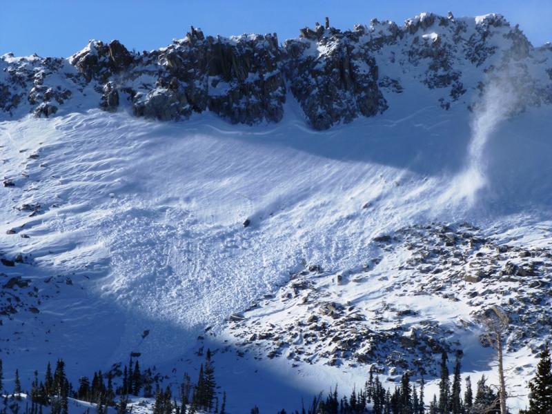
Two avalanches from Thursday highlight both our avalanche concerns for today. First, the wind drifted enough snow yesterday to create a natural new snow only soft slab avalanche in Maybird at near 10,000 feet on a northeast facing slope. DETAILS
The second avalanche was reported from UDOT in Provo where a new wind load overloaded deeper buried weak layers. DETAILS
Despite some predictions of doomsday, my outlook is more hopeful. I woke up at 3am this morning just like usual. Also, I feel we have slid into a fairly average winter. It is not uncommon for us to be dealing with some buried faceted snow at this time of the year. It is also not uncommon for the deeper areas to stabilize first. A look at some Snotel charts in our central region (blue=average, green=this season, red=last season) paint quite and average picture, which is a good sign for our snowpack.


The weather outlook is favorable for continued strengthening. More snow is always better in the long run. That being said, you better not let your guard down. Deciphering between areas with a strong snowpack and areas with a weak structure is difficult especially for the less experienced backcountry traveler. There are reasons why Cardiac Ridge was “wall to walled” and the Monitors are not. Be honest with yourself to make sure you understand, really understand, the underlying snow structure before getting onto any big lines. There's still plenty of danger out there right now.
Persistent Weak Layer
Description
Fresh wind drifts that may release under the weight of a person or a sled is your first order of business today. Be leery of those fresh pillows or any slope that sits below a plume coming off a ridge. Primary suspect aspects are north through east but watch for loading on all aspects as the wind can stir the snow up quite randomly.
New Snow
Description
The more dangerous but not as likely to occur problem is buried weak snow. Thinner overall snowpack depths on north through east aspects are the most likely spots to see this and the recent wind loading only increases the danger.
Additional Information
It's going to be a bit blustery today with continued southwest winds in the moderate range along the mid elevations and stronger gusts up high. Temperatures will remain fairly mild with highs in the mid to upper 20s along the ridges. We'll see some increasing clouds and continued southerly winds on Saturday ahead of a mild disturbance and then a better looking storm for Sunday night through Monday with hopefully another foot of new snow.
General Announcements
Go to http://www.backcountry.com/utah-avalanche-center to get tickets from our partners at Ala, Beaver Mountain, Brighton, Canyons, Deer Valley, Park City, Powder Mountain, Snowbasin, Snowbird, Solitude, Sundance, and Wolf Mountain. All proceeds benefit the Utah Avalanche Center.
If you trigger an avalanche in the backcountry - especially if you are adjacent to a ski area – please call the following teams to alert them to the slide and whether anyone is missing or not. Rescue teams can be exposed to significant hazard when responding to avalanches, and do not want to do so when unneeded. Thanks.
Salt Lake and Park City – Alta Central (801-742-2033), Canyons Resort Dispatch (435-615-3322)
Ogden – Snowbasin Patrol Dispatch (801-620-1017)
Powder Mountain Ski Patrol Dispatch (801-745-3773 ex 123)
Provo – Sundance Patrol Dispatch (801-223-4150)
Dawn Patrol Forecast Hotline, updated by 05:30: 888-999-4019 option 8.
Twitter Updates for your mobile phone - DETAILS
Daily observations are frequently posted by 10 pm each evening.
Subscribe to the daily avalanche advisory e-mail click HERE.
UDOT canyon closures UDOT at (801) 975-4838
Wasatch Powderbird Guides does daily updates about where they'll be operating on this blog http://powderbird.blogspot.com/ .
Remember your information can save lives. If you see anything we should know about, please participate in the creation of our own community avalanche advisory bysubmitting snow and avalanche conditions. You can also call us at 801-524-5304 or 800-662-4140, or email by clicking HERE
Donate to your favorite non-profit –The Friends of the Utah Avalanche Center. The UAC depends on contributions from users like you to support our work.
For a print version of this advisory click HERE.
This advisory is produced by the U.S. Forest Service, which is solely responsible for its content. It describes only general avalanche conditions and local variations always exist. Specific terrain and route finding decisions should always be based on skills learned in a field-based avalanche class.