


Forecast for the Salt Lake Area Mountains

Thursday morning, December 20, 2012
CONSIDERABLE Avalanche Danger exists in shallow snow pack areas (Rose): including the Park City ridgeline and Mill Creek Canyon, on all steep, mid and upper elevation northerly through easterly facing slopes. Slides can be triggered from a distance, and break into deeper weak layers, resulting in large, deadly slides. Mid Canyon terrain in Big Cottonwood is a transition zone to the deeper snowpack terrain.
MODERATE Avalanche Danger in the deeper snowpack terrain: including upper Big and Little Cottonwood, where the avalanche danger is a notch lower. There are still steep, shallow, rocky slopes where a person can trigger a deep slide, including slopes that have already slid this year, they are just fewer and more localized.
Confusing? Go to: Low angle terrain, less steep than about 33 degrees, out from under steep slopes, where there is just as much wonderful powder.
 Special Announcements
Canyons Ski Patrol will be doing avalanche control work in the McDonald Draw area today, and to please avoid that area.
The first of a series of Thursday night presentations at Snowbird will be held tonight, with Tyson Bradley of Utah Mountain Adventures presenting a 2012 Haute Route trip. Details on these events and more at http://utahavalanchecenter.
Discount lift tickets are in! Go to http://www.backcountry.com/utah-avalanche-center to get tickets from our partners at Beaver Mountain, Brighton, Canyons, Deer Valley, Park City, Powder Mountain, Snowbasin, Snowbird, Solitude, Sundance, and Wolf Mountain. All proceeds benefit the Utah Avalanche Center. A big thanks to the Utah mountain resorts - we couldn't do it without your partnership.
 Weather and Snow
Under clear skies, it’s a beautiful morning, with light southwesterly winds, averaging less than 15 mph, and temperatures that have warmed into the single digits to mid-teens. So much powder, so little time…travel on all aspects, including slopes facing the south ½ of the compass and the lower angle slopes, is great in abundant settled powder.
 Recent Avalanches
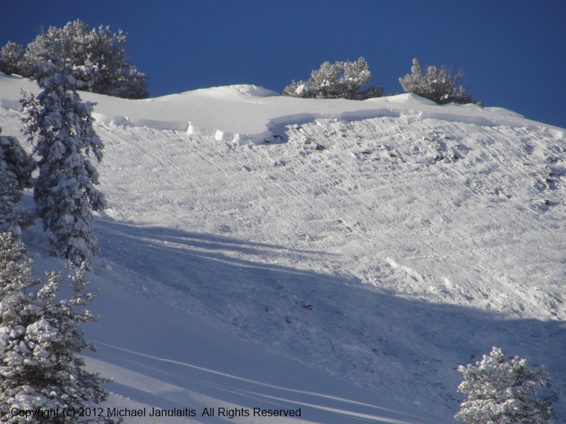
A very close call in Dutch Draw, an east facing slope along the Park City ridge line, when the third person in the party triggered a large hard slab avalanche remotely. T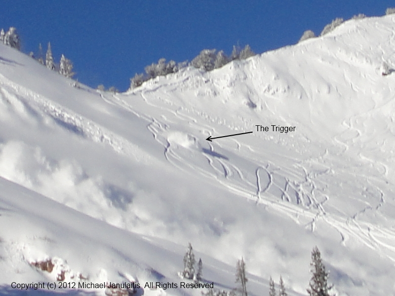 heir partners in the run out zone were dusted, but not buried. A second large slide was triggered by explosives. A picture is worth 1,000 words check - check out more amazing photos. http://utahavalanchecenter.org/avalanches/avalanche-dutch-draw
There were no other reports of backcountry avalanches. The resorts in Big Cottonwood and on the Park City side were able to trigger 2 slides breaking into old snow with explosives, up to 3’ deep, on easterly facing slopes. Wind slabs to 2 feet deep also released with explosives.
New Snow
Description
There is a sharp contrast in stability between shallow snowpack and deeper snowpack areas. The weakest facet/crust sandwiches are on northerly through easterly facing slopes, from as low as 8,000’ all the way to the ridgelines. The weak snow is most widespread in shallow snowpack areas – the Park City ridgeline and Mill Creek Canyon. Large, dangerous slides can still be triggered by a person today, or by a smaller new snow slide stepping down. Faceted weak layers mean you can release avalanches from a distance, or they can be stubborn, and break out above you or on the 2nd or 3rd person.
Persistent Weak Layer
Description
Heating, wind slabs, and sluffs…
- Rapid warming today, with high temperatures 20 degrees above yesterday’s at most elevations, may make the snow more sensitive to triggers, especially on steep, sunny slopes facing southeast through south through westerly.
- Wind speeds, especially in the Ogden area mountains and across the highest ridgelines, will increase just enough to blow and drift snow – avoid new drifts on steep slopes.
- Sluffs, after another cold, clear night, may be just large enough today on steep, wind sheltered slopes, to knock you off your feet.
Additional Information
High pressure is bringing much warmer temperatures, with highs near 20 at 10,000’. The southwesterly winds will be in the 5 to 15 mph range, with gusts to 25. A few of the highest peaks, including the high ridgelines in the Ogden area mountains, will have average winds speeds 20 to 30 mph, with gusts to 40 mph. An increasingly warm, southwest flow Friday and Saturday will be followed by two small storms, Sunday and Monday, with Monday’s the best chance for a reasonable shot of snow.
General Announcements
Go to http://www.backcountry.com/utah-avalanche-center to get tickets from our partners at Ala, Beaver Mountain, Brighton, Canyons, Deer Valley, Park City, Powder Mountain, Snowbasin, Snowbird, Solitude, Sundance, and Wolf Mountain. All proceeds benefit the Utah Avalanche Center.
If you trigger an avalanche in the backcountry - especially if you are adjacent to a ski area – please call the following teams to alert them to the slide and whether anyone is missing or not. Rescue teams can be exposed to significant hazard when responding to avalanches, and do not want to do so when unneeded. Thanks.
Salt Lake and Park City – Alta Central (801-742-2033), Canyons Resort Dispatch (435-615-3322)
Ogden – Snowbasin Patrol Dispatch (801-620-1017)
Powder Mountain Ski Patrol Dispatch (801-745-3773 ex 123)
Provo – Sundance Patrol Dispatch (801-223-4150)
Dawn Patrol Forecast Hotline, updated by 05:30: 888-999-4019 option 8.
Twitter Updates for your mobile phone - DETAILS
Daily observations are frequently posted by 10 pm each evening.
Subscribe to the daily avalanche advisory e-mail click HERE.
UDOT canyon closures UDOT at (801) 975-4838
Wasatch Powderbird Guides does daily updates about where they'll be operating on this blog http://powderbird.blogspot.com/ .
Remember your information can save lives. If you see anything we should know about, please participate in the creation of our own community avalanche advisory bysubmitting snow and avalanche conditions. You can also call us at 801-524-5304 or 800-662-4140, or email by clicking HERE
Donate to your favorite non-profit –The Friends of the Utah Avalanche Center. The UAC depends on contributions from users like you to support our work.
For a print version of this advisory click HERE.
This advisory is produced by the U.S. Forest Service, which is solely responsible for its content. It describes only general avalanche conditions and local variations always exist. Specific terrain and route finding decisions should always be based on skills learned in a field-based avalanche class.