

Forecast for the Uintas Area Mountains

Monday morning, December 17, 2012
Terrain to avoid- mid and upper elevation leeward slopes facing the half of the compass The avalanche danger is CONSIDERABLE on steep wind loaded slopes and human triggered avalanches are probable.
LOW avalanche danger exists on wind sheltered slopes.
Avalanche Watch
 Weather and Snow
Skies are mostly cloudy and light snow continues to fall this morning with another 2" overnight. Storm totals are just over a foot. Temperatures have risen 5 degrees since yesterday and are currently in the low 20's. West and southwest winds are blowing 25-30 mph along the ridges. Very good riding conditions can be found in wind sheltered terrain.
Recent observations can be found here.
Wondering why last winter was so crazy? Click here to watch the 2011-12 Utah Winter Review... an excellent recap of last years conditions.
 Recent Avalanches
Sluffing on steep slopes and shallow soft slabs continue to be the theme throughout the range.
In addition, plenty of loud booming collapses are being reported, particularly in regions where the snowpack remains thin and shallow.
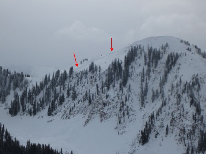
Yikes... Ted found this large natural in upper Weber Canyon, just west of Moffit Peak. Breaking to the ground on weak, shallow snow, looks like it released from the strong winds on 12-12-12.

Persistent Weak Layer
Description
Fresh wind drifts are the most obvious of today's avalanche problems. Easy to detect by their rounded appearance, they'll also be easy to manage this morning, breaking around or just below your skis, board, or sled. As winds increase I expect the drifting to become more widespread and slabs will break deeper and wider than you might anticipate. Once initiated, today's shallow slabs can quickly get out of hand, breaking into deeper buried weak layers as they crash down onto the slope below and they'll be packing a punch.
New Snow
Description
So far we haven't heard of any slides breaking into old snow in our neighborhood, but the structure of our snowpack remains eerily suspect. The setup is simple... strong snow overlies a layer of weak, sugary facets now buried in the mid portion of our snowpack. Unless you're willing to take a few minutes to dig into the snow and investigate, avalanche conditions may seem manageable on the surface. Unfortunately, this type of composition feels strong under our skis, board, or sled, and allows to get well out onto steep slopes before they avalanche.
We're seeing the in your face telltale signs of unstable snow coming together... booming collapses, shooting cracks, and avalanches are natures way of saying the snowpack is sketchy If you're getting onto steep, upper elevation slopes, especially those with an easterly component to their aspect, carefully assess the snowpack and think about the consequences of triggering a slide.
Click here to view our observations along with a short video explaining what we're seeing.
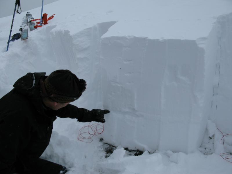
Ted points to our problem child... a layer of weak snow now buried a couple feet deep in our snowpack.
Additional Information
Today we should see periods of snow with very strong ridgetop winds developing. West and southwest winds will ramp up throughout the day and should be cranking into the 50's and 60's along the ridges by the afternoon. We should see a couple inches of snow today, then 8"-10" maybe a foot overnight, as a strong cold front slides through the region. Temperatures rise into the mid 20's before bottoming out in the single digits late tonight. Snow lingers through Tuesday and early Wednesday morning.
General Announcements
Remember your information can save lives. If you see anything we should know about, please participate in the creation of our own community avalanche advisory by submitting snow and avalanche conditions. You can call me directly at 801-231-2170, email [email protected], or email by clicking HERE
This is a great time of year to schedule a free avalanche awareness presentation for your group or club. You can contact me at 801-231-2170 or email [email protected]
Donate to your favorite non-profit –The Friends of the Utah Avalanche Center. The UAC depends on contributions from users like you to support our work.
The information in this advisory is from the US Forest Service which is solely responsible for its content. This advisory describes general avalanche conditions and local variations always occur.
The information in this advisory expires 24 hours after the date and time posted, but will be updated by 7:00 AM Tuesday December 18th.