Forecast for the Provo Area Mountains

Issued by Bruce Tremper for
Tuesday, November 13, 2012

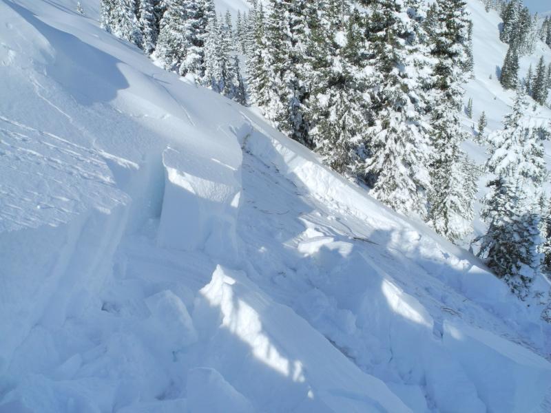
The avalanche danger remains CONSIDERABLE on northwest, north and northeasterly facing slopes above about 9,000' and steeper than about 30 degrees. This means potentially dangerous human triggered avalanches are LIKELY and you should avoid these slopes. Most of the other aspects and elevations are quite stable. We will update this forecast some time on Wednesday. We expect the danger to remain CONSIDERABLE tomorrow.

Low
Moderate
Considerable
High
Extreme
Learn how to read the forecast here
Special Announcements

Note: If the pieces of the rose are not in the proper place, just refresh your browser. We loaded a new module. We are still in the process of transferring the pages and content from our old website to the new site, so be patient. We are also tweaking the look and design so you may notice some changes. When everything is finished, it should all be pretty cool.

Weather and Snow

Wow, that was quite a storm last weekend. It seems like everybody's Facebook posts are filled with powder shots. For storm totals: 9 to 11” fell in the Provo area mountains, up to 19” in the Ogden area mountains, generally 2 feet on the Park City side with up to 3’ along the ridge line, 3 feet in Big Cottonwood and just over 4 feet in Little Cottonwood. The snow has settled considerably to about half the depths mentioned above, so trailbreaking is much easier and you are not hitting as many rocks.

Temperatures warmed considerably yesterday. The thermometer climbed above freezing in the afternoon, which put a thin sun crust on the sunny aspects but the riding conditions remain good on settled powder on the shady aspects.

Recent Avalanches

Yesterday there was much less avalanche activity than the weekend, which probably had more to do with the behavior of people rather than behavior of the snowpack. One skier remotely triggered a pocket in the Salt Lake area mountains on the headwall of Silver Fork in Big Cottonwood Canyon Check out the details in “All The Good Stuff” ). Otherwise, there was not much activity.

Ad
Avalanche Problem #1
New Snow
Type
Location
Likelihood
Size
Description

The reason we call these "Persistent Slabs," is because, well, they are persistent. Once loaded with weight, they continue to produce avalanches for several days, which make them especially tricky. For this reason, they are responsible for almost all our avalanche accidents.

Check out the VIDEO I did yesterday on the huge avalanche some skiers remotely triggered on Sunset Peak on Sunday.

Take-home point: Avoid the upper elevation, shady aspects. All the other slopes are quite stable. The avalanche danger in these areas is CONSIDERABLE, meaning that human triggered avalanches are LIKELY and they can be quite dangerous.

Reason: Even though there was only about 6 inches of snow left over from October, it rotted because of temperature gradient metamorphism into very weak, sugary crystals. The sun melted it off all the sunny aspects, so the only places where it remained before the storm was above about 9,000' on northwest, north and northeast facing slopes. When the large amounts of new snow overloaded that weak layer, it produced large avalanches.

Note: on the rose diagram, the blue color represents the places where you will MOST LIKELY find the avalanche problem, not all the places where you will find it. For a more detailed tutorial on how to read the advisory, click HERE. For a rose with the avalanche danger plotted on it, click HERE.

Additional Information

We should continue to have warm weather for the remainder of the week with various high and mid elevation clouds. Daytime highs should be around freezing with overnight lows in the mid teens. Ridge top winds should be fairly light from west and southwest.

For the extended forecast, we will have some clouds and perhaps some light snow showers from systems going by to the north of us on Thursday through the weekend and then it looks like perhaps some more significant snow by about next weekend.

General Announcements

If you trigger an avalanche in the backcountry - especially if you are adjacent to a ski area – please call the following teams to alert them to the slide and whether anyone is missing or not. Rescue teams can be exposed to significant hazard when responding to avalanches, and do not want to do so when unneeded. Thanks.

Salt Lake and Park City – Alta Central (801-742-2033)

Ogden – Snowbasin Patrol Dispatch (801-620-1017)

Provo – Sundance Patrol Dispatch (801-223-4150)

Dawn Patrol Forecast Hotline, updated by 05:30: 888-999-4019 option 8.

Twitter Updates for your mobile phone

Daily observations are frequently posted by 10 pm each evening.

Subscribe to the daily avalanche advisory e-mail click HERE.

UDOT canyon closures UDOT at (801) 975-4838

Wasatch Powderbird Guides does daily updates about where they'll be operating on this blog http://powderbird.blogspot.com/ .

Remember your information can save lives. If you see anything we should know about, please participate in the creation of our own community avalanche advisory by submitting snow and avalanche conditions. You can also call us at 801-524-5304 or 800-662-4140, or email by clicking HERE

Donate to your favorite non-profit –The Friends of the Utah Avalanche Center. The UAC depends on contributions from users like you to support our work.

We will update this forecast tomorrow. Thanks for calling.