Forecast for the Uintas Area Mountains

Craig Gordon
Issued by Craig Gordon on
Wednesday morning, April 2, 2025
Remember... it's spring and avalanche conditions can change rapidly, especially if the sun pokes out for any length of time-
In the windzone, at and above treeline, the avalanche danger is CONSIDERABLE today. Human triggered avalanches breaking into fresh wind drifted snow are LIKELY, especially on steep, leeward slopes. Not as touchy as yesterday, but today's slabs are big enough to boss you around.
Out of the wind zone, expect a more straightforward, MODERATE avalanche hazard. While more “manageable” in size, human triggered avalanches are still POSSIBLE and should be given a little respect as they might break wider, and run farther than we expect due to the slick bed surface they rest on.
At low elevations, where the winter snowpack has mostly, or completely evaporated, the avalanche danger is generally LOW.
Low
Moderate
Considerable
High
Extreme
Learn how to read the forecast here
Special Announcements
The final report for the Hoyt Peak avalanche accident on March 7th has been published and is available, here.
Motorized Users—Please consider taking this 5-minute survey to help researchers better understand avalanche education participation and safety preparedness. Responses are anonymous and confidential.
Weather and Snow
Nowcast: Wow... a great shot of snow and water for the eastern front! Since late Monday afternoon, most areas piled up a solid 10" of medium density snow with 1.1" ish H2O. But wait... there's more! A North Slope centric, mid morning April fools impulse delivered a low density, chin tickling topper, pushing storm totals to 15" snow with 1.6" H2O. West and northwest winds are well-behaved this morning, blowing just 5-15 mph even near the high peaks. With high clouds overhead, a few scattered snow flurries linger and the mercury starts its day in the single digits.
Forecast: Look for mostly cloudy skies with scattered snow showers drifting by the region. West and northwest winds blow in the teens, whilst high temperatures climb into the mid and upper 20's. Under partly cloudy skies, overnight lows dip into the teens.
Futurecast: Unsettled weather continues across the region to wrap up the work week. A warming and drying trend settles in for the weekend into early next week.
Travel and Riding Conditions: Redeem that coupon for your free, over-the-hood, over-the-head powder day... riding and turning conditions are all-time, particularly on mid elevation, wind sheltered slopes.
Recent Avalanches
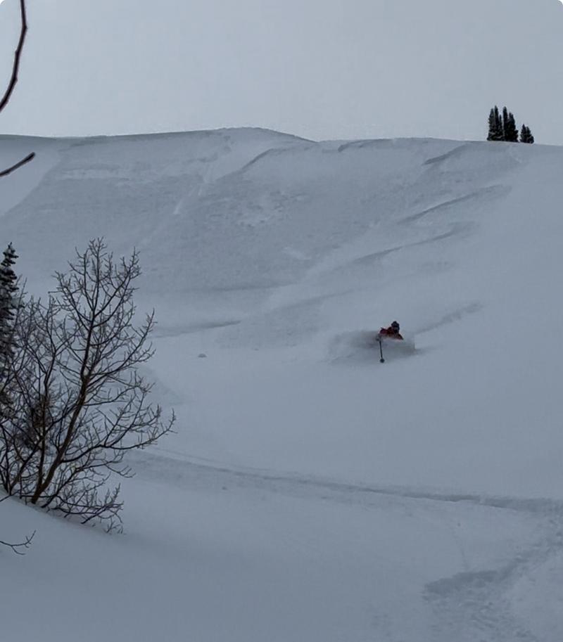
Avy-savvy, local snow-pro extraordinaire, Trevor Katz, caught this great image of yesterday's flavor of the day avalanche problem... human triggered, shallow, and very sensitive drifts, on steep, leeward slopes.
Check out all trip reports, avy obs, and general intel from around the state here.
Ad
Avalanche Problem #1
Wind Drifted Snow
Type
Location
Likelihood
Size
Description
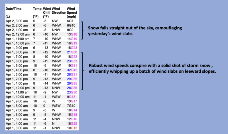
Above, a 24 hour data dump from Windy Peak illustrating the strength, duration, and variability during our recent storm.
I suspect yesterday's drifts settled out nicely overnight, gained a little strength, and won't be nearly as touchy today. But, here's where it gets tricky... recent wind slabs are camouflaged with a few inches of overnight snow, making them hard to detect. In addition, all of our storm snow rests on top of a slick crust that formed during last week's heat spell, and that means any avalanche triggered will break a bit wider and a bit run further than we might expect.
Lose the wind and you lose the problem. Yeah... simply avoid steep leeward slopes that appear fat, rounded, and pillowy in nature. I’m taking that intel and heading to mid elevation, wind sheltered terrain where I know I can avoid the problem and score an epic day of riding to boot!

Monday's afternnon wind busy at work in upper elevation leeward terrain.
Avalanche Problem #2
New Snow
Type
Location
Likelihood
Size
Description
The Uinta's stacked up a respectable amount of storm snow in a short timeframe and it's deep out there! While most new snow instabilities settle out rather quickly, I suspect our recent round of storm snow will remain reactive to our additional weight, especially on sustained steep slopes. This is an easy to manage avalanche problem by toning our slope angles down a degree or two.
Additional Information
General Announcements
We are always looking for snow and avalanche observations or just general riding conditions. In the meantime reach out to us with questions, concerns, or if you see anything in your travels! Contact us directly through the info below:
This forecast is from the U.S.D.A. Forest Service, which is solely responsible for its content. This forecast describes general avalanche conditions and local variations always occur. This forecast was issued on Wednesday, April 2nd at 03:30 AM and expires 24 hours after it was issued.