Join us at our 2nd Annual Blizzard Ball

Forecast for the Uintas Area Mountains

Craig Gordon
Issued by Craig Gordon on
Tuesday morning, April 2, 2024
Get after it before the sun beats you to the punch-
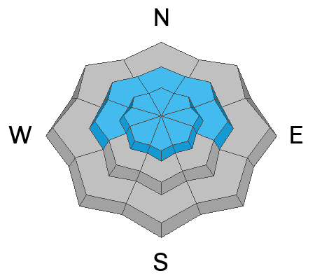
Not widespread and pockety in distribution, size, and scope you'll find MODERATE avalanche danger at above above treeline today. Human triggered avalanches are POSSIBLE around the dial, especially on steep, wind drifted, leeward slopes in high alpine terrain.

Lose the wind and you lose the problem. LOW avalanche danger is found on wind sheltered slopes and most terrain facing the south half of the compass where human triggered avalanches are UNLIKELY.

Low
Moderate
Considerable
High
Extreme
Learn how to read the forecast here
Special Announcements
Huuuge thanks to everyone who helped make our spring fundraising campaign a remarkable success! Without you, there is no us, and we couldn't pull this off without your very generous support :)
Weather and Snow
Nowcast- The weekend storm exits the stadium and in its wake, the Uintas offer clear skies with temperatures hovering in the teens and low 20's. Wind blew in the 20's and 30's from the north and northeast to kick off the workweek, but began tapering off at the turn of the new day. At o'dark thirty this morning, winds barely spin the propellers of ridgetop anemometers. Recent storms helped with a nice, region-wide reset and you'll find cold, creamy snow on upper elevation wind sheltered slopes. Lower elevation terrain and most slopes facing the south half of the compass got kissed by the sun yesterday and will have a thin heat crust this morning.
Forecast- It'll be a stunning day with clear skies, light winds from the north and northwest, and temperatures climbing into the mid 30's.
Futurecast- Wednesday offers similar weather with temperatures climbing a few more degrees. Thursday is warm and windy with another storm setting sights set to round out the workweek.
The Uintas are fat and white. In fact, it's been snowing off and on for the past 8 days and we've stacked up nearly three feet of snow with over 4" of water at the Trial Lake SNOTEL... Mr. Gile seconds that emotion from the white room in the image above.
Recent Avalanches
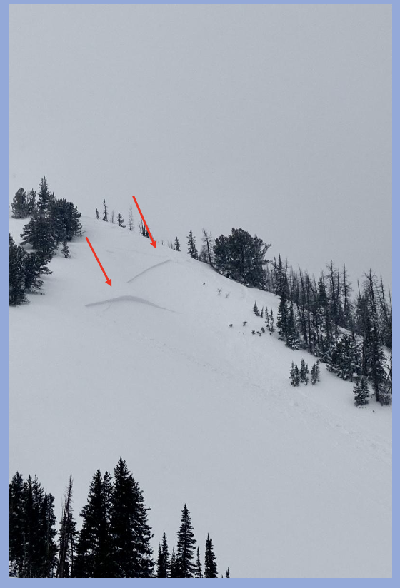
Breaking 12"-18" deep, the only slides reported yesterday were on steep, wind drifted, leeward slopes in the wind zone.

For all Uinta observations and archived avalanche activity click HERE.
Ad
Avalanche Problem #1
Wind Drifted Snow
Type
Location
Likelihood
Size
Description
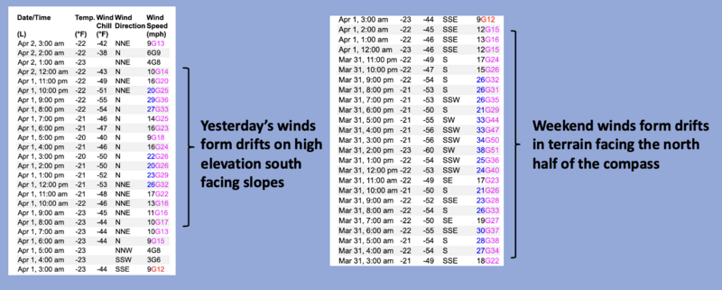
Above is a 48 hour wind run from Lofty Lake Peak (11,186'). Please disregard temps, the sensor is jacked, and focus on wind speed, direction, and duration.
Winds have been all over the map for the past 48 hours, and with no shortage of snow available to blow around, drifts formed around the compass and in unusual locations. I think most of our drifting issues settled out and won't be nearly as reactive, but if my objectives take me into big terrain, I'd step out cautiously, but with intent. Gather as much information as you can in your travels. Tweak small test slopes like road cuts and see how they're reacting before center-punching a committing line. Lose the wind... you lose the problem.

Additional Information
The Uinta weather station network was upgraded this summer and all that real-time info is found HERE. Simply click on "western Uinta" tab and then "weather stations" tab.

We are always looking for snow and avalanche observations or just general riding conditions. So... if you see something, say something. You can reach me directly at [email protected] or 801-231-2170.
Also, if you're looking for more avy education opportunities for yourself, your crew, or your club please don't hesitate to reach out to me and we'll find a presentation, class, or clinic for ya!
General Announcements

Issued at 0330 on Tuesday, April 2nd this forecast will be updated by 0700 Wednesday, April 3rd, 2024.
This forecast is from the U.S.D.A. Forest Service, which is solely responsible for its content. This forecast describes general avalanche conditions and local variations always occur.