Donate to Our Spring Campaign or Bid on our Spring Auction to Support Forecasting

Forecast for the Uintas Area Mountains

Craig Gordon
Issued by Craig Gordon on
Thursday morning, March 27, 2025
Strong winds and increasing cloud cover may help temper today's wet avalanche activity, but we've had 48 hours of marginal refreeze, and it's making the snowpack irritable-
I suspect we hold steady with MODERATE avalanche danger from tip to tail and around the compass. Human triggered, damp snow avalanches are POSSIBLE on steep, sun exposed slopes, especially during the heat of day.
Additionally, today's heat may activate persistent weak layers on the north half of the compass at mid and upper-elevations, where once triggered, avalanches will break to sugary weak layers deeper in the pack.
Remember... if you're feeling like an ant under a magnifying glass, so is the snowpack and it's time to get off of an out from under steep sun-baked slopes. (Of course, no ants were harmed in the use of this simile :)
Low
Moderate
Considerable
High
Extreme
Learn how to read the forecast here
Special Announcements
Big thanks to everyone who came to last night's State of the Snowpack prezo at PC Brewing. It was great to see old friends and make some new ones along the way!
  • The final report for the Hoyt Peak avalanche accident on March 7th has been published and is available, here.
  • Our Spring Campaign is in full swing, and there are two great ways to support forecasting, awareness, and education across Utah: Donate to our Spring Campaign or bid on items in our Spring Auction. Every dollar helps keep the backcountry community on top. Thank you for your support!
Weather and Snow
Nowcast- The good news is... clear skies allow the snowpack to lose heat overnight, but temperatures registering in the mid and upper 30's deliver a superficial, snow surface refreeze. After a brief respite late yesterday, southerly winds are back at work this morning, blowing 30-40 mph along the high peaks.
Forecast- The warm before a weak little storm. Look for increasing clouds and southwest winds ramping into the 50's by late in the day, while high temperatures soar into the mid 50's. A weak cold front drifts into the Uinta zone overnight, delivering a trace of snow with temperatures cooling into the low 30's.
Futurecast- A deeper trough and strong cold front pushes into northern Utah Saturday morning and brings a nice shot of snow late in the day. I'm cautiously optimistic this storm delivers a foot of snow with an inch of water for Sunday's morning service. A break in the action rounds out the weekend, but a return to active weather is on tap for next week.
Travel & Riding Conditions- Yesterday's corn harvest began right around 10:00 and wrapped up shortly after suppertime. Last night's marginal refreeze limits the reliability of our go-anywhere snowpack and offers a tight morning window for our harvesting endeavors.
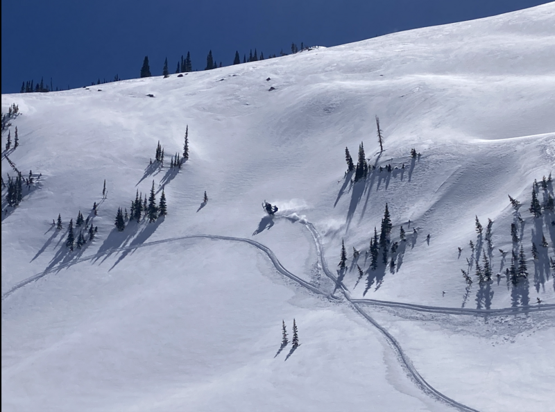
Really... a wheelie? Alden G tagging some fresh snow in the alpine on Sunday. While there's still a few patches of shallow pow, cold snow is an elusive commodity.
Recent Avalanches
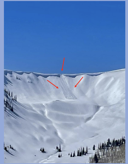
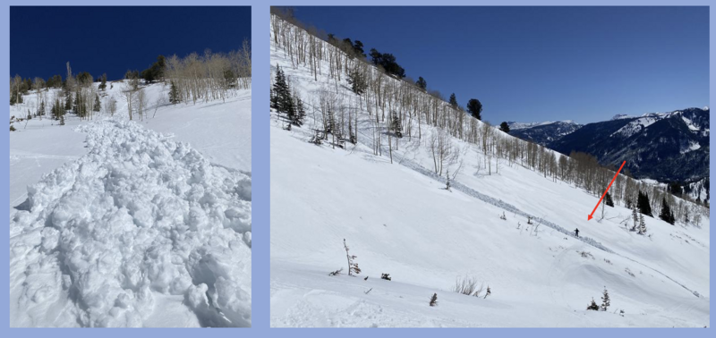
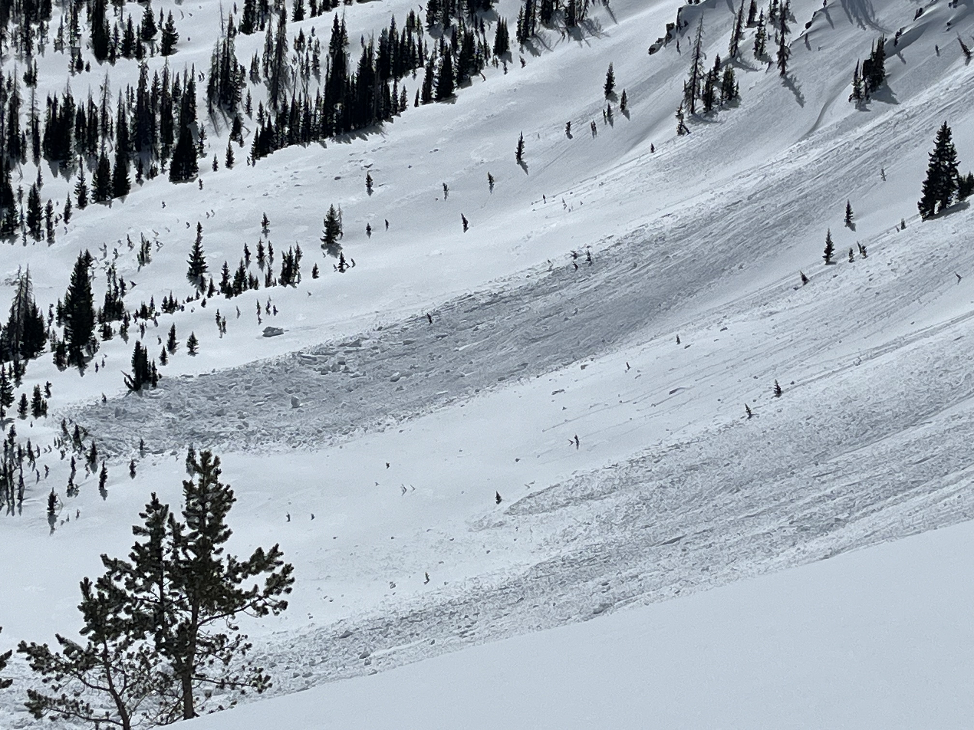
Trevor stomped around Upper Weber Canyon Tuesday afternoon and reported this natural cornice fall which triggered a sizable avalanche as it crashed onto the upper elevation, northeast facing slope below. This slide occurred right around 3:00. With continued heating today, expect more of the same.
Check out all the action, info and intel for the Uinta range and beyond, here.
Ad
Avalanche Problem #1
Wet Snow
Type
Location
Likelihood
Size
Description
Bo reported this wet slide peeling off a steep, southwest facing slope during Tuesday's intense afternoon sunshine. Initiating a point release, this gooey slide stacked up an impressive amount of wet, cement-like debris as it fanned out onto the slope below. The arrow points to a person for scale.
All aspects and elevations take on heat today and the name of the game is to get on the snow early and move to another activity before the snow gets too manky. In addition, think about your end of the day exit strategy and avoid terrain traps like gullies and road cuts, where even a small slide can pile up unusually impressive piles of tree snapping debris.
Ted was on the east side of the range on Monday and noted a large cornice failing naturally during the heat of the day, stacking up a sizable amount of day ruining debris.
Avalanche Problem #2
Persistent Weak Layer
Type
Location
Likelihood
Size
Description
The recent stretch of warm weather may reactivate persistent weak layers, especially in shallow snowpack zones like terrain that has avalanched multiple times this season. Remember... our PWL problem child is still trying to figure itself out and isn't entirely comfortable in its own skin, so here's some considerations-
  • We are not going to see obvious red flags like cracking, or hear big, booming collapses. So... with the high price of eggs, let's not put all of them in one observation basket :)
  • If you pull out your probe and find a shallower area of the snowpack (100-175cms) dig around or trench down, you'll see this weak snow.
  • This problem exists in a small and isolated portion of our terrain and is easily avoidable.
  • Big triggers can produce big avalanches -- Watch out for cornice failure or rapid change... anything that could help pry out one of these nasty slides.
Additional Information
General Announcements
We are always looking for snow and avalanche observations or just general riding conditions. In the meantime reach out to us with questions, concerns, or if you see anything in your travels! Contact us directly through the info below:
This forecast is from the U.S.D.A. Forest Service, which is solely responsible for its content. This forecast describes general avalanche conditions and local variations always occur. This forecast was issued on Thursday, March 27th at 03:30 AM and expires 24 hours after it was issued.