Forecast for the Uintas Area Mountains

Craig Gordon
Issued by Craig Gordon for
Sunday, March 26, 2023
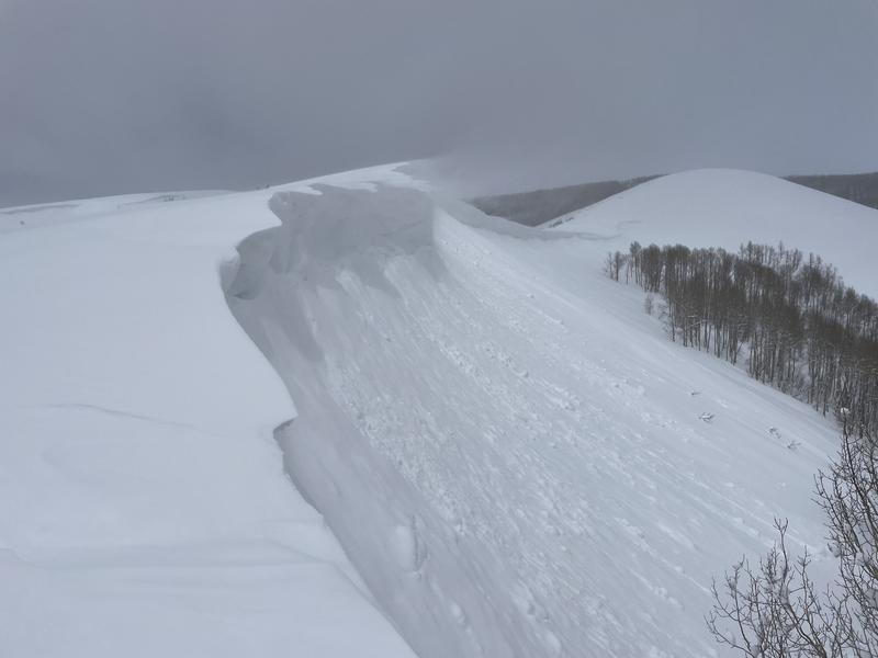
Avy danger remains tricky in the Alpine-
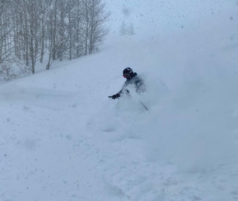
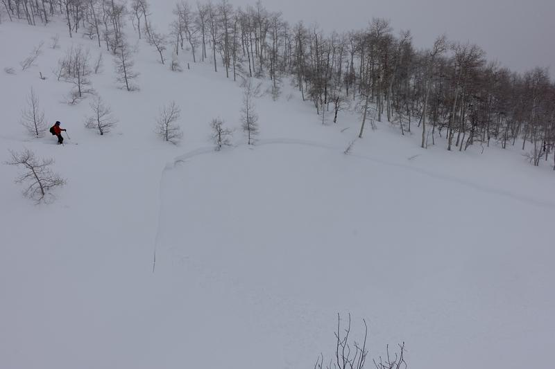
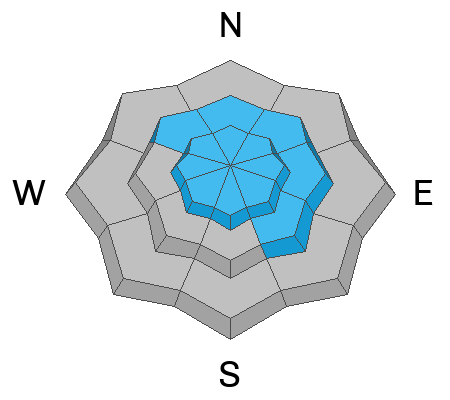
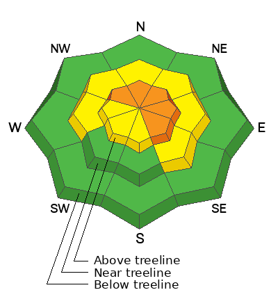
For today, you'll find CONSIDERABLE avalanche danger on steep, rocky, upper elevation, leeward slopes. Human triggered avalanches are LIKELY on drifted slopes in the wind zone above treeline. Terrain facing the north half of the compass, especially steep slopes with an easterly component to its aspect have the potential to produce avalanches that'll pack a punch and throw a curveball at your day. MODERATE avalanche danger is found near treeline and human triggered avalanches are POSSIBLE on steep slopes with recent deposits of wind drifted snow.
Looking for an exit strategy? Well, you came to the right place! LOW avalanche danger exists on lower elevation terrain around the dial, where you can have a blast and score deep, cold, surfy snow along with predictable avalanche danger, particularly in wind sheltered terrain with no overhead hazard.

Low
Moderate
Considerable
High
Extreme
Learn how to read the forecast here
Special Announcements
Thank you to everyone who donated to our Spring Campaign. We appreciate your support and look forward to creating new tools to help you stay safe in the backcountry.
Also... I am in the process of finalizing a report regarding the March 9th avalanche fatality in the Uinta's. Thank you for your patience... we will publish the final report in coming days.
Weather and Snow
Nowcast- A short-lived break in the action late last light was just that... short-lived! So, in the spirit of a busy storm track, at o'dark thirty this morning, high clouds begin to slide into the northwest corner of the state. Cold air settled into the region overnight with temperatures hovering at or slightly below zero degrees. Winds are variable and unbelievably light, blowing less than 10 mph even along the high ridges. And then there's the riding conditions... with a record deep, robust, go-anywhere base, riding and turning conditions are all time.
Forecast- Look for increasing clouds with a few flurries developing right around suppertime as a weak system wiggles through the area delivering a couple inches of snow as temperatures barely crack into the mid teens. West and southwest winds bump slightly into the 20's and 30's as the day wares on.
Futurecast- A break in the action is on tap beginning the workweek and an active pattern develops for midweek.
You wanna rally? Well then don't forget to invite avy-savvy, Bill Nalli. A beautiful human who brings boat loads of stoke, a wealth of information, and an immense love for sharing the sport and the snowcraft :)
Detailed trip reports and recent obs are found HERE.
Recent Avalanches
A little heat ties everything together and the right placed thump brings recent storm slab avalanches to life like this piece of snow yesterday on a steep, mid elevation, westerly facing slope.
Plenty of avy activity to peruse if ya wanna geek out. Click HERE to track this years slide activity throughout the range.
Ad
Avalanche Problem #1
Wind Drifted Snow
Type
Location
Likelihood
Size
Description
Yesterday's wind (blowing left to right in the image above) had no problem stripping snow from the windward side of the ridge and depositing it on the leeward side. I found mid elevation corni super reactive to my additional weight and also a solid indicator to the predominate direction of winds and where I will find fresh drifts reactive to my additional weight.
Recent winds helped reshape the eastern front landscape. When you have a little wind, it's a game changer.... a lot of wind... and fresh wind drifts form at alarming rates. With no shortage of snow available for transport, today's avalanches might not be as hair trigger as yesterday, but they'll react to our additional weight none-the-less and once triggered, they're gonna pack a dangerous punch. What's the strategy to manage the problem? Avoidance, of course! Yeah, simply pump the brakes on the big terrain and tone down your objectives because I guarantee there's a piece of snow out there that'll break deeper and wider than we might expect. Steep, rocky, upper elevation, wind drifted slopes facing the north half of the compass are bulls-eye terrain today. Lose the wind and you lose the problem... plenty of great, wind sheltered riding options are found on lower angle slopes, especially those with no overhead hazard.

Additional Information
Weather stations-
And... rime events from January's atmospheric rivers severely crippled the Uinta weather station network. I'm working to get it back up and running, but a few stations are found HERE (click weather stations, and then on the Western Uinta tab)
Last week I visited our Currant Creek Snow site and of course... it was buried! I'm still trouble shooting comms and working to get everything back online.
Observations-
Your observations are important, so please let me know what you're seeing... click HERE and contribute to this amazing community-based program
General Announcements
Issued at 03:07 on Sunday March 26th this forecast expires 24 hours after the date and time posted, but will be updated by 07:00 Monday March 27th 2023.
Before it gets too crazy, now is the time to book an avalanche awareness presentation for your group, club, or posse. You can reach Craig directly at 801-231-2170 or [email protected].

This forecast is from the U.S.D.A. Forest Service, which is solely responsible for its content. This forecast describes general avalanche conditions and local variations always occur.