March Kicks Off Our Spring Campaign- Donate Now to Support Forecasting

Forecast for the Uintas Area Mountains

Craig Gordon
Issued by Craig Gordon on
Wednesday morning, March 25, 2020
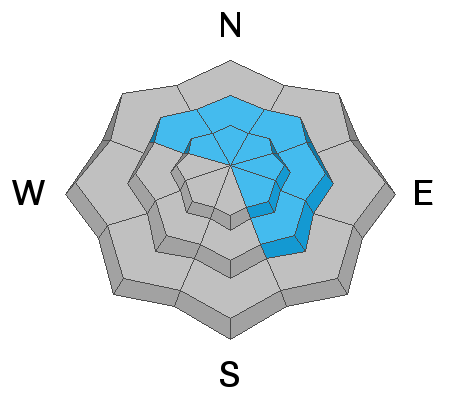
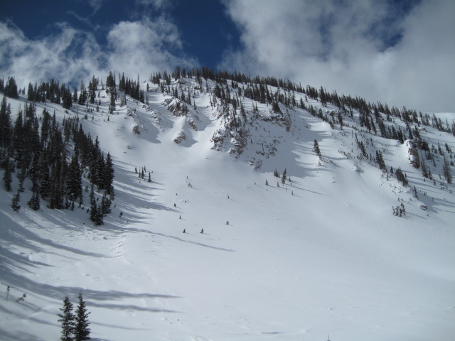
In the wind zone, at and above treeline, MODERATE avalanche danger exists in wind drifted terrain facing the north half of the compass. Human triggered avalanches are possible, especially on steep leeward slopes, particularly those with an easterly component to its aspect. Any slide triggered is gonna pack heat, it'll let you know who's boss, and will instantly ruin a good day of riding.
Lose some elevation, you lose the problem, and still have a great day of riding. Wind sheltered mid and low elevation terrain offers generally LOW avalanche danger.
Low
Moderate
Considerable
High
Extreme
Learn how to read the forecast here
Special Announcements
UAC operating schedule - We will continue issuing regular avalanche forecasts into mid April.
Spring Awareness Campaign - The UAC counts on donations from the backcountry community. We know these are uncertain times and any donation during our awareness campaign will help us continue providing avalanche forecasting and education.
CDC Guidelines - Even in the backcountry and in parking lots, please follow CDC guidelines like limiting group size and keeping a distance of at least 6 feet from other people to protect yourself and others. Read the guidelines HERE.
Taking risks - Be extra conservative to avoid the risk of accidents which can stress the capacity of our medical system.
Skiing and riding at closed ski resorts - Some resorts allow access now and some do not. Please check HERE for the latest info on ski area access.
New to the backcountry (including riding at closed resorts) - Watch the award-winning, 15 minute Know Before You Go video, or take the 5-part, free online-learning series.
Weather and Snow
Currently-
A solid slug of moisture blossomed just before midnight and continues to materialize over the region, so far delivering 3" of medium density snow. Current temperatures register in the teens and mid 20's. Southwesterly winds overshadow snow totals with hourly averages in the 40's and gusts in the 60's and 70's along the high peaks. It'll be a bit rugged near the ridges and in big, open terrain this morning, so steer towards mid elevation, wind sheltered slopes and you'll find late March snow is about as good as it gets.
Uinta weather network info is found here. Simply click on the Western Uinta tab.
For today-
Heavy snow continues this morning with an additional 3"-6" stacking up. Snow begins to taper off and turn showery by early afternoon. High temperatures bump into the low 30's. West and southwest winds should taper off somewhat as the day progresses, though remain a nuisance along the high peaks, blowing in the 40's and 50's.
Futurecast-
The graphic above lays out the timeline for the next few days. The storm ramps up again later today and another round of heavy snow is expected tonight into Thursday morning. Lingering showers continue through Thursday with a drying trend slated for Friday.
Recent Avalanches
No significant avalanche activity to report.
To view additional trip reports and recent avalanche activity, simply click here.
Ad
Avalanche Problem #1
Wind Drifted Snow
Type
Location
Likelihood
Size
Description
Ted was in the Moffit Drainage yesterday and noted a deep, solid, stable snowpack with mostly "green light" avy danger. And on a go anywhere base, it's easy to tag big terrain around the range like in the image above. However, that was so yesterday and now it's time to recalibrate because last nights storm delivered a one-two punch of strong winds and a solid shot of snow. This not only changes the landscape, it also means avalanche danger has risen accordingly. Yup, the days of just pull the trigger, ride it if it's white are rapidly coming to an end. Today, expect evolving avalanche conditions as strong winds whip up a fresh round of drifts. And while we're not measuring snow in feet, remember, it's the wind that makes the western Uinta's a particularly tricky range for avalanches.
And here's the deal.... as the storm materializes, snow stacks up and winds continue blowing, and that creates stiff pieces of snow, which by days end, become more reactive to our additional weight and begin breaking deeper and wider than we might expect. So, the key to riding safely today is... be flexible with your travels plans and adjust objectives if you're starting to see or feel obvious clues to unstable snow like shooting cracks, sudden collapses, or the biggest clue to avalanches and of course, that's avalanches!
General Announcements
The information in this forecast expires in 24 hours, but will be updated by 7:00 AM Thursday Mar. 26th.
This forecast is updated daily by 7:00 AM.
In the mean-time, if you see or trigger an avalanche or just wanna let me know what you're seeing you can reach me directly at 801-231-2170
The information in this forecast is from the US Forest Service which is solely responsible for its content.