Donate to Our Spring Campaign or Bid on our Spring Auction to Support Forecasting

Forecast for the Uintas Area Mountains

Craig Gordon
Issued by Craig Gordon on
Friday morning, March 21, 2025
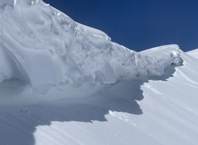
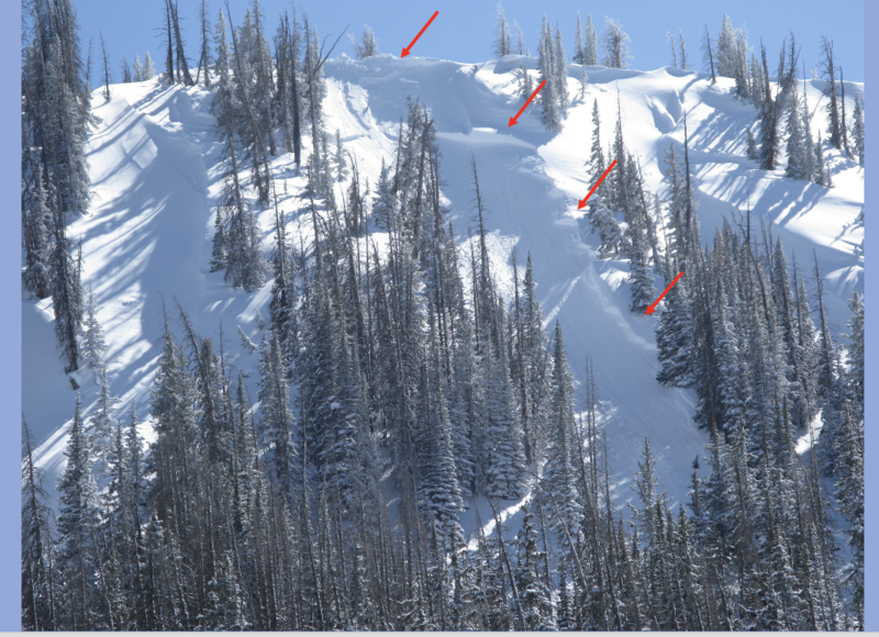
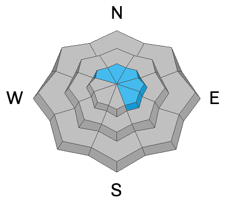
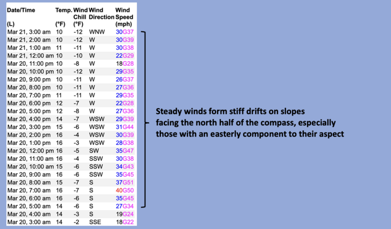
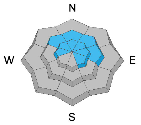
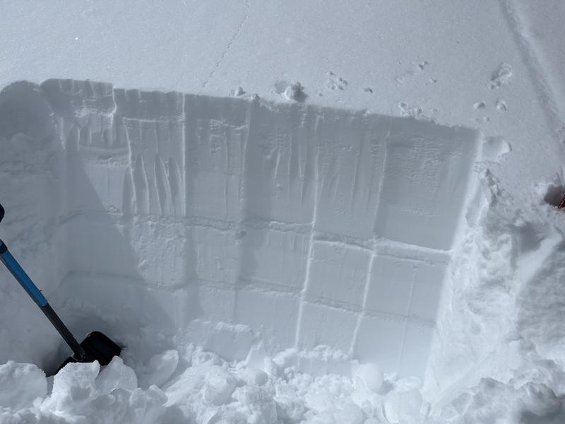
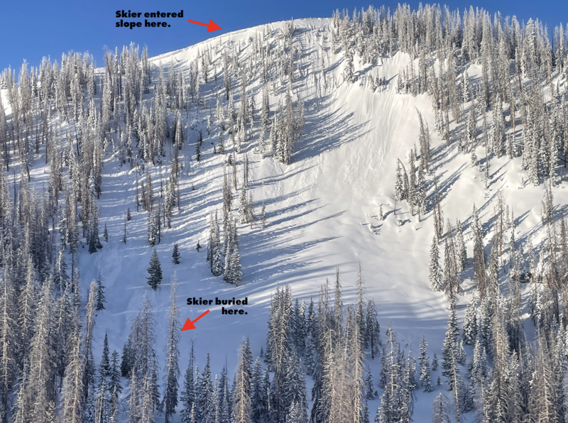
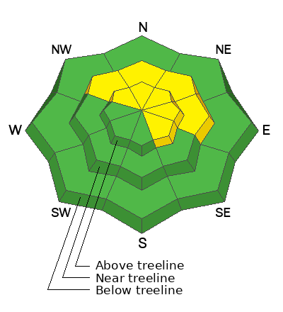
In the windzone at and above treeliine, you'll find MODERATE avalanche danger on slopes facing the north half of the compass, especially those with an easterly component to their aspect. While today's stiff wind drifts are generally stubborn, they will react to our additional weight and human triggered avalanches are POSSIBLE. And remember... faceted snow still exists in terrain harboring a shallow snowpack. Pulling on the avalanche dragons tail in steep, rocky terrain or slopes that have avalanched early in the season can result in a slide that fails on old snow and breaks deeper and wider than we might expect, delivering an instant buzz-killing, body-bruising end to our day.
Most slopes facing the south half of the compass (solar) and lower elevation shady (polar) terrain offers generally LOW avalanche danger and human triggered avalanches are UNLIKELY.
Low
Moderate
Considerable
High
Extreme
Learn how to read the forecast here
Special Announcements
Our Spring Campaign is in full swing, and there are two great ways to support forecasting, awareness, and education across Utah: Donate to our Spring Campaign or bid on items in our Spring Auction
Every dollar helps keep the backcountry community on top. Thank you for your support!
Weather and Snow
Nowcast- A blast of cold air slid through the Uinta's overnight, ushering out the remnants of yesterday's storm and delivering clear skies at o'dark thirty. Remote weather stations across the range grind out the last couple hours of the graveyard shift, recording temperatures in the low teens, while westerly winds steadily blow in the 30's near the high peaks
Forecast- A winter-like personality greets the second day of spring with a quick hitting storm slated to roll through the Uinta region later today. Look for increasing clouds with temperatures rising into the upper 30's. Winds taper off by mid morning, ramping back up late this afternoon. Light snow begins falling late in the day as overnight temperatures dip into the low 20's
Futurecast- Not a big weekend storm, but a nice reset for tonight through Saturday. I'm cautiously optimistic we'll stack up 8" of snow before high pressure builds to round out the weekend. It's high and dry deep into next week.
Travel & Riding Conditions-
Cornices have grown exponentially in size. And while not particularly tender, slipping off one of these boxcar pieces of snow would feel like an unexpected elevator ride to the ground floor.
Recent Avalanches
A day old, but noteworthy none-the-less. This pockety, yet meaty slab was triggered Wednesday by cornice fall, on a very steep, northeast facing slope at 10,400' in Upper Humpy Basin. Breaking 4' deep x 100' wide and failing on the early February facet/dust layer, this avalanche was packing heat and could've easily ruined your day if it clobbered you on the slope below.
Ad
Avalanche Problem #1
Wind Drifted Snow
Type
Location
Likelihood
Size
Description
A 24 hour data dump from Windy Peak (10,662') recording average wind speed, gusts, and direction.
Winds have been the big headline news for the past 24 hours, finding what little snow there is available to blow around and form a fresh drift or two on upper elevation leeward slopes. I suspect today's drifts are hard, stubborn, and will feel solid and good to go underfoot. However, don't let your guard down, especially in the windzone above treeline, where a fresh wind slab could definitely pack a bigger punch then you might've bargained for. You know the program... lose the wind and you lose the problem. Simply steer yourself away from fat, rounded pillows of snow and towards wind sheltered terrain. You reduce the hazard, yet increase the chances of having an even more epic day... done and done.
Avalanche Problem #2
Persistent Weak Layer
Type
Location
Likelihood
Size
Description
Avy-savvy, Uinta forecaster Ted Scroggin knows the eastern front like no one else, stomped around Gold Hill yesterday and reports encouraging news for our snowpack problem children... "A quick pit on this east facing slope in Gold Hill showing a couple of the recent crust layers, but I was not finding any weak snow issues around them. My column tests just smashed down with progressively harder hits."
Becoming more the exception than the rule, recent storm snow and wind have the potential to wake up the PWL avalanche dragon today, especially in terrain that has remained thin all season like slopes that avalanched earlier this winter. Here's the deal and here's where it gets tricky... we're not going to see obvious red flags like cracking, or hear big, booming whoomphing sounds or experience heart-stopping collapses. However, if you do some detective work and trench down a bit you'll find weak, faceted snow buried a couple feet below the snow surface. We might forget about the layering, but recent avalanches breaking to these layers tell us the snowpack has an amazing memory.
Additional Information
  • We come to you with heavy hearts and great sadness this morning to confirm an avalanche accident on Friday, March 7th near Hoyt Peak, involving 51 year old Micheal Janulaitis from Marion, Utah. Micheal used a snowbike to access the terrain, but was caught, carried, and killed in an avalanche while skiing a steep, northeast facing run on Hoyt Peak.Huge thanks to the Department of Public Safety, Park City Mountain Resort and Canyons Village Snow Safety and Ski Patrol teams, along with Wasatch Backcountry Rescue for the hard work recovering Micheal and returning him to his family. Micheal was a friend of Utah Avy and we feel privileged for the time we got to spend together. This is a tremendous loss for our backcountry family and we will miss him deeply. We are compiling accident details and a preliminary report is available here.
General Announcements
We are always looking for snow and avalanche observations or just general riding conditions. In the meantime reach out to us with questions, concerns, or if you see anything in your travels! Contact us directly through the info below:
This forecast is from the U.S.D.A. Forest Service, which is solely responsible for its content. This forecast describes general avalanche conditions and local variations always occur. This forecast was issued on Friday, March 21st at 03:30 AM and expires 24 hours after it was issued.