Forecast for the Uintas Area Mountains

Craig Gordon
Issued by Craig Gordon for
Monday, March 21, 2022
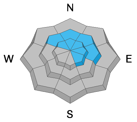
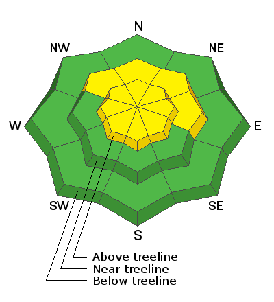
Today you'll find MODERATE avalanche danger and human triggered avalanches are POSSIBLE, but for two very distinct avalanche dragons.
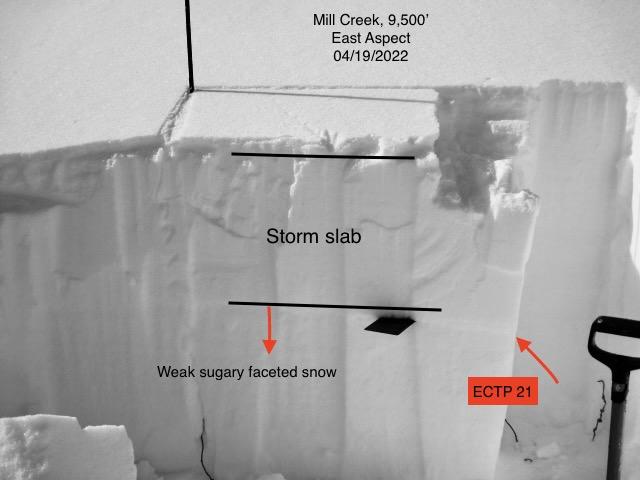
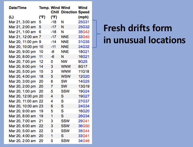
First the manageable... fresh drifts near and above treeline will react to our additional weight and may break a bit deeper and wider than you might expect. Next, the unmanageable... avalanches breaking 2'-3' deep and failing on our persistent weak layer, may be a bit more stubborn to trigger, but they'll pack a powerful punch, especially in terrain near and above treeline on slopes facing NW-N-NE-E.
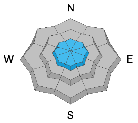
Slopes facing the south half of the compass at mid and low elevations offer LOW avalanche danger and human triggered avalanches are unlikely.

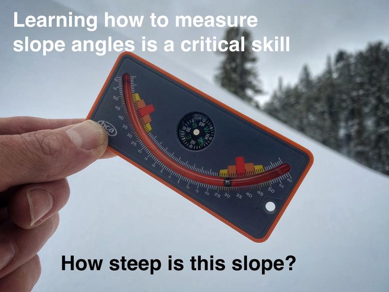
Scroll to the bottom for a note on slope angle and how to have a blast without entering avalanche terrain.
Low
Moderate
Considerable
High
Extreme
Learn how to read the forecast here
Special Announcements
Please help support avalanche forecasting throughout Utah. For more deets about the Spring Campaign to help raise funds and support the forecasting you rely on simply click HERE.
Weather and Snow
NOWCAST-
Yesterday's underwhelming storm only delivered a couple inches of snow, yet over delivered northerly winds which blow in the 30's and 40's near the high peaks this morning. Skies are partly cloudy and winter-like temperatures generally register in the teens, with single digits along the ridges. There's a myriad of snow surface conditions, though with a little hunting, patches of soft powder are still found on wind and sun sheltered north facing slopes.
FORECAST-
Look for mostly sunny skies with temperatures climbing into the mid and upper 20's. Northerly winds blowing in the 30's are gonna be a bit of a buzz-kill if you're stomping around near the high ridges. Under clear skies, overnight lows dip into the teens.
FUTURECAST-
Warm, dry, high pressure takes command of the weather steering wheel through midweek with clouds and cooler air drifting into the region Thursday/Friday.
As for snow conditions- late last week we took the old school bus out for a few laps and found you've gotta be on your game this time of the year as the sun is high in the sky and it has baked all but the most northerly facing slopes in the alpine. But don't let your soft snow heart be troubled, there are large swaths of shallow, cold snow... just don't stray too far off aspect or you'll be dealing with varying degrees of breakable crust.
Trip reports and snowpack observations are found HERE.

Looking for real-time temps, snow, or wind? Click HERE and then on the "western Uinta" tab for western Uinta specific, weather station network.
Recent Avalanches
Other than a few pockety slabs provoked in obscure, high elevation, north facing terrain, it's been rather quiet for nearly a week. Below is a list of avalanches from last weeks active cycle-

Your input is vital and we're interested in what you're seeing. Please contribute to this great community resource and go here to fill out an observation.
Ad
Avalanche Problem #1
Persistent Weak Layer
Type
Location
Likelihood
Size
Description
Ted's image above from his travels Friday around Millcreek illustrate our problem, a persistent weak layer (PWL) buried underneath about 2 feet of snow. It's a stronger snow on weaker snow combo and that setup is causing the increase in avalanche activity. And while recent warm weather is helping our new problem child adjust, gain a little strength, and become happy in its own skin, it hasn't gone away. What this means is that the likelihood of triggering an avalanche on this layer has decreased somewhat, but we know the safest approach is to assume the PWL remains guilty until proven otherwise.
Where does this weak layer exists? The bullseye locations are basically all slopes with dry powder near and slightly below treeline today. Above treeline, the PWL is not as uniform and a little more pockety in distribution. The scary part about this situation is that this layer and it's ability to produce avalanches is variable.
How to avoid it? There are two options. (1) Ride south facing slopes where this layer doesn't exist but the riding conditions are variable. Or, (2) ride northerly facing slopes with dry powder but avoid being on or under any slope steeper than 30 degrees.
Ted and I were grabbed the video below, recapping the snow structure from our field day in upper Chalk Creek last week.
Avalanche Problem #2
Wind Drifted Snow
Type
Location
Likelihood
Size
Description
Above is a 24 hour data dump from Lofty Lake Peak (11,186') showing recent north and northeast wind trends.
Winds have been all over the compass the past 24 hours, and this mornings northeast wind formed shallow drifts in unusual locations. You know the drill... look for and avoid any fat, rounded piece of snow, especially if it sounds hollow like a drum. Lose the wind and you lose the problem... simply lose some elevation and you'll avoid get pounded by the wind and score some quality riding to boot!
Additional Information
AVALANCHE TERRAIN:
Slope angle determines where avalanches can happen and where they can't. Generally, any slope steeper than 30 degrees is where avalanches occur. This means all you need to do is ride slopes less than 30 degrees in steepness and you'll never have to deal with avalanches.
There's a catch! You can't be underneath slopes steeper than 30 degrees either, even if you're on a flat slope, because avalanches can crash down on you. It turns out that skiing or riding slopes about 25 degrees in steepness is really fun and even more fun because there's no worry of avalanches. Unfortunately, it takes a lot of practice to estimate slope angles with your eyes alone. The way to get practice and the only way to know for sure is to measure slope angles with slope measuring tool shown in the photo below, and Toby describes it in this video. There are also many apps so that you can use your phone in a similar manner.

Your observations are important, so please let me know what you're seeing... click HERE and contribute to this amazing community based program
General Announcements
The information in this forecast expires 24 hours after the day and time posted, but will be updated by 07:00 Tuesday, March 22nd.
Before it gets too crazy, now is the time to book an avalanche awareness presentation for your group, club, or posse. You can reach me directly at 801-231-2170 or [email protected]
This forecast is from the U.S.D.A. Forest Service, which is solely responsible for its content. This forecast describes general avalanche conditions and local variations always occur.