Forecast for the Uintas Area Mountains

Craig Gordon
Issued by Craig Gordon for
Thursday, March 16, 2023
Please don't let sunny skies and fresh snow cloud your decision making today... sketchy avalanche conditions still exist-
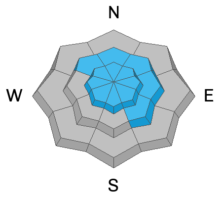
Pockets of CONSIDERABLE avalanche danger are found on steep, upper elevation leeward slopes, especially those in the wind zone facing the north half of the compass. Recent, and older wind drifted slopes remain suspect and human triggered avalanches are LIKELY, particularly in terrain with an easterly component to their aspect. Lingering instabilities at mid elevations produce MODERATE avalanche danger and human triggered avalanches are POSSIBLE on steep slopes with recent deposits of wind drifted snow.
If you're looking for LOW avalanche danger, remember the Uinta's have plenty of low angle, roly-poly terrain. Human triggered avalanches are UNLIKELY on most lower elevation slopes facing, particularly those facing the south half of the compass.

Low
Moderate
Considerable
High
Extreme
Learn how to read the forecast here
Special Announcements
I am currently working with the operation involved in the March 9th avalanche accident in Weber Canyon and preparing a report. Please be patient as I sort out the details of this complicated incident. A preliminary report is available HERE.
Weather and Snow
Nowcast- Yesterday's storm delivered a nice shot of North Slope enhanced snow, stacking up 10" with just about .80" H2O. Sorry south half of the range... this storm cast shade on yo' terrain with half that amount. In either case, skies cleared overnight, delivering an absolutely beautiful morning with crisp temperatures registering in the teens at the trailheads and single digits near the ridges. Winds are light and it's a delicate ballet as they dance between east, north, and northeast, blowing just 5-15 mph near the peaks. Lower elevation solars took on a taste of strong spring sun late in the day and they'll have a crust this morning, but swing around to wind sheltered polars and you'll be rewarded with cold, creamy snow.
Forecast- I hope you're taking full advantage of the mountain therapy bank account and getting into the hills today, cause it's gonna be a beaut! Sunny skies, fresh snow, and temperatures rising into the upper 20's await your arrival. Northerly winds might become a bit pesky later today, as they blow in the upper 20's near the high ridges. About the same weather for Friday with a weak system slated for the weekend.
Futurecast- Long duration storminess is expected next week, with the potential for yet another AR.... yes! This storm trends colder than this last one and I'll keep ya update as deets unfold.
Detailed trip reports and recent obs are found HERE.
Recent Avalanches
No recent avalanche activity to report, but plenty of avy activity to peruse if ya wanna geek out. Click HERE to track this years slide activity throughout the range.
Ad
Avalanche Problem #1
Wind Drifted Snow
Type
Location
Likelihood
Size
Description
Snow is a lot like people and it gets irritable when it goes through a rapid change. But, over time it adjusts and becomes happy in it's own skin. The tricky part is the in-between. So... think Tom Petty here and realize, The Waiting is the Hardest Part. For today, as the snowpack still adjusts to yesterday's rapid load of new snow and wind, steep wind drifted slopes will be in a tenuous balance and reactive to our additional weight. And since the sun and some warming temperatures jump into the mix and sit in for an impromptu jam, they'll throw a wild card at Tom's setlist, adding a familiar, yet pronounced, spring-time variation on an old tune. There's a lot of moving parts, but where the rubber hits the road is... once triggered, I think today's avalanches have the potential to break deeper and wider than you might expect. There's no reason to mess around and pull the avalanche dragon's tail today, because there's plenty of great riding out there on lower angle slopes, especially those with no overhead hazard.

Additional Information
Weather stations-
And... rime events from January's atmospheric rivers severely crippled the Uinta weather station network. I'm working to get it back up and running, but a few stations are found HERE (click weather stations, and then on the Western Uinta tab)
Observations-
Your observations are important, so please let me know what you're seeing... click HERE and contribute to this amazing community-based program
General Announcements
Issued at 03:47 on Thursday March 16th this forecast expires 24 hours after the date and time posted, but will be updated by 07:00 Friday March 17th 2023.
Before it gets too crazy, now is the time to book an avalanche awareness presentation for your group, club, or posse. You can reach Craig directly at 801-231-2170 or [email protected].

This forecast is from the U.S.D.A. Forest Service, which is solely responsible for its content. This forecast describes general avalanche conditions and local variations always occur.