Forecast for the Uintas Area Mountains

Craig Gordon
Issued by Craig Gordon for
Friday, March 15, 2024
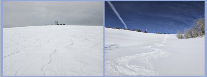
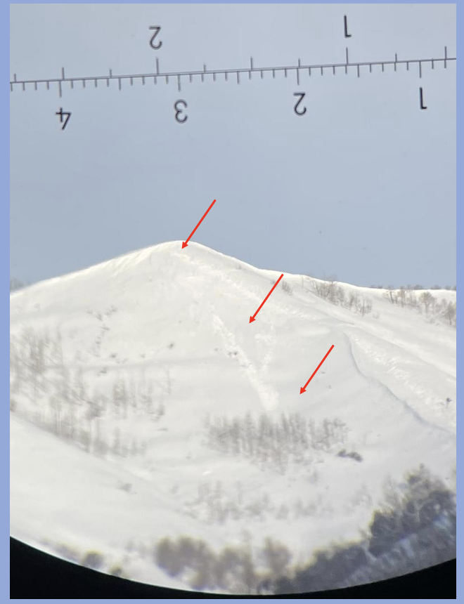
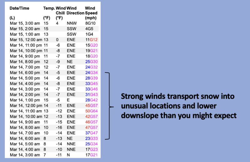
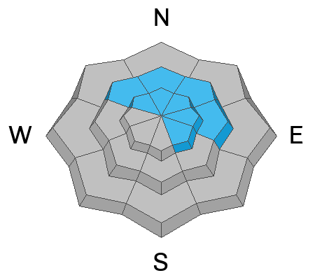
Heads up... unusual wind direction delivers pockets of unusual avy danger-
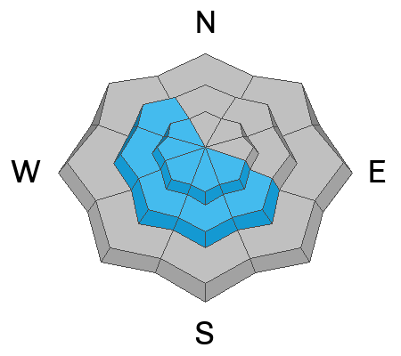
Not widespread and found mostly in the alpine, today you'll encounter pockety CONSIDERABLE avalanche danger in the wind zone, above treeline. Human triggered avalanches are LIKELY, especially on steep, wind drifted slopes, particularly those with a westerly component to its aspect.
Recent winds got into mid elevation terrain where you'll find MODERATE avalanche danger and human triggered avalanches are POSSIBLE on steep wind drifted slopes.
More the exception than the rule, a slide breaking to old snow isn't entirely out of the question, particularly in steep, rocky, wind drifted terrain facing the north half of the compass.
Lose some elevation and head to wind sheltered terrain where you'll find generally LOW avalanche danger.

Low
Moderate
Considerable
High
Extreme
Learn how to read the forecast here
Special Announcements
Please help support the UAC website rebuild by donating to our spring campaign. Save lives by making a donation today!
Weather and Snow
Nowcast- High pressure is beginning to build, but a band of clouds should drift through the region early this morning, courtesy of the low pressure system in the four corners and the storm that clobbered Denver yesterday. While a few inches of snow fell on the east side of range, cold, dry winds blowing in the 50's from the east and northeast, hammered the North Slope. Yep... the needle and the snow damage is done in the alpine, but winds mellowed out at the turn of the new day, they're light and variable, currently blowing just 5-15 mph, while temperatures hover in the low teens. Don't get discouraged by all the blow and little snow... sheltered terrain offers soft, settled snow.
Forecast- Winds blowing from the east and northeast are gonna be obnoxious as they ramp up and blow into the 30's later this morning. But sunny skies and temperatures climbing into the upper 30's should take the edge off and soften the blow.
Futurecast- Expect mostly sunny skies and warming temperatures, while winds remain easterly across the area through the weekend, with some increase in speeds possible Saturday night into Sunday morning. No big storms in sight for the extended, but a return to more consistent storminess is on the horizon about a week out.

Snow-pro Joey Manship was out and about on the south half of the range and reports a mixed bag.
Left image shows wind jacked snow found in open terrain near and above treeline, while the image to the right illustrates creamy pow, a clean slate, and a beautiful signature found on sheltered slopes.... well played Amigo!
Recent Avalanches
Trevor "powder" Katz is a solid snow-pro, long time caller... first time listener, who reports the avalanche in the image above occurred on a steep southerly slope, a result of yesterday's nuking winds.
TK is always on the case and first to report breaking avalanche news. More importantly... Trevor is a kind heart and all around amazing person :)

Meanwhile, last weekend I took a look at a ginormous, boxcar sized cornice which broke unpredictably.

For all Uinta observations and recent avalanche activity click HERE.
Ad
Avalanche Problem #1
Wind Drifted Snow
Type
Location
Likelihood
Size
Description
24 hour Windy Peak (10,662') data dump illustrates the recent wind event
We know winds were invented in the western Uintas and yesterday the range took pride in their patent, nuking into the 50's and 60's along the high ridges from an unusual, east and northeast orientation... yeah, that's odd for us. As such, look for hard and mostly stubborn drifts in uncommon locations, especially on slopes with a westerly component to its aspect. While I suspect most drifting occurred on the leeward side of mid and upper elevation ridges, be on the lookout cross-loading in chutes and gullies and avoid any fat, rounded piece of snow, especially if it sounds hollow like a drum. Breaking at or below our skis, board, or sled today's main avalanche problem is easily managed with terrain choices. Lose the wind... you lose the problem.
Avalanche Problem #2
Persistent Weak Layer
Type
Location
Likelihood
Size
Description
Mark found deep, strong, and stable snow on Saturday during his travels near treeline.
Our snowpack is mostly bomb dot com, but a few Black Swans preen on the shores in shallow aters, though all the right elements for a catastrophic avalanche need to align perfectly. Think... steep, rocky, wind loaded terrain in the windzone, especially slopes that have avalanched multiple times this year. Or in other words... you'd really have to get unlucky. Rather than try to out-guess the snowpack, just keep it simple and avoid places where you think there's a good chance of hitting rocks which in turn are likely places to trigger a deep, dangerous avalanche.
Additional Information
The Uinta weather station network was upgraded this summer and all that real-time info is found HERE. Simply click on "western Uinta" tab and then "weather stations" tab.

We are always looking for snow and avalanche observations or just general riding conditions. So... if you see something, say something. You can reach me directly at [email protected] or 801-231-2170.
Also, if you're looking for more avy education opportunities for yourself, your crew, or your club please don't hesitate to reach out to me and we'll find a presentation, class, or clinic for ya!
General Announcements

Issued at 0400 on Friday, March 15th this forecast will be updated by 0700 Saturday, March 16th, 2024.
This forecast is from the U.S.D.A. Forest Service, which is solely responsible for its content. This forecast describes general avalanche conditions and local variations always occur.