March Kicks Off Our Spring Campaign- Donate Now to Support Forecasting

Forecast for the Uintas Area Mountains

Craig Gordon
Issued by Craig Gordon on
Monday morning, February 10, 2020
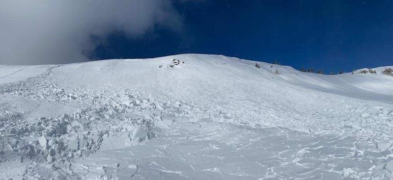
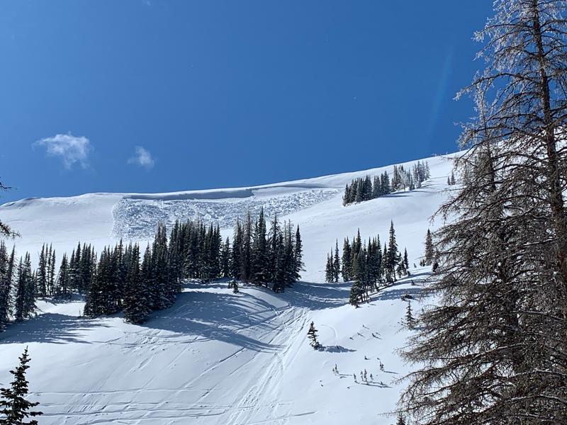
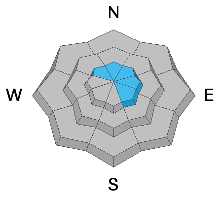
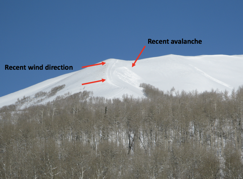
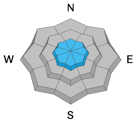
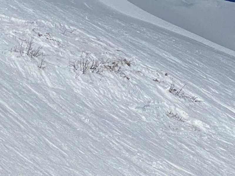
In the wind zone at and above treeline, the avalanche danger is CONSIDERABLE. Human triggered avalanches are LIKELY on steep, wind drifted slopes, especially those with an easterly component to its aspect. While more the exception than the rule, avalanches breaking into deeper, buried weak layers remains a distinct possibility. Usual suspects include- steep, rocky, upper elevation terrain, especially slopes exhibiting a thin, shallow snowpack. Remember- any slide that breaks to old snow, instantly throws a curve ball at your day.
While not nearly as widespread, mid elevation terrain got in on the act too and a MODERATE avalanche danger exists on steep wind drifted slopes where human triggered avalanches are POSSIBLE.
Lose the wind and you lose the problem Wind sheltered mid and low elevation terrain offers generally LOW avalanche danger.
Low
Moderate
Considerable
High
Extreme
Learn how to read the forecast here
Special Announcements
Let's visit at Alpha Coffee on Wednesday night where we'll talk about the current state of affairs in our snowpack. It's guaranteed to be informative, it'll definitely be timely, and it might even be entertaining... hope to see y'all there!
Weather and Snow
Currently-
Under clear skies and a big, bright, beautiful moon, temperatures are in the single digits and northerly winds are light, blowing just 10-15 mph even along the high peaks. No new snow fell in the past 24 hours, but riding and turning conditions are excellent right now with wind sheltered, mid elevation terrain offering cold, creamy, carvy snow.... along with a little alliteration :)
Uinta weather network info is found here. Simply click on the Western Uinta tab.
For today-
Mostly sunny skies and cooler temperatures with highs reaching into the mid 20's. Northerly winds blow 15-25 mph along the high ridges.
Futurecast-
A dry cold front slides through the region late Monday bringing enhanced northeasterly flow and a reinforcement of continued colder temperatures. A more active pattern sets up for late in the week.
Recent Avalanches
It was a busy weekend on the eastern front, with multiple sled triggered slides reported across the range.
From yesterday-
The persistent slab in the image above was initiated by the 4th rider on the slope yesterday in the west fork of the Duchesne. Triggered on a steep, heavily wind drifted, southeast aspect, this slide broke 2'-5' deep, 250 yards wide, and most likely failed on the Christmas crust/facet combo.
And Saturday-
A well connected wind drift triggered on the steep northeast face of Double Hill.
To view additional trip reports and recent avalanche activity, simply click here.
Ad
Avalanche Problem #1
Wind Drifted Snow
Type
Location
Likelihood
Size
Description
Follow the wind and you'll find the hazard.
Winds finally relaxed early Sunday morning and that's good news. However, last weeks big storm brought with it several days of nuking winds, coupled with dense, heavy storm snow. The problem is, this combo rests on lighter density snow that fell earlier last week. This of course creates upside-down layering... stronger snow on weaker snow. And while I think recent wind drifts are becoming glued in place and less reactive over time, we also need to remember that as the snow gains strength it will allow us to get onto steeper, more avalanche prone terrain. So let's exercise a little patience, let the snow heal for another minute or two and apply the best rule of thumb to avoid a close call and simply avoid steep wind drifted slopes, especially if they look fat and rounded or feel hollow and sound like a drum. Done and done.
Avalanche Problem #2
Persistent Weak Layer
Type
Location
Likelihood
Size
Description
We can't see weak layers in the snowpack unless we take a minute, get our shovels out, and investigate... but the snowpack has an amazing memory and doesn't forget where these deficits are located. All we need to do is find one inconsistency (like a shallow, rocky section of the slope like in the image above), collapse the pack, and now we're staring down the barrel of a dangerous avalanche.
Right now, most terrain offers a deep snowpack and it's happy in its own skin. Yes, the big storm is over and now I need to think about suspect terrain I want to avoid, and that includes steep, rocky terrain and slopes that avalanched near the ground earlier in the season. Recent avalanche activity involving weak snowpack structure confirms this hypothesis.
Additional Information
Thanks to the generous support of our Utah ski resorts and Ski Utah, we have discount lift tickets available. All proceeds support the UAC. Get your tickets HERE.
Get one of these cool t-shirts to support the UAC and other avalanche centers across the U.S. INFO
General Announcements
The information in this forecast expires in 24 hours, but will be updated by 7:00 AM Tuesday Feb. 11th.
This forecast is updated daily by 7:00 AM.
In the mean-time, if you see or trigger an avalanche or just wanna let me know what you're seeing you can reach me directly at 801-231-2170
This is a great time of year to schedule one of our free avy awareness presentations.
You can email me directly [email protected]
The information in this forecast is from the US Forest Service which is solely responsible for its content.