Check out our Holiday Auction - Sign Up for the Utah Snow and Avalanche Workshop (USAW)

Forecast for the Uintas Area Mountains

Craig Gordon
Issued by Craig Gordon on
Wednesday morning, December 4, 2024
Today's avalanche danger is generally LOW as our persistent weak layer (sugary snow near the ground) is largely dormant. And while human triggered avalanches are UNLIKELY, I'm still practicing due diligence, doing my homework, and gathering as much information about the snowpack before jumping into steep terrain, because I know even a small avalanche is gonna reveal a myriad of season ending obstacles like stumps, rocks, and dead-fall.
Low
Moderate
Considerable
High
Extreme
Learn how to read the forecast here
Special Announcements
Save the dates and please join us this week!
- Avalanche Awareness Week is in full stride and there's statewide events throughout the week, Check out the full list of happenings across the state HERE!
-The week wraps up Saturday December 7th from 4:00-7:45 PM at the University of Utah with our 17th annual Utah Snow and Avalanche Workshop. Deets and tickets HERE!
Weather and Snow
Nowcast-
Dang.... the air is a mess in the valleys. But fortunately, with a bit of elevation gain, we'll be greeted by clear skies and clean air. In fact, ridgetop temperatures register in the low 30's, neck n' neck with current mercury readings from the City of Salt. Winds are light and northerly, blowing in the low to mid teens near the high peaks. Total snow depths register in the two foot range and it's low tide, with no shortage of buried treasures barely lurking under a thin facade of snow. Riding and turning conditions are a mixed bag though low angle meadow skipping on shady slopes is the ticket andstill offers soft, creamy, surface snow on a somewhat supportable base.
Forecast-
Head to the hills and escape the dank, mank, humid stank. Today, look for mostly sunny skies with temperatures climbing into the upper 30's, while overnight lows dip into the upper 20's. Northerly winds blowing 10-15 mph are a non-issue, even near the high peaks.
Futurecast-
Pretty quiet on the eastern front through the upcoming week, though a moisture starved cool front slides through the area on Friday. But wait... there's more! The Sunday storm is starting to offer a glimmer of hope. Not a "call into work sick" kinda day, but perhaps a couple inches of low density snow and some wind to flush out the stagnant air in low laying valleys.
Current conditions-
Andy and I were in the Mill Hollow environs Sunday, enjoying the clear, clean air, soft creamy snow, and yes... the beautiful views weren't too shabby either :)
The always intrepid Trevor Katz stomped around in Soapstone over the weekend and offers a great trip report HERE.
Ted ventured into the cold side of Bald Mountain last Saturday and notes... "Nice surface snow that is starting to weaken, there were some crusted conditions on the sunny slopes and firm wind slabby snow in the exposed terrain. Conditions are still thin and it looks better than it is."
Additional obs and trip reports found HERE.
Recent Avalanches
No new avalanche activity since Wednesday, November 27th near Wolf Creek Pass with several remotely triggered avalanches breaking near the ground on our problem child, a persistent weak layer of snow or what we call PWL.
Archived avy activity found HERE.
Ad
Avalanche Problem #1
Persistent Weak Layer
Type
Location
Likelihood
Size
Description
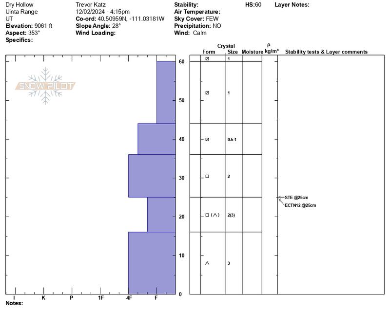
Trevor submitted the snow profile above from the Soapstone environs and comments... "A thin, shallow, weak, trap door, faceted snowpack is present in Dry Hollow. All layers observed contain angular grains of one kind or another, and the snowpack does not support much skier weight as a result."
Our current setup-
It's been a week since our last storm stacked up a respectable amount of snow, water, and wind. The rapid change irritated weak, sugary snow near the ground, making it rather cranky and reactive to our additional weight. In time though, the pack has adjusted somewhat, relaxed a bit, and is becoming comfortable in its own skin. In fact, I suspect there's miles and miles of terrain you can ride safely today. I think you'd be hard pressed to trigger a slide today, but if you're hunting for an avy all you need to do is find a thin spot in the snowpack, maybe around a bush or rock, collapse the slope, and now we're staring down the barrel of a moving piece of snow that could throw a curve ball at my day.
General Announcements
Additional Information
The Uinta weather station network was upgraded this summer and all that real-time info is found here. Simply click on the "Western Uinta" tab and then the "Weather Stations" tab to find all your weather needs.
We are always looking for snow and avalanche observations or just general riding conditions. So... if you see something, say something. You can reach our team directly by contacting Craig at [email protected], 801-231-2170, or Andrew at [email protected], or 860-460-8142.
General Information
This forecast is from the U.S.D.A. Forest Service, which is solely responsible for its content. This forecast describes general avalanche conditions and local variations always occur. This forecast was issued on Wednesday December 4th at 0330 AM and expires 24 hours after it was issued. We will update the forecast by 07:00 tomorrow. But, in the meantime reach out to us with questions, or if you see anything in your travels.