Forecast for the Uintas Area Mountains

Craig Gordon
Issued by Craig Gordon for
Saturday, December 4, 2021
Let's face it... there's hardly enough snow to move around on and you'd really have to go out of your way to trigger a slide. However, a few old wind drifts on the leeward side of the highest terrain may react to our additional weight. And remember... even a small avalanche this time of year will reveal a myriad of season ending obstacles. So, if you're hiking, hunting, snowshoeing or out for a high elevation peak bagging circuit you'll want to look for and avoid any steep, wind drifted slope.
Low
Moderate
Considerable
High
Extreme
Learn how to read the forecast here
Special Announcements
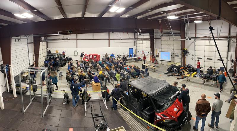
Huge thanks to Wasatch County Search and Rescue and Karl Malone Power Sports of Heber for hosting last nights annual avy awareness class along with Backcountry Institute (BCI) for co-presenting. Of course, we couldn't do all of this without YOU, so a big shout-out to everyone who took time out of their busy lives to learn how to more safely enjoy the Greatest Snow on Earth.
Weather and Snow
NOWCAST-
It's a beautiful morning in the mountains. You wanna escape the valley gunk? Well then, head to the hills where clear skies, light westerly winds, and temperatures in the 30's await your arrival.
FORECAST-
Another round of spring-like day is on tap with mostly sunny skies and high temperatures climbing into the mid to upper 40's. A few clouds may creep into the area late today and winds ramp up tonight with gusts in the 40's and 50's along the high peaks.
FUTURECAST-
A more active weather pattern brings multiple storms to the Uinta zone. The first quick hitting system slides through Monday into Tuesday and should stack up 4"-6" of snow. Clearing is on tap for Wednesday with another storm impacting the area Thursday into Friday.
The image above illustrates snow structure around Reid's Peak where guide, educator, and dad extraordinaire Derek DeBruin has been stomping around for the past few weeks. Check out this great ob and heads up to anyone headed to that zone.
Looking for real-time temps, snow, or wind?
Click HERE and then on the "western Uinta" tab for western Uinta specific, weather station network.
As the seasons change, we're interested in what you're seeing. Go here to fill out an observation.
Recent Avalanches
No recent avalanche activity to report.
Observations, trip reports, and avalanches found here.
Ad
Avalanche Problem #1
Wind Drifted Snow
Type
Location
Likelihood
Size
Description
Ted and I worked on one of our weather stations in upper Whitney Basin this week and then took time to stomp around and get a feel for the snow. And man... has it changed! Yup, our snowpack is beginning to feel the negative effects of the November dry spell as the endless string of clear, cool nights overtakes any warmth during the day. Unfortunately, the snowpack is taking a hard hit. In fact, on some high elevation shady slopes, the snow has grown so weak and sugary just moving around on it offers a challenge unto itself... sorta like wallowing in a sandbox. Not a problem now, but once it starts snowing again... heads up!
Today's avy danger is pretty straight-forward and you'd really have to go out of your way to trigger a slide. The bad news is... even a small wind drift along the leeward side of an upper elevation ridge can easily knock you off your feet and take you for a nasty ride through rocks, deadfall, or stumps.
And remember- just 'cause you can see it from the road doesn't means it's good to go. Our high mountain passes dump us off in avalanche terrain. I think about early season roadside attractions like Murdock Bowl off the Mirror Lake Highway or Wolf Creek Bowl near highway 35 and Wolf Creek Pass. Easy grabs... right? Even though it might not seem like there's enough snow to avalanche, today you'll want to avoid any steep, wind drifted slope.
Additional Information
As the seasons shift we will see you back here more frequently
Your observations are important, so please let me know what you're seeing... click HERE and contribute to this amazing community based program
General Announcements
The information in this forecast expires 24 hours after the day and time posted, but will be updated periodically this week.
I will update this forecast as conditions change and then once winter kicks you can expect the usual daily forecasts issued by 07:00... or perhaps earlier :)
Before it gets too crazy, now is the time to book an avalanche awareness presentation for your group, club, or posse. You can reach me directly at 801-231-2170 or [email protected]
This forecast is from the U.S.D.A. Forest Service, which is solely responsible for its content. This forecast describes general avalanche conditions and local variations always occur.