Donate to Our Spring Campaign or Bid on our Spring Auction to Support Forecasting

Forecast for the Uintas Area Mountains

Craig Gordon
Issued by Craig Gordon on
Monday morning, December 30, 2019
In a sea of generally LOW avalanche danger, there's a few snowpack issues to be aware of...
First-
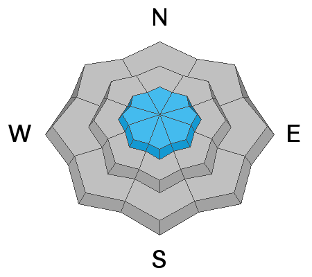
On all aspects of the compass in the wind zone, particularly at upper elevations, a MODERATE avalanche danger exists. This isn't a widespread issue, but human triggered avalanches are possible, especially on steep wind drifted slopes.
Second-
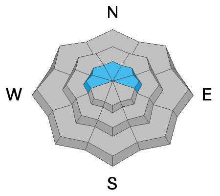
Steep, rocky, upper elevation, shady slopes, with a weak shallow snowpack present a different looking MODERATE avalanche danger. Once initiated, human triggered avalanches failing on weak snow near the ground can break deeper and wider than you might expect.
Finally-
Lose a little elevation and you lose much of the problem. Wind sheltered, low and mid elevation terrain and big open meadows with no steep slopes above or adjacent to where you're riding generally offers LOW avalanche danger and human triggered avalanches are unlikely.
Low
Moderate
Considerable
High
Extreme
Learn how to read the forecast here
Weather and Snow
Currently-
Under mostly cloudy skies, a few light snow showers linger, adding a couple more flakes to the 3" of uber-light snow that fell yesterday. Temperatures are creeping out of the deep freeze and currently register in the single digits. Northwest winds are hardly noticeable, blowing just 5-15 mph even along the high ridges. The range has excellent early season coverage with total snow depths averaging just over 3' of settled snow.
Uinta weather network info is found here. Simply click on the Western Uinta tab.
For today-
Expect morning cloudiness with occasional light snow showers, becoming partly cloudy this afternoon. High temperatures rise into the mid 20's with overnight lows diving into the single digits. Northwest winds remain reasonable, blowing in the teens and mid 20's along the high peaks.
Future cast-
A potent storm system impacts the area New Years Day into Thursday morning bringing a solid shot of snow and water. Not a long duration storm, yet it should stack up a foot or more of snow with an inch of H20. More details on timing and strength for tomorrow's update.
Recent Avalanches
Recent northeast winds drifted snow in unusual locations, creating fresh slabs, reactive to the additional weight of a person. Easy to detect by their fat rounded appearance, this is today's main avalanche issue... see below.
To view trip reports and recent avalanche activity, simply click here.
Ad
Avalanche Problem #1
Wind Drifted Snow
Type
Location
Likelihood
Size
Description
Northeast winds bumped into the 20's and 30's for a few hours Saturday, loading upper elevation terrain in unusual locations and whipping up a fresh round of drifts on slopes with a westerly component to their aspect. While mostly manageable in size, if you're getting into high alpine terrain, today's wind slabs might break a bit wider and deeper than you'd expect and could boss you around. Found along the leeward side of upper elevation ridges and around terrain features like chutes and gullies, your best bet for avoidance is to simply steer clear of any fat, rounded piece of snow, especially if it sounds hollow like a drum. In addition, look for shooting cracks in the snow which are sure signs of unstable conditions.
Avalanche Problem #2
Persistent Weak Layer
Type
Location
Likelihood
Size
Description
All the avy pros I talk with have the same overall feeling about our current snowpack setup.... we're encouraged by what we're seeing. The pack is slowly gaining strength and it's got body. It's not just a pile of weak, lifeless, sugary snow... and that's good news. As a matter of fact, the lack of avalanche activity reveals why it's been nearly 10 days since we've seen or heard of any avalanches failing on weak, old snow layers near the ground. However, our collective gut feeling and snowpack intuition suggests we're not quite out of the woods just yet. And here's why... there's a persistent weak layer near the ground and these weaknesses can take long periods of time to heal. I also know that it might be more difficult to trigger a slide, but once initiated, avalanches have a distinct possibility of breaking deeper and wider than I might expect. Look at where JG's concern is focused on in the pit profile above.
Personally, I don't entirely trust anything in the snowpack I can't manage, so I'm going to continue avoiding terrain that harbors questionable snowpack structure. Of course the usual suspects come to mind... steep, rocky, upper elevation slopes facing the north half of the compass is bulls-eye terrain and should be considered suspect. With all the great coverage across the range and so many other riding options, there's no reason to roll the dice or pull on the dogs tail.
Additional Information
Thanks to the generous support of our Utah ski resorts and Ski Utah, we have discount lift tickets available. All proceeds support the UAC. Get your tickets HERE.
Get one of these cool t-shirts to support the UAC and other avalanche centers across the U.S. INFO
General Announcements
The information in this forecast expires in 24 hours, but will be updated by 7:00 AM Tuesday Dec. 31st.
This forecast is updated daily by 7:00 AM.
In the mean-time, if you see or trigger an avalanche or just wanna let me know what you're seeing you can reach me directly at 801-231-2170
It'll be a minute or two before we're riding, but while you're waiting....
This is a great time of year to schedule one of our free avy awareness presentations.
You can email me directly [email protected]
The information in this forecast is from the US Forest Service which is solely responsible for its content.