Donate to Our Spring Campaign or Bid on our Spring Auction to Support Forecasting

Forecast for the Uintas Area Mountains

Craig Gordon
Issued by Craig Gordon on
Tuesday morning, December 24, 2019
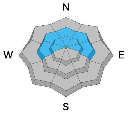
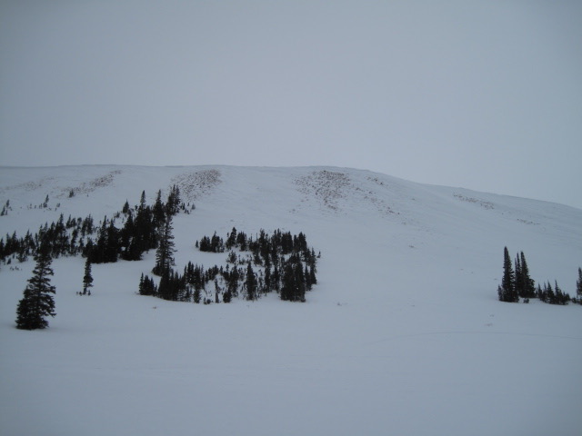
In the wind zone at mid and upper elevations, MODERATE avalanche danger exists for both new and old snow issues. Primarily found on steep slopes facing the north half of the compass, human triggered avalanches initiated on fresh wind drifted slopes and then breaking to old snow near the ground are POSSIBLE, particularly in rocky terrain harboring weak, pre-existing, early season snow.
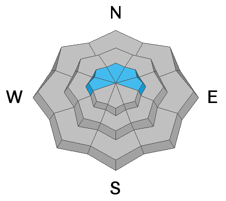
Lose a little elevation and you lose much of the problem. Wind sheltered, low and mid elevation terrain and big open meadows with no steep slopes above or adjacent to where you're riding generally offers LOW avalanche danger and human triggered avalanches are unlikely.
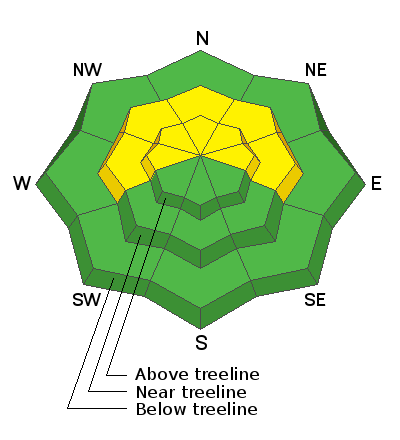
Low
Moderate
Considerable
High
Extreme
Learn how to read the forecast here
Special Announcements
Huge thanks to Andy Nassetta and Kyle Mays for their Herculean efforts yesterday installing both the Are You Beeping sign and Beacon Basin at Nobletts... you guys rock and your hard work is deeply appreciated by everyone in our mountain community.
Weather and Snow
Currently-
While some of us were sleeping, a weak wave of moisture slid through the region late last night, delivering a couple inches of dense snow. Temperatures are in the teens and mid 20's. Southerly winds punish the upper elevations with hourly averages in the 30's, gusting in the mid 50's along the high peaks. There's a lot of wind jacked snow out there, but wind sheltered slopes offer soft, creamy snow. With total snow depths averaging right around three feet, the range has excellent early season coverage.
Uinta weather network info is found here. Simply click on the Western Uinta tab.
For today-
Expect mostly cloudy skies with temperatures climbing into the 30's. Southerly blow in the 30's with gusts near 50 mph. along the high peaks. Overnight we should see a better shot of snow with 5"-10" expected by late Christmas Day... perhaps we squeeze out a foot of snow.
Future cast-
Recent Avalanches
No significant new avalanche activity to report for nearly a week.
To view trip reports and recent avalanche activity, simply click here.
Ad
Avalanche Problem #1
Persistent Weak Layer
Type
Location
Likelihood
Size
Description
It's been nearly a week since we've seen or heard of any avalanches failing on weak, old snow layers near the ground... and that's good news. And while stability tests in our snowpits confirm that the pack is strengthening, I still don't entirely trust it and I'm going to continue avoiding terrain that harbors questionable snowpack structure. Of course the usual suspects come to mind... steep, rocky, upper elevation slopes facing the north half of the compass is bulls-eye terrain and should be considered suspect. With the great coverage across the range and so many other riding options, there's no reason to roll the dice or pull on the dogs tail.
Avalanche Problem #2
Wind Drifted Snow
Type
Location
Likelihood
Size
Description
Overnight, a little bit of snow and continued strong winds created drifts sensitive to our additional weight. While mostly manageable in size this morning, with additional new snow and wind, today's winds slabs might break a bit wider than you'd expect and could boss you around, especially by days end. Found along the leeward side of upper elevation ridges and around terrain features like chutes and gullies, your best bet for avoidance is to simply steer clear of any fat, rounded piece of snow, especially if it looks chalky or sounds hollow like a drum. In addition, look for shooting cracks in the snow which are sure signs of unstable conditions.
Ted was near Double Hill yesterday and noted cross-loading in bowls and chutes facing the north half of the compass. More on Ted's travels and insight found here.
Additional Information
Thanks to the generous support of our Utah ski resorts and Ski Utah, we have discount lift tickets available. All proceeds support the UAC. Get your tickets HERE.
Get one of these cool t-shirts to support the UAC and other avalanche centers across the U.S. INFO
General Announcements
The information in this forecast expires in 24 hours, but will be updated by 7:30 AM Wednesday Dec. 25th.
This forecast is updated daily by 7:30 AM.
In the mean-time, if you see or trigger an avalanche or just wanna let me know what you're seeing you can reach me directly at 801-231-2170
It'll be a minute or two before we're riding, but while you're waiting....
This is a great time of year to schedule one of our free avy awareness presentations.
You can email me directly [email protected]
The information in this forecast is from the US Forest Service which is solely responsible for its content.