AVALANCHE WARNING!! Tap for info

Forecast for the Uintas Area Mountains

Craig Gordon
Issued by Craig Gordon on
Wednesday morning, December 14, 2022
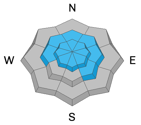
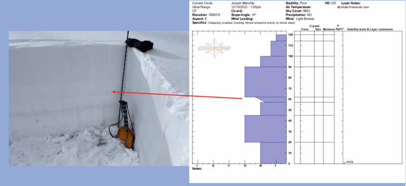
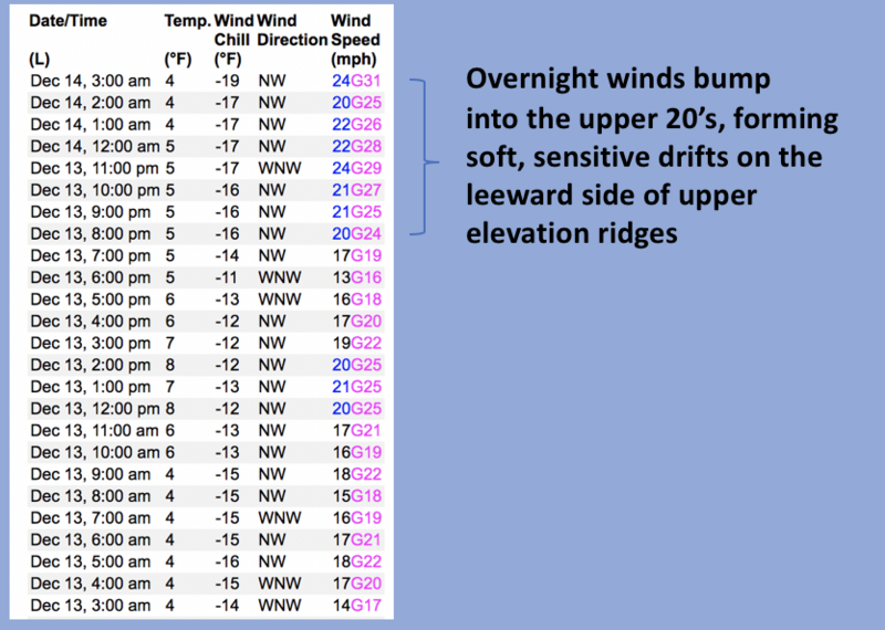
Don't get duped into thinking we're only dealing with light, fluffy, new snow avalanches. Underneath the blower pow, strong snow rests on weak snow... creating deceptively dangerous avalanche conditions-
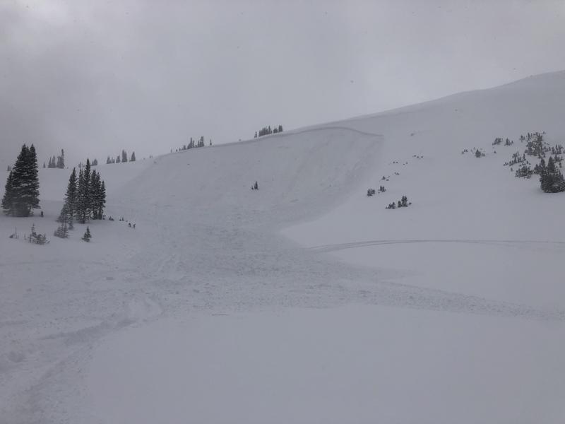
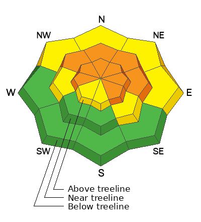
Today, you'll continue finding CONSIDERABLE avalanche danger in mid and upper elevation terrain, especially on slopes facing the north half of the compass in the wind zone at and above treeline. Human triggered avalanches breaking to weak, sugary, midpack snow are LIKELY. Lower elevation shady slopes with similar layering offer MODERATE avalanche danger and human triggered avalanches are POSSIBLE.
LOW avalanche danger is found on low and mid elevation south facing slopes and human triggered avalanches are UNLIKELY.

Wind sheltered terrain with no overhead hazard (meaning, no steep slopes above or adjacent to where I'm traveling) is the hot ticket. I've been finding excellent riding conditions and fun meadow skipping on mellow, wind sheltered slopes with no overhead hazard . Remember, don't get too throttle happy because it's still low tide and there's plenty of reef barely hidden underneath our recent storms. With a significant danger of hitting rocks, stumps, and other obstacles, you'll wanna tone it down today and don't let a buried treasure ruin your season.
Low
Moderate
Considerable
High
Extreme
Learn how to read the forecast here
Special Announcements
Both Mirror Lake Highway and Wolf Creek Pass are closed for the season

Weather and Snow
Nowcast- The North Slope gift that keeps giving.... keeps giving! Man, the fire-hose is focused on Smith-Moorehouse, Upper Weber Canyon, Whitney Basin, and points north where 14" of snow, with just .50" H20 stacked up in the past 24 hours. From Mirror Lake south to Wolf Creek and Daniels, about half of that amount piled up since yesterday at o'dark thirty. Light snow falls from mostly cloudy skies and temperatures hover in the single digits and low teens. Along the high ridges, northwest winds blow in the 20's and low 30's and that equates to a finger numbing wind chill registering to -18 degrees. But I bet you quickly forget the cold because no matter how you cut it, the snow is light, it's deep, and yes... it's over-the-hood and over-the head :)
Forecast- Unsettled weather stacks up another couple inches of snow before tapering off by sunset. High temperatures creep into the teens, whilst west-northwest winds blow in the 30's along the high peaks.
Futurecast- A short-lived break in the action is on tap for tonight with a quick-hitting storm in the queue, slated to move into the region just in time for tomorrows commute. For Thursday, look for increasing wind with 6"-8" of snow stacking up. Clearing weather is on tap to round out the work week.

Lots of excellent trip reports and recent obs are found HERE.
Recent Avalanches
Huge thanks to Dave for reporting yesterday's avalanche from the south end of Double Hill. Sounds like Dave and his crew triggered this slide remotely (from a distance) and low on the slope. Making the setup tricky is.... they already had climbed the hill several times... so there were already tracks on the slope. This speaks to the tricky nature of our snowpack right now. More on this avy found HERE.
Recent avy activity and a slew of Uinta obs are HERE.
Ad
Avalanche Problem #1
Persistent Weak Layer
Type
Location
Likelihood
Size
Description
A pit profile from the Currant Creek zone shows exactly where the weaker, sugary, persistent weak layer (PWL) exists in the mid portion of our snowpack.
The good-
Prior to Sunday nights storm, weak, sugary faceted snow buried in the mid portion of our snowpack was just getting comfortable in its own skin, adjusting to last weeks big storm. And until yesterday, the lack of recent avalanche activity suggested a slow turn towards stability... good news.
The bad-
Southerly winds cranked over the weekend, not only changing the landscape, but also adding an additional layer of strong snow to our pre-existing snowpack. Problem is... all that strong snow rests on weak, sugary, midpack snow (our problem child, the persistent weak layer or PWL) which formed during the mid November drought.
The potentially ugly-
Our recent round of ultra-blower pow isn't going to wake up the avalanche dragon, but pull back the curtain and a more nefarious setup is revealed... and here's what's going on. Last weekends wind formed a dense, strong slab, but that solid layer rests on weaker snow formed during the mid November dry-spell. Now here's where it gets tricky, this setup gives us a false sense of snow stability, because it feels bomber and good to go underneath our skis, board, or sled. In fact, this combo often lures us well out onto steep slopes before weak layers fail, allowing avalanches to break well above us and the whole roof crashes down. So yes, I'm thinking not only about the snow I'm riding in, but also the snow I'm riding on. Here's where the rubber hits the road and what makes things tricky right now... any avalanche that fails near the midpack weakness (PWL), is gonna break deep and wide and it's gonna be dangerous.
Unless you take your shovel out, dig down and investigate a bit, you can easily get lulled into a false sense of snow stability because the snowpack has gained a substantial amount of buoyancy. Yep, that pack's got a whole lotta body... baby :)

Avalanche Problem #2
Wind Drifted Snow
Type
Location
Likelihood
Size
Description
24 hour data dump from Windy Peak (10,662') clearly depicts the recent winds.
Winds have been all over the map, but don't get lured into the thinking fresh snow is the only avalanche game in town. Cold, light, fluffy snow camouflages wind drifts formed over the weekend, making them hard to detect. Here's where it gets tricky... once initiated, this big brother version carries the possibility of snow breaking deeper and wider than we might expect. Found mostly on the leeward side of upper elevation ridges, I'd also be on the look out for drifting around terrain features like chutes and gullies. In either case, you'll wanna look for and avoid any fat looking rounded pillow of snow, especially if it sounds hollow like a drum.
Hot ticket and where to ride-
Easily managed and avoided with terrain choices... lose the wind, you lose the problem, and score great riding conditions to boot. Done, done, and done :)
Additional Information
Sunday nights forecaster discussion ruminating over the currant snowpack setup
And... we were super busy this summer upgrading the western Uinta weather station network and this real-time winter info is found HERE (click weather stations, and then on the Western Uinta tab)
Your observations are important, so please let me know what you're seeing... click HERE and contribute to this amazing community-based program
General Announcements
Issued at 03:58 on Wednesday December 14th, this forecast expires 24 hours after the date and time posted, but will be updated by 07:00 Thursday December 15th.
Before it gets too crazy, now is the time to book an avalanche awareness presentation for your group, club, or posse. You can reach Craig directly at 801-231-2170 or [email protected].

This forecast is from the U.S.D.A. Forest Service, which is solely responsible for its content. This forecast describes general avalanche conditions and local variations always occur.