UDOT PLANNED AVALANCHE CLOSURES!!

Forecast for the Uintas Area Mountains

Craig Gordon
Issued by Craig Gordon for
Wednesday, November 9, 2022
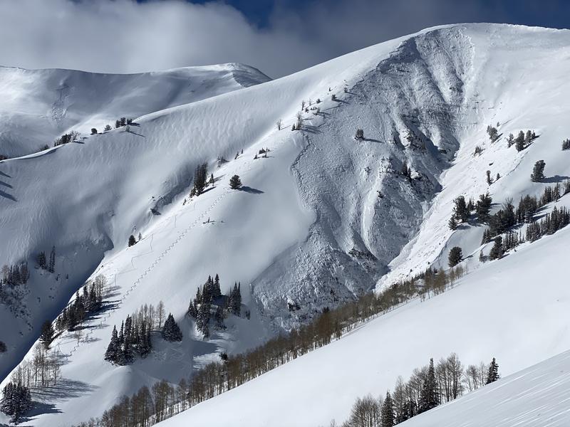
As todays storm evolves, expect changing avalanche conditions and rising danger-
Very strong winds continue building fresh drifts along the leeward side of upper elevation ridges and around terrain features like chutes and gullies. Today you'll want to practice safe travel by avoiding steep, upper elevation terrain, especially slopes facing the north half of the compass. And remember... any avalanche triggered today can result in a season ending, traumatic injury.
Low
Moderate
Considerable
High
Extreme
Learn how to read the forecast here
Special Announcements
SAVE THE DATE and TAKE A DATE... SEE YOU toNIGHT!
Grab your riding posse and sign up for the 15th Annual Utah Snow and Avalanche Workshop (USAW). You've got a couple hours left to join us for an evening of solid avy education, brought to you by a remarkable group of presenters, all delivered virtually to the comfort of your own home... November 9th. Sign up and get more info HERE.
Keep your avy savvy groove goin'-
It's never to early to start thinking about avalanches. A few things to consider doing:
Attend USAW and learn more about avalanches and decision making.
Sign up for an avalanche class.
Take the online courses listed on the KBYG website (Develop skills -> Online Learning).
Get your avalanche rescue gear ready for winter. Put fresh batteries in your transceiver and update the firmware. Inspect your shovel and probe. Get your airbag backpack ready by possibly doing a test deployment and update the firmware if it is an electric version.
Weather and Snow
It might be a bit slickery getting to the trailhead today.
Nowcast- Snow began falling late yesterday afternoon and so far we stacked up 7" across the range. Yep, a bit late to the powder party... the storm is still evolving. Cold air is just beginning to drift into the region, though temperatures currently register in the upper 20's and mid 30's.The big headline news is... 48 hours of southerly winds ripping into the 40's and 50's along the ridges, screaming into the 60's and 70's near the peaks. Total snow depths average 18"-24"... just enough coverage for a few turns on a grassy meadow or a quick rip with the sled on a smooth, rock free road.
Forecast- Winds eventually switch to the west and back off slightly bringing a good shot of snow to the region this morning. We'll see a break in the action with another band of snow slated to arrive late this afternoon. I bet we stack up an additional 8" of snow before things wind down late today and temperatures crater into the single digits.
Furturecast- This storm exits the stadium Thursday and we get a break late in the week through the weekend.
Micheal J stomped around in the Wolf Creek zone Sunday and snagged this pit profile which is quite representative of much of the range.

Recent Avalanches
No recent avy activity to report. Trip reports are found HERE
Ad
Avalanche Problem #1
Wind Drifted Snow
Type
Location
Likelihood
Size
Description
Today's storm snow is no match for strong southerly winds blasting the ridges overnight and this morning. Windy Peak (10,662') clearly depicts the story in exposed terrain.
Travel is pretty limited to upper elevation terrain. But here's the problem... that's exactly where today's hazard exists, especially on steep wind drifted slopes facing the north half of the compass. Today's avy conditions are on the verge of becoming tricky as the snow feels solid underneath our skis, board or sled. And while most of our snowpack is welded in place, I bet a few fresh wind drifts react to our additional weight. Best bet for today is avoiding any fat, rounded pillow of snow, especially if it sounds hollow like a drum. Once triggered, today's avalanches have the potential to break deeper and wider than you might expect. Remember, even a small wind drift can easily knock you off your feet and slam you into a group of trees or over a cliff band.
Additional Information
Of course, early season roadside attractions like Murdock Bowl off the Mirror Lake Highway or Wolf Creek Bowl along Highway 35 become likely suspects as roadside, park n' ride grabs. Here's the deal... just 'cause you can see it from the road, that doesn't necessarily mean it's safe and good to go.
And we've been super busy this summer upgrading the western Uinta weather station network and this real-time info is found HERE (click weather stations, and then on Western Uinta tab)
Your observations are important, so please let me know what you're seeing... click HERE and contribute to this amazing community based program
General Announcements
Issued at 03:49 on Wednesday November 9th, this information expires 24 hours after the date and time posted.
I will update this forecast as conditions change and then once winter kicks into gear you can expect the usual daily forecasts issued by 07:00... or perhaps earlier :)
Before it gets too crazy, now is the time to book an avalanche awareness presentation for your group, club, or posse. You can reach me directly at 801-231-2170 or [email protected]
This forecast is from the U.S.D.A. Forest Service, which is solely responsible for its content. This forecast describes general avalanche conditions and local variations always occur.