March Kicks Off Our Spring Campaign- Donate Now to Support Forecasting

Forecast for the Uintas Area Mountains

Craig Gordon
Issued by Craig Gordon on
Monday morning, January 6, 2020
At upper elevations in the wind zone, sketchy avalanche conditions exist and a CONSIDERABLE avalanche danger is found on steep, wind drifted slopes, especially those with an easterly component to its aspect where human triggered avalanches are PROBABLE. Any avalanche triggered may break to weak snow near the ground, creating a larger avalanche that will quickly get out of hand.
Not as widespread, you'll find older drifts reactive to our additional weight in mid elevation terrain as well, where a MODERATE avalanche danger exists. Human triggered avalanches are POSSIBLE on steep, wind drifted leeward slopes.
Where to ride?
Wind sheltered, low and mid elevation terrain and big open meadows are the place to be where you'll find great riding and generally LOW avalanche danger. In terrain with these characteristics human triggered avalanches are unlikely.
Low
Moderate
Considerable
High
Extreme
Learn how to read the forecast here
Weather and Snow
Currently-
Under mostly cloudy skies, light snow falls, adding a few more flakes to the couple of inches of snow that stacked up late Sunday. Temperatures are in the single digits and low teens. West and southwest winds created headline news across the range early this morning, bumping into the 40's, 50's, and even 60's along the high peaks. This mornings powder punishing winds damaged our big open bowls and high alpine terrain. But lose a little elevation, head to wind sheltered slopes and you'll be rewarded with soft, surfy snow. The range has excellent early season coverage with total snow depths averaging close to 4' of settled snow.
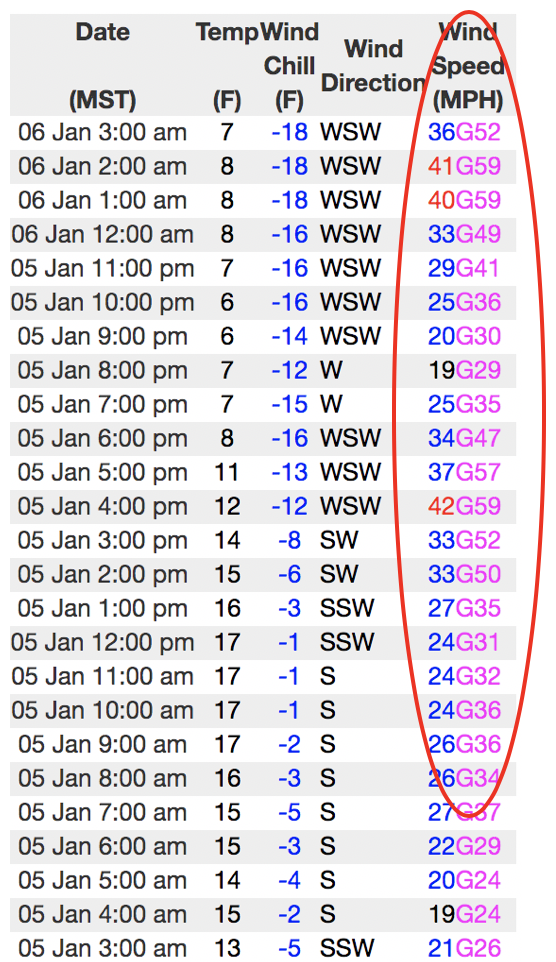
Above is a 24 hour run from Windy Peak, illustrating a bump in this mornings ridgetop winds.
Uinta weather network info is found here. Simply click on the Western Uinta tab.
For today-
Snow winds down quickly this morning as last nights weak storm system departs to the east. Winds should remain strong this morning, shifting to the west-northwest after sunrise, and then taper off through the day as high pressure builds in this afternoon.
Futurecast-
A weakening storm brings the next chance for snow on Wednesday. And then it looks like a stormy period is on track for the last half of the work week.
Recent Avalanches
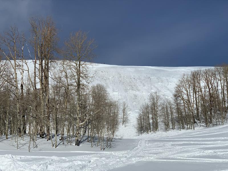
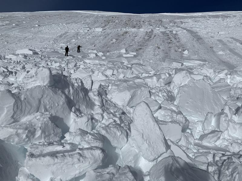
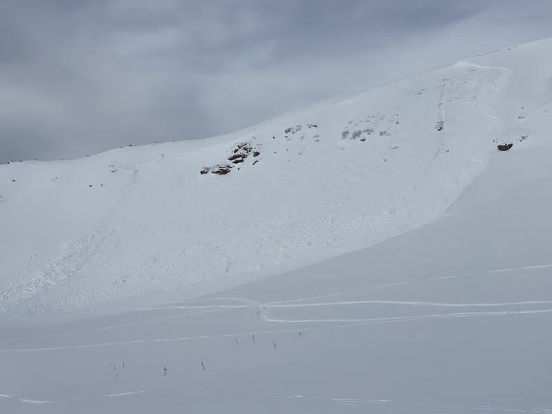
A few days old, but significant none-the-less. On Friday, a group of riders triggered a large avalanche, on a very steep, heavily wind loaded, upper elevation, southeast facing slope near Strawberry Reservoir. Reported as 5' deep and 800' wide and failing on weak snow near the ground, this large slide broke as the rider was climbing the slope. Fortunately he was about 20 feet from the crownline, grabbed some throttle, and was able to punch it to the ridge, narrowly escaping the slide. The big heads up here is... this is a sunny slope, where we generally head to when there's elevated avy danger, expecting to avoid weak snow issues usually found on shady slopes. However, strong northwesterly winds last week, coupled with nearly a foot of midweek storm snow helped connect this very stout slab. And this all rests on lower density snow from the Christmas storm.... strong snow on weak snow. All we need to do is roll along and knock the legs out from underneath. Stoked everyone is OK and deeply appreciate the great reporting from this crew of riders!
To view additional trip reports and recent avalanche activity, simply click here.
Ad
Avalanche Problem #1
Wind Drifted Snow
Type
Location
Likelihood
Size
Description
A great observation from Saturday by long time observer, avy educator, and guide extraordinaire, Cody Hughes viddy shows fresh drifts are reactive to the additional weight of a person. Cody's most excellent observation from yesterday's travels found here.
Winds are cranking and they'll have no problem whipping last nights snow into sensitive drifts, reactive to our additional weight. Most prevalent on upper elevation leeward slopes, I wouldn't be too surprised to find a fresh drift or two cross-loaded onto terrain features like chutes and gullies or even lower down-slope than we usually expect to see. Of course, your best bet for avoidance is to simply steer clear of any fat, rounded piece of snow, especially if it sounds hollow like a drum. In addition, look for shooting cracks in the snow which is a sure sign of unstable conditions.
Avalanche Problem #2
Persistent Weak Layer
Type
Location
Likelihood
Size
Description
A wild card added to the mix of avalanche problems now includes steep, upper elevation slopes, facing the south half of the compass, where strong snow rests on weak snow underneath a post Christmas suncrust. The slide above along the Duchesne Ridge reported Saturday paints a complicated snowpack stability picture.
The good new is... we've got a great start to the season and our pack is looking encouragingly solid, especially where it's deep and nearing 4' of total settled snow. The bad news.... no matter how you cut it, we've got persistent weaknesses on all aspects of the compass, particularly in upper elevation terrain. And the bottom line is... anything persistent in our pack is tricky, can take long periods of time to heal, and snowpit stability tests often suggest false "green light" conditions. So that means, you can ride some slopes and be good to go, while others just wait for us to roll along and knock the legs out from underneath. And here's the danger... once initiated, avalanches have a distinct possibility of breaking deeper and wider than you might expect.
Additional Information
Thanks to the generous support of our Utah ski resorts and Ski Utah, we have discount lift tickets available. All proceeds support the UAC. Get your tickets HERE.
Get one of these cool t-shirts to support the UAC and other avalanche centers across the U.S. INFO
General Announcements
The information in this forecast expires in 24 hours, but will be updated by 7:00 AM Tuesday Jan. 7th.
This forecast is updated daily by 7:00 AM.
In the mean-time, if you see or trigger an avalanche or just wanna let me know what you're seeing you can reach me directly at 801-231-2170
It'll be a minute or two before we're riding, but while you're waiting....
This is a great time of year to schedule one of our free avy awareness presentations.
You can email me directly [email protected]
The information in this forecast is from the US Forest Service which is solely responsible for its content.